AVALANCHE WARNING »
Dangerous avalanche conditions are occuring or are imminent.
Backcountry travel in avalanche terrain is not recommended.
|
 |
Notice: Strong winds and heavy snowfall today and tonight will increase the avalanche danger, first in the mountains north of I-80 as of noon today. The danger will rise to HIGH in the mountains south of I-80, the western Uinta's and central Utah tonight through Thursday. Dangerous backcountry avalanches conditions are developing and will remain elevated through Thursday. |
|
|
SPECIAL ANNOUNCEMENT |
 |
Looking for a safe way to ride Utah's powder during High backcountry avy danger? Click here for discounted lift tickets provided through a great partnership with local ski resorts and Ski Utah. |
|
|
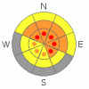
BOTTOM LINE
Danger by aspect and elevation on slopes approaching 35° or steeper.
(click HERE for tomorrow's danger rating)
|
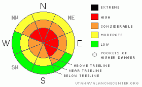
Danger Rose Tutorial
|
In the wind zone at upper elevations a Level 4 (HIGH) avalanche danger exists for both fresh wind drifts and for avalanches which can break into a variety of weak layers. Human triggered avalanches are likely on steep wind drifted slopes, especially those with an easterly component to their aspect.
At mid elevations the avalanche danger will quickly rise from Level 2 (MODERATE) to Level 3 (CONSIDERABLE) once the storm gets going. Human triggered avalanches will be probable on all steep wind drifted slopes.
Low elevation wind sheltered terrain offers a Level 1 (LOW) avalanche danger |
|
|
CURRENT CONDITIONS |

|
Tuesday’s storm was good to the eastern front where over 13” of light density snow fell. Ahead of a cold moist Pacific storm system, south and southwest winds are blowing 25-45 mph along the high ridges. Temperatures are in the low to mid teens. Riding and turning are outstanding, especially in wind sheltered terrain where you’ll find over-the-head and over-the-hood conditions. |
|
|
RECENT ACTIVITY |

|
Yesterday, Trent and I were able to easily trigger shallow, manageable, soft slabs within the new storm snow.
Click here to view recent observations. |
|
|
THREAT #1 |

|
| WHERE |
PROBABILITY |
SIZE |
TREND |

|
|
|
|
| |
|
|
Over the next
24 hours.
|
|
|
Yesterday’s westerly winds created very sensitive soft slabs along the leeward side of upper elevation ridges. Cracking out with little effort, these are manageable slides that break at or below your skis, board, or sled. |
|
|
THREAT #2 |

|
| WHERE |
PROBABILITY |
SIZE |
TREND |
|
|
|
|
| |
|
|
Over the next
24 hours.
|
|
|
There’s more going on in our snowpack than just our predictable surface snow instabilities and just like any cold case, it takes a bit of detective work to reveal. (Click here for a recap of yesterday's field day) A clear cold spell on Feb. 7th formed a layer of surface hoar and near surface facets that are now preserved and buried about two-three feet deep under our last series of storms. This was the culprit weak layer that led to at least a half dozen human triggered slides on Friday and it continues to produce clean shears with quite a bit of energy in our snowpit stability tests. Strong winds and additional new snow load the next few days may help to irritate this weak layer. Human triggered avalanches will be deeper and break wider than you might expect. |
|
|
THREAT #3 |

|
| WHERE |
PROBABILITY |
SIZE |
TREND |

|
|
|
|
| |
|
|
Over the next
24 hours.
|
|
|
While it’s getting more difficult to trigger a deep, dangerous avalanche that breaks to weak snow near the ground, it isn’t out of the question. Steep, rocky, upper elevation, north facing terrain where a thin, weak snowpack is connected to strong snow or terrain that avalanched near the ground in mid January are likely suspects. |
|
|
MOUNTAIN WEATHER |

|
A good looking storm moves into the region today, remaining in place through early Friday. Strong south winds ahead of the cold front today will gust into the 60’s and 70’s, before shifting to the west late today and remain strong into early Thursday. A foot of snow is a good bet by morning. A very cold airmass behind this front keeps snow falling through Thursday night. Snow is expected to taper off Friday. |
|
|
GENERAL ANNOUNCEMENTS |
The information in this advisory expires 24 hours after the date and time posted, but will be updated by 7:00 AM Thursday, March 1st.
If you’re getting out and about and trigger an avalanche or see anything interesting please drop me an email at
craig@utahavalanchecenter.org
or call 801-231-2170 |
|
|
This information does not apply to developed ski areas or highways where avalanche control is normally done. This advisory is from the U.S.D.A. Forest Service, which is solely responsible for its content. This advisory describes general avalanche conditions and local variations always occur. |
|
This advisory provided by the USDA Forest Service, in partnership with:
The Friends of the Utah Avalanche Center, Utah Division of State Parks and Recreation, Utah Division of Emergency Management, Salt Lake County, Salt Lake Unified Fire Authority and the friends of the La Sal Avalanche Center. See our Sponsors Page for a complete list. |
