SPECIAL ANNOUNCEMENT |
|
|
|
BOTTOM LINE
Danger by aspect and elevation on slopes approaching 35° or steeper.
(click HERE for tomorrow's danger rating)
|
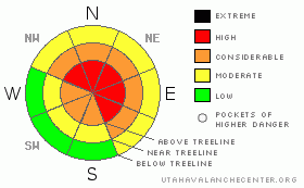
Danger Rose Tutorial
|
In the wind zone at upper elevations a Level 4 (HIGH) avalanche danger exists for both fresh wind drifts and for deep avalanches which can break into weak layers of snow near the ground. Human triggered avalanches are likely on steep wind drifted slopes, especially those with an easterly component to their aspect.
At mid elevations a Level 3 (CONSIDERABLE) avalanche danger will be found and human triggered avalanches are probable on all steep wind drifted slopes.
Even low elevation terrain has seen its fair share of wind and a LEVEL 2 (MODERATE) avalanche danger exists. Human triggered avalanches are possible on steep wind drifted slopes. |
|
|
CURRENT CONDITIONS |

|
Skies are partly cloudy and temperatures are in the single digits, as high pressure makes a brief appearance in between storms. The North Slope did well with yesterday’s storm where 5” of light density snow stacked up. From Trial Lake south most areas only received an inch or two. Westerly winds are more manageable this morning, they’ve backed off into the 30’s and low 40’s along the high ridges. Riding and turning conditions are a mixed bag, but soft settled powder can be found on very wind sheltered shady slopes. |
|
|
RECENT ACTIVITY |

|
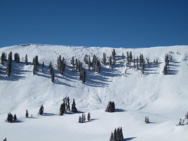
Super Bowl ran huge as a result of Wednesday's hurricane force wind event.
Raging winds resulted in at least two large natural slides that we know of. Ted spotted a big avalanche on Double Hill right before the visibility shut down and the Powder Cats reported a large slide on an unusually low angle slope in Weber Canyon that broke 4’-6’ deep.
In addition, numerous deep avalanches were reported on Friday, both natural and human triggered. A brief glimpse includes most of Super Bowl, the east side of Moffit Peak, and a couple of partial burials on Double Hill. Avalanches are breaking to old snow and are hardly manageable.
Click here to view recent observations. |
|
|
THREAT #1 |

|
| WHERE |
PROBABILITY |
SIZE |
TREND |

|
|
|
|
| |
|
|
Over the next
24 hours.
|
|
|

On Friday, Ted rolled up on the recently triggered avalanche as the group was digging out and brushing themselves off. Fortunately this group dodged a bullet and all were OK.
Yesterday’s west and southwest winds raged into the 70’s and 80’s, depositing snow in unusual locations, changing the landscape of the eastern front. Today’s stout hard slabs will pack a punch, breaking deeper and wider then you might expect, failing on a variety of weak layers. Conditions will change from slope to slope. If you’re riding multiple drainages today, carefully reevaluate your terrain choices throughout the day and think about the consequences of triggering a slide. |
|
|
THREAT #2 |

|
| WHERE |
PROBABILITY |
SIZE |
TREND |

|
|
|
|
| |
|
|
Over the next
24 hours.
|
|
|
Unmanageably deep, dangerous avalanches breaking to the ground are a distinct possibility today, especially in areas where thin weak snow is connected to a strong feeling slab. The most likely place to trigger a big scary slide is going to be steep, upper elevation, wind-loaded, rocky terrain. Triggering a slide on a slope with these characteristics will have a devastating outcome. |
|
|
THREAT #3 |

|
| WHERE |
PROBABILITY |
SIZE |
TREND |

|
|
|
|
| |
|
|
Over the next
24 hours.
|
|
|
Cornices have grown and can break back further than you might expect. |
|
|
MOUNTAIN WEATHER |

|
Weak high pressure builds as yesterday’s storm heads east. We should see mostly sunny skies developing with highs reaching into the mid 20’s. Winds decrease throughout the day, switch to the northwest, before ramping back up tonight. Winds increase significantly tonight as the next storm system carves its way through our region late Monday. The storm will linger through Tuesday with storm totals in the 6”-12” range. |
|
|
GENERAL ANNOUNCEMENTS |
The information in this advisory expires 24 hours after the date and time posted, but will be updated by 7:00 AM Wednesday, February 29th.
If you’re getting out and about and trigger an avalanche or see anything interesting please drop me an email at
craig@utahavalanchecenter.org
or call 801-231-2170 |
|
|
This information does not apply to developed ski areas or highways where avalanche control is normally done. This advisory is from the U.S.D.A. Forest Service, which is solely responsible for its content. This advisory describes general avalanche conditions and local variations always occur. |
|
This advisory provided by the USDA Forest Service, in partnership with:
The Friends of the Utah Avalanche Center, Utah Division of State Parks and Recreation, Utah Division of Emergency Management, Salt Lake County, Salt Lake Unified Fire Authority and the friends of the La Sal Avalanche Center. See our Sponsors Page for a complete list. |
