SPECIAL ANNOUNCEMENT |
 |
A Special Avalanche Advisory is in effect for the mountains of northern and Central Utah, including the western Uinta’s. Strong winds and recent snowfall is creating dangerous avalanche conditions. Human triggered avalanches are likely. |
|
|
BOTTOM LINE
Danger by aspect and elevation on slopes approaching 35° or steeper.
(click HERE for tomorrow's danger rating)
|
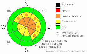
Danger Rose Tutorial
|
In the wind zone at upper elevations a Level 3 (CONSIDERABLE) avalanche danger exists for both fresh wind drifts and for deeper slides in terrain where a strong slab overlays a thin, weak snowpack. Human triggered avalanches are likely on steep wind drifted slopes, especially those with an easterly component to their aspect.
At mid elevations a Level 2 (MODERATE) avalanche danger will be found and human triggered avalanches are possible on all steep wind drifted slopes.
A Level 1 (LOW) avalanche danger will be found in lower elevation, wind sheltered terrain. |
|
|
CURRENT CONDITIONS |

|
Two inches of dense, heavy snow fell yesterday and currently skies are cloudy with temperatures in the low 30’s. West-southwest winds are cranking 30-50 mph. along the ridges. Riding and turning conditions are a mixed bag up high, but you’ll find soft, settled powder on wind sheltered shady slopes at mid elevations. |
|
|
RECENT ACTIVITY |

|
Numerous shallow soft slabs at upper elevations reported throughout the range yesterday.
Click here to view recent observations. |
|
|
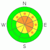
THREAT #1 |

|
| WHERE |
PROBABILITY |
SIZE |
TREND |
|
|
|
|
| |
|
|
Over the next
24 hours.
|
|
|
Winds have always been the great equalizer on the eastern front and the past few days the range has lived up to its reputation. Yesterday, shallow soft slabs rapidly formed on the leeward side of ridges, around terrain features like chutes and gullies, and lower downslope than you might expect. With continued wind overnight and more expected today, drifting is more widespread and today’s slabs will break deeper than you’d anticipate. |
|
|
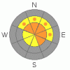
THREAT #2 |

|
| WHERE |
PROBABILITY |
SIZE |
TREND |
|
|
|
|
| |
|
|
Over the next
24 hours.
|
|
|
Not much has changed with our problem child, the weak snow near the ground, especially where the snowpack remains thin and a strong slab overlays weak sugary snow. Unless you dig down to investigate the strong snow over weak snow setup, conditions will feel bomber and good to go under our sled. This is exactly the kind of combination that lures us well out onto the slope before it fails and we’re off to the races. In steep, rocky, upper elevation terrain facing the north half of the compass, you can still trigger a deep, dangerous slide that breaks to the dirt. Today you’ll need to continue re-evaluating your terrain choices and think about the consequences of triggering a slide. |
|
|
MOUNTAIN WEATHER |

|
A moist northwesterly flow over the region ushers in scattered snow showers with continued strong winds in the 50’s with gusts in the 70’s late in the day. Temperatures remain mild with highs in the mid 30’s. A cold front moves into the area late today and snow should develop with 3”-6” expected by Thursday morning. High pressure will strengthen later Thursday into Friday, before another storm system impacts the region Saturday and Sunday. |
|
|
GENERAL ANNOUNCEMENTS |
The information in this advisory expires 24 hours after the date and time posted, but will be updated by 7:00 AM Saturday, February 25th.
If you’re getting out and about and trigger an avalanche or see anything interesting please drop me an email at
craig@utahavalanchecenter.org
or call 801-231-2170 |
|
|
This information does not apply to developed ski areas or highways where avalanche control is normally done. This advisory is from the U.S.D.A. Forest Service, which is solely responsible for its content. This advisory describes general avalanche conditions and local variations always occur. |
|
This advisory provided by the USDA Forest Service, in partnership with:
The Friends of the Utah Avalanche Center, Utah Division of State Parks and Recreation, Utah Division of Emergency Management, Salt Lake County, Salt Lake Unified Fire Authority and the friends of the La Sal Avalanche Center. See our Sponsors Page for a complete list. |
