SPECIAL ANNOUNCEMENT |
 |
A Special Avalanche Advisory has been issued for the western Uinta mountains. Heavy snowfall today into tonight will increase the avalanche danger through the Holiday weekend. |
|
|
BOTTOM LINE
Danger by aspect and elevation on slopes approaching 35° or steeper.
(click HERE for tomorrow's danger rating)
|
Danger Rose Tutorial
|
A Level 3 (CONSIDERABLE) avalanche danger exists in steep terrain at upper elevations in the wind zone, especially on slopes where a strong slab overlays a thin, weak snowpack. As the storm develops human triggered avalanches may become more likely, especially as the day wares on.
At mid elevations a Level 2 (MODERATE) avalanche danger will be found and human triggered avalanches are possible on all steep wind drifted slopes.
A Level 1 (LOW) avalanche danger will be found on low angle slopes and at lower elevations which receive less snow and wind. |
|
|
CURRENT CONDITIONS |

|
Snowfall started early this morning and so far most stations are reporting just an inch or two. Temperatures are in the low to mid 20’s and southwest winds are blowing 10-15 mph. It won’t be hard to find quality snow today. |
|
|
RECENT ACTIVITY |

|
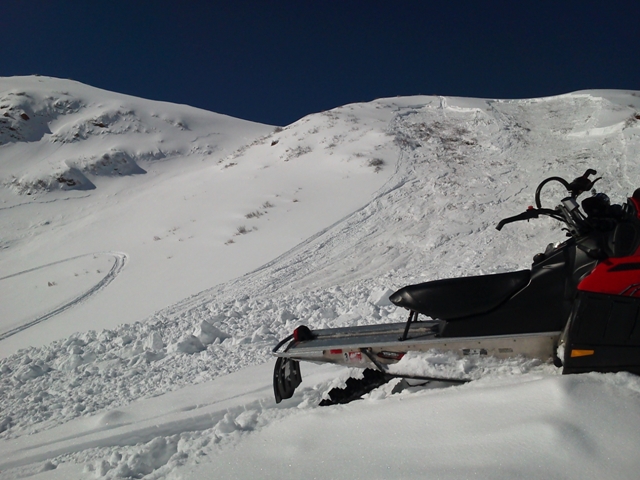
Three sledders riding on private property without permission triggered a hard slab avalanche on an upper elevation west facing slope near Windy Peak yesterday morning. The riders were all on the slope at the same time and came out unscathed. Unfortunately, they didn’t stop to tell others around them and an unnecessary search took place.
Thanks to the quick response of Park City Powdercats who needlessly had to shut down their operation and perform an unnecessary search of the avalanche debris. 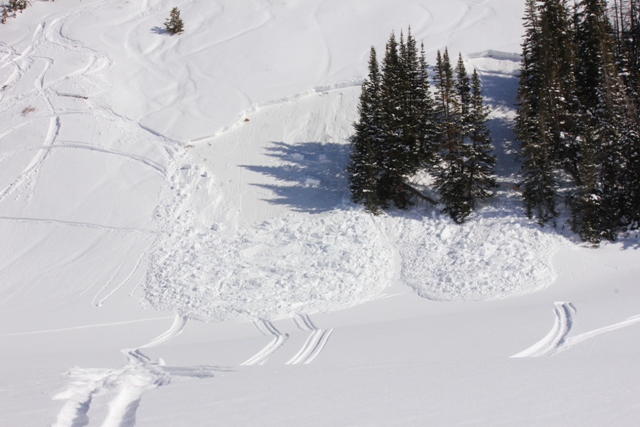 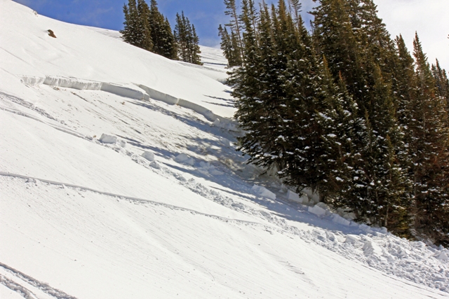
No matter what the circumstances… if you trigger a slide let others in the area know you’re good to go so they don’t risk their lives and resources chasing a mystery!
Also, huge thanks to Kendall, Matt, and Ian for the great observations this week. Click here to view. |
|
|
THREAT #1 |

|
| WHERE |
PROBABILITY |
SIZE |
TREND |

|
|
|
|
| |
|
|
Over the next
24 hours.
|
|
|
In late breaking news... this 3'-5' deep slide was triggered was triggered Thursday in Racetrack Bowl. The avalanche broke about 30' above the rider and failed on weak sugary snow near the ground. All came out uninjured and on top, but this was a close call for sure.
Nothing has changed on this front and yesterday’s sled triggered avy demonstrates you just need to stumble onto the right combination of strong over weak snow. Trent and I have been stomping around in Chalk Creek finding the continued theme of strong snow resting on weak sugary snow which formed during the historic December dry spell. It’s amazing we’re still talking about weak snow near the ground and here it is the middle of February. But, this is the Uinta’s after all and this type of snowpack is what we’re used to dealing with…. just not usually this late in the season.
Our snowpit stability tests continue to produce failures on weak snow near the ground. All you need to do is find the right combination of a strong slab resting over a thin weak section of the snowpack in order to rile the weak layer and trigger a dangerous avalanche. While chances of this occurring are isolated, the results would be devastating. The most likely terrain you’d encounter this condition is steep, upper elevation, rocky terrain, especially on slopes facing the north half of the compass. |
|
|
THREAT #2 |

|
| WHERE |
PROBABILITY |
SIZE |
TREND |

|
|
|
|
| |
|
|
Over the next
24 hours.
|
|
|
Once the storm gets going and the new snow starts to stack up it will become more sensitive to the weight of a rider. Today’s surface snow instabilities will be easy to manage, but could knock you into a tree and ruin your day in a hurry. Should winds pick up, carefully reevaluate your terrain choices, especially if your travels are taking you into steep, leeward, upper elevation terrain. |
|
|
MOUNTAIN WEATHER |

|
Today we should see periods of heavy snow with 6”-12” by early evening a good bet. West and northwest winds gust into the 20’s and 30’s along the high ridges and temperatures begin to dive into the low teens. High pressure briefly returns Monday, before a moist northwest flow brings additional snow Tuesday through Thursday. |
|
|
GENERAL ANNOUNCEMENTS |
The information in this advisory expires 24 hours after the date and time posted, but will be updated by 7:00 AM Monday, February 20th.
If you’re getting out and about and trigger an avalanche or see anything interesting please drop me an email at
craig@utahavalanchecenter.org
or call 801-231-2170 |
|
|
This information does not apply to developed ski areas or highways where avalanche control is normally done. This advisory is from the U.S.D.A. Forest Service, which is solely responsible for its content. This advisory describes general avalanche conditions and local variations always occur. |
|
This advisory provided by the USDA Forest Service, in partnership with:
The Friends of the Utah Avalanche Center, Utah Division of State Parks and Recreation, Utah Division of Emergency Management, Salt Lake County, Salt Lake Unified Fire Authority and the friends of the La Sal Avalanche Center. See our Sponsors Page for a complete list. |
