SPECIAL ANNOUNCEMENT |
 |
It is with a heavy heart that I report a good friend of ours, Brady Davis, was killed in an avalanche near Fish Lake on Sunday. Our thoughts and prayers go out to Brady’s family and friends. A report of the accident can be found here. |
|
|
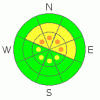
BOTTOM LINE
Danger by aspect and elevation on slopes approaching 35° or steeper.
(click HERE for tomorrow's danger rating)
|

Danger Rose Tutorial
|
At and above treeline pockets of Level 3 (CONSIDERABLE) avalanche danger exist for deep slides that break to the ground. Human triggered avalanches are likely, especially on steep, upper elevation, wind drifted slopes facing the north half of the compass.
At mid elevations a Level 2 (MODERATE) avalanche danger will be found and human triggered avalanches are possible on steep, northerly facing, wind drifted slopes.
Slopes facing the south half of the compass at mid and low elevations and terrain that had no snow prior to the big storm offer Level 1 (LOW) avalanche danger. |
|
|
CURRENT CONDITIONS |

|
A weak storm system just to the west of the state ushered in a blanket of clouds overnight keeping temperatures in the low to mid 20’s. Southerly winds have been blowing steadily at 20-30 mph along the ridges since about 8:00 last night. Excellent riding and turning conditions can be found on mid elevation wind sheltered terrain. |
|
|
RECENT ACTIVITY |

|
A few shallow hard slabs were crow-barred out yesterday along the high ridges and booming collapses continue to put your heart into arrhythmia.
Click here for recent observations. |
|
|
THREAT #1 |

|
| WHERE |
PROBABILITY |
SIZE |
TREND |
|
|
|
|
| |
|
|
Over the next
24 hours.
|
|
|
Ted and I stomped around Chalk Creek yesterday and we were amazed at the overall weak structure of the snowpack, especially near the ground. Of course it’s not the top to bottom facet factory, sugary wallow fest it was before the big storm a few weeks ago. Nope… it’s scarier now because there’s a solid feeling slab on top of this junk show near the ground. So why is it so tricky? You can ride plenty of slopes and be good to go, but when you find the right combination of strong snow over weak snow, it’s easy to kick the legs out from under the slab and you’re off to the races. This condition is most prevalent on upper elevation, northerly facing terrain, especially on the leeward side of the high ridgelines.
We’re dealing with an unusual snowpack this year and it’s creating unusual avalanche conditions. But, it doesn’t mean you can’t go out and have fun. There’s plenty of low angle terrain to shred throughout the range, where you won’t even have to worry about avalanches.
Carefully study the terrain you’re riding today. If it’s upper elevation wind drifted terrain, steeper than 35 degrees, facing the north half of the compass, and didn’t avalanche during the big storm it’s no-go terrain.
The avalanche danger is less pronounced on south facing slopes, low angle meadows and terrain that didn’t have snow prior to the big storm. |
|
|
MOUNTAIN WEATHER |

|
A weak but moist storm system crosses the region today and tonight, bringing with it some light snow showers with overnight accumulations in the 2”-4” range. Temperatures reach into the upper 20’s before diving into the teens overnight. Winds switch to the west and then northwest later today and gust into the 30’s along the high ridges. High pressure builds back into the area Thursday through Friday bringing a warming trend. Another splitting storm brings a chance of snow over the weekend continuing through the first part of next week. |
|
|
GENERAL ANNOUNCEMENTS |
The information in this advisory expires 24 hours after the date and time posted, but will be updated by 7:00 AM Saturday, February 11th.
If you’re getting out and about and trigger an avalanche or see anything interesting please drop me an email at
craig@utahavalanchecenter.org
or call 801-231-2170 |
|
|
This information does not apply to developed ski areas or highways where avalanche control is normally done. This advisory is from the U.S.D.A. Forest Service, which is solely responsible for its content. This advisory describes general avalanche conditions and local variations always occur. |
|
This advisory provided by the USDA Forest Service, in partnership with:
The Friends of the Utah Avalanche Center, Utah Division of State Parks and Recreation, Utah Division of Emergency Management, Salt Lake County, Salt Lake Unified Fire Authority and the friends of the La Sal Avalanche Center. See our Sponsors Page for a complete list. |
