SPECIAL ANNOUNCEMENT |
|
|
|
BOTTOM LINE
Danger by aspect and elevation on slopes approaching 35° or steeper.
(click HERE for tomorrow's danger rating)
|
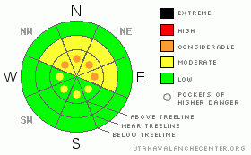
Danger Rose Tutorial
|
At and above treeline pockets of Level 3 (CONSIDERABLE) avalanche danger exist for deep slides that break to the ground. Human triggered avalanches are likely, especially on steep, upper elevation, wind drifted slopes facing the north half of the compass.
At mid elevations a Level 2 (MODERATE) avalanche danger will be found and human triggered avalanches are possible on steep, northerly facing, wind drifted slopes.
Slopes facing the south half of the compass at mid and low elevations and terrain that had no snow prior to the big storm offer Level 1 (LOW) avalanche danger. |
|
|
CURRENT CONDITIONS |

|
It’s clear and cool on the eastern front. Temperatures are generally in the upper single digits and low teens with a few outliers where cold air pools. Lily Lake is -2 degrees and Mirror Lake clocks in at -10 degrees. Southeast winds are light, blowing 10-20 mph along the ridges. Even though much of our terrain is pitifully shallow and rocky, riding and turning conditions remain quite good. |
|
|
RECENT ACTIVITY |

|
One sled triggered slide, 3 feet deep and 100 feet wide, was reported south of Currant Creek Peak on a heavily wind loaded east facing slope. Click here to view.
In addition, loud, booming, localized collapses continue throughout the range.
Click here for recent observations. |
|
|
THREAT #1 |

|
| WHERE |
PROBABILITY |
SIZE |
TREND |
|
|
|
|
| |
|
|
Over the next
24 hours.
|
|
|
After a number of booming collapses yesterday, Ted’s partner looked at him and said, “Is it always like this out here?” Actually, thin snowpack’s with a persistent buried weakness like ours this year can collapse until the snow is flowing out of our taps in the summer… yup, it’ll haunt us that long. What does it mean for avalanches and snow stability? Well, the big storm snow from two weeks ago has settled out and is strong and cohesive, that’s the snow that feels solid and bomber under our sled. Remember though, it rests on very weak sugary snow near the ground. No surprise there, that’s what we deal with in the western Uinta’s. The way to deal with it safely is by choosing lower angle terrain or slopes that avalanched to the ground during the big storm. The most likely type of terrain you could trigger a big, deep, scary slide today is in steep, rocky terrain, particularly on upper elevation wind drifted slopes facing the north half of the compass. (This video pretty much sums it all up.)
Carefully study the terrain you’re riding today. If it’s upper elevation wind drifted terrain, steeper than 35 degrees, facing the north half of the compass, and didn’t avalanche during the big storm it’s no-go terrain.
The avalanche danger is less pronounced on south facing slopes, low angle meadows and terrain that didn’t have snow prior to the big storm. |
|
|
MOUNTAIN WEATHER |

|
Mostly sunny skies and cool temperatures are on tap today. Winds shift to the north later this afternoon, but remain relatively well behaved in the 10-20 mph range. After highs climb into the upper 20’s, overnight lows dip into the single digits. High pressure builds for the early part of the week before a weak storm brushes by the region Wednesday and Wednesday night. Clear skies rebound for the latter half of the week. |
|
|
GENERAL ANNOUNCEMENTS |
The information in this advisory expires 24 hours after the date and time posted, but will be updated by 7:00 AM Wednesday, February 8th.
If you’re getting out and about and trigger an avalanche or see anything interesting please drop me an email at
craig@utahavalanchecenter.org
or call 801-231-2170 |
|
|
This information does not apply to developed ski areas or highways where avalanche control is normally done. This advisory is from the U.S.D.A. Forest Service, which is solely responsible for its content. This advisory describes general avalanche conditions and local variations always occur. |
|
This advisory provided by the USDA Forest Service, in partnership with:
The Friends of the Utah Avalanche Center, Utah Division of State Parks and Recreation, Utah Division of Emergency Management, Salt Lake County, Salt Lake Unified Fire Authority and the friends of the La Sal Avalanche Center. See our Sponsors Page for a complete list. |
