SPECIAL ANNOUNCEMENT |
 |
The east side of the range got clobbered from the Wednesday/Thursday storm with close to two feet of snow and the avalanche danger will be slightly higher in this region. |
|
|
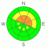
BOTTOM LINE
Danger by aspect and elevation on slopes approaching 35° or steeper.
(click HERE for tomorrow's danger rating)
|

Danger Rose Tutorial
|
At and above treeline a Level 3 (CONSIDERABLE) avalanche danger exists for deep slides that break to the ground. Human triggered avalanches are likely, especially on steep, upper elevation, wind drifted slopes facing the north half of the compass.
At mid elevations a Level 2 (MODERATE) avalanche danger will be found and human triggered avalanches are possible on steep, northerly facing, wind drifted slopes.
Slopes facing the south half of the compass at mid and low elevations and terrain that had no snow prior to the big storm offer Level 1 (LOW) avalanche danger. |
|
|
CURRENT CONDITIONS |

|
High pressure once again dominates our weather pattern. Skies are clear, temperatures in the low to mid teens, and winds are about as light as they get blowing 5-10 mph even along the high ridges. Thursday night’s storm laid down 6” of light density snow providing excellent riding and turning conditions. |
|
|
RECENT ACTIVITY |

|
No significant new avalanche activity since last Saturday, but the snowpack continues to produce localized collapsing and whoomphing sounds. Click here for recent observations. |
|
|
THREAT #1 |

|
| WHERE |
PROBABILITY |
SIZE |
TREND |
|
|
|
|
| |
|
|
Over the next
24 hours.
|
|
|
The snowpack continues to adjust to the big storm two weeks ago and avalanches are getting harder to trigger…. that’s the good news. The bad news is…. the slides we can trigger today will be deep, dangerous, and unmanageable. (This video pretty much sums it all up.) Yes, our problem child, the early season snow near the ground, continues to haunt us and anyone who has spent time around snowpacks like ours doesn’t trust them with their lives. How do ride under conditions like these when the probability decreases, but the consequences increase? Just like the guy in the loud plaid jacket talks about location, location, location. In this business it’s terrain, terrain, terrain. That’s the ticket.
Carefully study the terrain you’re riding today. If it’s upper elevation wind drifted terrain, steeper than 35 degrees, facing the north half of the compass, and didn’t avalanche during the big storm it’s no-go terrain.
The avalanche danger is less pronounced on south facing slopes, low angle meadows and terrain that didn’t have snow prior to the big storm. |
|
|
MOUNTAIN WEATHER |

|
Mostly sunny skies are expected today with highs reaching into the mid to upper 20’s and overnight lows dive into the single digits. Winds may increase throughout the day and gust in the 20’s and 30’s along the highest ridges. We might see a flurry or two at times, but in general high pressure builds throughout the early portion of next week. |
|
|
GENERAL ANNOUNCEMENTS |
The information in this advisory expires 24 hours after the date and time posted, but will be updated by 7:00 AM Sunday, February 5th.
If you’re getting out and about and trigger an avalanche or see anything interesting please drop me an email at
craig@utahavalanchecenter.org
or call 801-231-2170 |
|
|
This information does not apply to developed ski areas or highways where avalanche control is normally done. This advisory is from the U.S.D.A. Forest Service, which is solely responsible for its content. This advisory describes general avalanche conditions and local variations always occur. |
|
This advisory provided by the USDA Forest Service, in partnership with:
The Friends of the Utah Avalanche Center, Utah Division of State Parks and Recreation, Utah Division of Emergency Management, Salt Lake County, Salt Lake Unified Fire Authority and the friends of the La Sal Avalanche Center. See our Sponsors Page for a complete list. |
