SPECIAL ANNOUNCEMENT |
 |
Big thanks to Trent and Clint for helping to install the BCA Beacon Checker at the Mirror Lake Highway trailhead yesterday. |
|
|
BOTTOM LINE
Danger by aspect and elevation on slopes approaching 35° or steeper.
(click HERE for tomorrow's danger rating)
|
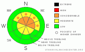
Danger Rose Tutorial
|
At and above treeline a Level 3 (CONSIDERABLE) avalanche danger exists for deep slides that break to the ground. Human triggered avalanches are likely, especially on steep, upper elevation, wind drifted slopes facing the north half of the compass.
At mid elevations a Level 2 (MODERATE) avalanche danger will be found and human triggered avalanches are possible on steep, northerly facing, wind drifted slopes.
Slopes facing the south half of the compass at mid and low elevations and terrain that had no snow prior to the big storm offer Level 1 (LOW) avalanche danger. |
|
|
CURRENT CONDITIONS |

|
High clouds drifted into the area overnight and will camp out the next couple days as a weak storm system brushes by northern Utah. West and southwest winds are blowing 20-25 mph along the high ridges and temperatures are in the mid teens. Riding and turning conditions remain quite good. |
|
|
RECENT ACTIVITY |

|
No new avalanche activity since Saturday, but the snowpack continues to produce localized collapsing and whoomphing sounds. Click here for recent observations. |
|
|
THREAT #1 |

|
| WHERE |
PROBABILITY |
SIZE |
TREND |

|
|
|
|
| |
|
|
Over the next
24 hours.
|
|
|
The snowpack is gaining strength and yes, it’s getting harder to trigger avalanches. As the pack settles the snow will feel strong, solid, and good to go, but this false sense of snow stability only lures us deeper into the avalanche dragons den. Remember- just a few days ago people were triggering avalanches breaking to the ground. Our problem child, the sugary snow near the ground, isn’t going away anytime soon and the overall snowpack structure remains suspect, especially in steep rocky terrain. More importantly, the consequences of triggering an avalanche are severe. Check out this great video from Bald Mountain Pass yesterday clearly describing what we’re up against.
There’s plenty of great low angle riding out there where you can have a blast and not even worry about avalanches. |
|
|
MOUNTAIN WEATHER |

|
Cloudy skies and light snow showers develop later today as an approaching trough currently over northern California slides though the region. Southwesterly winds gust into the 30’s along the high ridges and temperatures climb into the mid 30’s before diving into the teens overnight. A couple inches of snow are expected by Thursday morning, but this isn’t a big storm. Scattered snow showers are on tap for Thursday and early Friday and then it looks like high pressure returns for the weekend and remains though next week. |
|
|
GENERAL ANNOUNCEMENTS |
The information in this advisory expires 24 hours after the date and time posted, but will be updated by 7:00 AM Saturday, February 4th.
If you’re getting out and about and trigger an avalanche or see anything interesting please drop me an email at
craig@utahavalanchecenter.org
or call 801-231-2170 |
|
|
This information does not apply to developed ski areas or highways where avalanche control is normally done. This advisory is from the U.S.D.A. Forest Service, which is solely responsible for its content. This advisory describes general avalanche conditions and local variations always occur. |
|
This advisory provided by the USDA Forest Service, in partnership with:
The Friends of the Utah Avalanche Center, Utah Division of State Parks and Recreation, Utah Division of Emergency Management, Salt Lake County, Salt Lake Unified Fire Authority and the friends of the La Sal Avalanche Center. See our Sponsors Page for a complete list. |
