SPECIAL ANNOUNCEMENT |
 |
Sad news from the Central Wasatch yesterday, where a backcountry snowboarder was tragically killed in a large avalanche off the west side of Kessler Peak. Our deepest sympathy along with heartfelt prayers go out to friends and family of 24-year-old Alecsander Barton. A preliminary report is posted on our website. |
|
|
BOTTOM LINE
Danger by aspect and elevation on slopes approaching 35° or steeper.
(click HERE for tomorrow's danger rating)
|
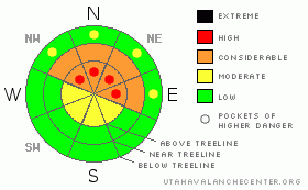
Danger Rose Tutorial
|
At and above treeline pockets of Level 4 (HIGH) avalanche danger exist for deep slides that break to the ground. Human triggered avalanches are very likely, especially on steep, upper elevation, wind drifted slopes facing the north half of the compass.
At mid elevations a Level 3 (CONSIDERABLE) avalanche danger will be found and human triggered avalanches are probable on steep, northerly facing, wind drifted slopes.
Slopes facing the south half of the compass at mid and low elevations and terrain that had no snow prior to the big storm offer Level 1 (LOW) avalanche danger. |
|
|
CURRENT CONDITIONS |

|
High pressure centered across the region today is giving us clear skies this morning. West and northwest winds are blowing 20-30 mph along the high ridges and temperatures are in the low to mid teens. Excellent low angle riding and turning conditions are the ticket today. |
|
|
RECENT ACTIVITY |

|
Three large avalanches were remotely triggered from several hundred feet away in Chalk Creek yesterday. Breaking 3’-4’ deep and about 100’ wide, the slides occurred in steep, upper elevation north facing terrain that didn’t avalanche naturally during last weekend’s big storm. In addition, booming collapses continue to resonate throughout the range.

Friday, Ted took a look at a large slide that was triggered on the northeast side of Elizabeth Pass on Tuesday. Deep, wide, and breaking to the ground, this was a close call for a couple of very experienced locals. In addition, heart stopping whoomphs that sound like rolling thunder continue throughout the range. Click here to see his report.
Click here for recent observations. |
|
|
THREAT #1 |

|
| WHERE |
PROBABILITY |
SIZE |
TREND |
|
|
|
|
| |
|
|
Over the next
24 hours.
|
|
|
Not much has changed since yesterday and that’s the problem with a persistent buried weakness like what we’re dealing with this season. Yes, this year is different and we’re not talkin’ new snow instabilities where you wait a few days, the storm snow settles, and you can ride it safely if it’s white. Our setup right now is super tricky because the weakness near the ground takes a long time to heal, reacting to our additional weight for weeks after a storm. The stiff, strong feeling slabs allow us to get well out onto the slope giving us a false sense of snow stability. But we need to remember that all this strong snow rests on a structurally challenged base of rotten, sugary snow. Any steep slope, especially those that didn’t avalanche during last weekend’s big storm, remain dangerously suspect and need to be avoided. |
|
|
MOUNTAIN WEATHER |

|
High pressure provides a beautiful day in the mountains with temperatures climbing into the mid 30’s before diving into the upper teens overnight. Northwest winds remain fairly well behaved, gusting into the 30’s along the most exposed ridgelines. Increasing clouds on Monday signal the first in a series of weak storms which brush by the region through midweek, leaving little snow accumulation in its wake. High pressure and dry weather return for the latter half of the week. |
|
|
GENERAL ANNOUNCEMENTS |
The information in this advisory expires 24 hours after the date and time posted, but will be updated by 7:00 AM Wednesday, February 1st.
If you’re getting out and about and trigger an avalanche or see anything interesting please drop me an email at
craig@utahavalanchecenter.org
or call 801-231-2170 |
|
|
This information does not apply to developed ski areas or highways where avalanche control is normally done. This advisory is from the U.S.D.A. Forest Service, which is solely responsible for its content. This advisory describes general avalanche conditions and local variations always occur. |
|
This advisory provided by the USDA Forest Service, in partnership with:
The Friends of the Utah Avalanche Center, Utah Division of State Parks and Recreation, Utah Division of Emergency Management, Salt Lake County, Salt Lake Unified Fire Authority and the friends of the La Sal Avalanche Center. See our Sponsors Page for a complete list. |
