SPECIAL ANNOUNCEMENT |
 |
I will be giving a free avalanche awareness presentation tonight at 6:30 geared specifically for sledders at
MORGAN VALLEY POLARIS, 800 E 100 S, MORGAN, UT. Click here for more details. |
|
|
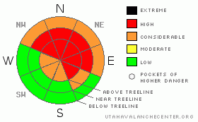
BOTTOM LINE
Danger by aspect and elevation on slopes approaching 35° or steeper.
(click HERE for tomorrow's danger rating)
|
Danger Rose Tutorial
|
At and above treeline a Level 4 (HIGH) avalanche danger exists for both fresh wind drifts and deep slides that break to the ground. Human triggered avalanches are very likely, especially on steep, upper elevation, wind drifted slopes facing the north half of the compass.
At mid elevations a Level 3 (CONSIDERABLE) avalanche danger will be found on steep, northerly facing slopes. Human triggered avalanches are probable on steep wind drifted slopes.
Slopes facing the south half of the compass at mid and low elevations that had no snow prior to the big storm offer Level 1 (LOW) avalanche danger. |
|
|
CURRENT CONDITIONS |

|
Clouds are streaming into the region, temperatures are in the upper teens and low 20’s, and westerly winds are blowing 15-25 mph along the ridges. The storm snow is settling and riding conditions remain quite good on low angle slopes. |
|
|
RECENT ACTIVITY |

|
No new avalanches to report, but collapsing and heart stopping whoomphs continue to be the theme on the eastern front.
Click here for recent observations. |
|
|
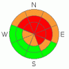
THREAT #1 |

|
| WHERE |
PROBABILITY |
SIZE |
TREND |
|
|
|
|
| |
|
|
Over the next
24 hours.
|
|
|
Yesterday was the first day in nearly a week when we didn’t hear about any deep, dangerous, human triggered avalanches breaking to the ground. While that’s a sign the snowpack is slowly healing and adjusting to last week’s big storm, the fact of the matter is our snowpack remains suspect. A huge red flag is the daily reports of widespread collapsing, especially on low angle slopes. This screams “unstable snow” and tells me you just need to find the right combination of strong snow over weak snow. If you collapse a steep, upper elevation, wind drifted slope, chances are you’ll be staring down the barrel of a very dangerous avalanche.
These aren’t the kind of slides where we dust ourselves off, high five our buddies, and convince each other avalanches are part of the sport. These are tree snapping, bone crushing avalanches, which can be avoided by staying off of steep slopes. The season is just getting going and with all the great low angle riding out there it’s just not worth the risk if we screw up. |
|
|
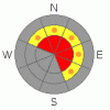
THREAT #2 |

|
| WHERE |
PROBABILITY |
SIZE |
TREND |
|
|
|
|
| |
|
|
Over the next
24 hours.
|
|
|
Winds gusted into the 30’s and 40’s yesterday, forming wind drifts along the leeward side of upper elevation ridges, especially on slopes with an easterly component to their aspect.. This morning’s slabs are easy to detect and manageable in size. However, as the day wares on and winds increase, drifting will become more widespread and slabs may break a bit deeper and wider than you might expect. |
|
|
MOUNTAIN WEATHER |

|
A westerly flow over the region will help to usher in a cold front slated to impact northern Utah late this afternoon. West and southwest winds blow in the 20’s and 30’s with gusts in the 60’s along the high ridges. Temperatures climb into the 30’s before diving into the teens overnight. Snow should develop late today with 6”-10” expected by Friday morning. High pressure builds for the weekend. |
|
|
GENERAL ANNOUNCEMENTS |
The information in this advisory expires 24 hours after the date and time posted, but will be updated by 7:00 AM Saturday, January 28th.
If you’re getting out and about and trigger an avalanche or see anything interesting please drop me an email at
craig@utahavalanchecenter.org
or call 801-231-2170 |
|
|
This information does not apply to developed ski areas or highways where avalanche control is normally done. This advisory is from the U.S.D.A. Forest Service, which is solely responsible for its content. This advisory describes general avalanche conditions and local variations always occur. |
|
This advisory provided by the USDA Forest Service, in partnership with:
The Friends of the Utah Avalanche Center, Utah Division of State Parks and Recreation, Utah Division of Emergency Management, Salt Lake County, Salt Lake Unified Fire Authority and the friends of the La Sal Avalanche Center. See our Sponsors Page for a complete list. |
