AVALANCHE WARNING »
Dangerous avalanche conditions are occuring or are imminent.
Backcountry travel in avalanche terrain is not recommended.
|
 |
Notice: The avalanche warning continues for all the mountains of northern Utah. Deadly human triggered avalanches continue to be very likely on steeper slopes. Avalanches can be triggered from a distance so stay out from underneath steep slopes as well. People without expert level backcountry avalanche skills are urged to stay out of the backcountry. |
|
|
SPECIAL ANNOUNCEMENT |
 |
Huge thanks to Tim and the U Crew for helping to get Trent and I out of a tight spot Sunday. |
|
|
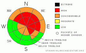
BOTTOM LINE
Danger by aspect and elevation on slopes approaching 35° or steeper.
(click HERE for tomorrow's danger rating)
|
Danger Rose Tutorial
|
A Level 4 (HIGH) avalanche danger exists. Deep, dangerous, unsurvivable human triggered avalanches are very likely, especially on steep wind drifted slopes facing the north half of the compass. At and above treeline in the wind zone, historically large, human triggered, tree snapping avalanches are certain on steep, wind loaded slopes.
Lower elevation terrain is getting in on the act as well and a Level 3 (CONSIDERABLE) avalanche danger will be found on steep, northerly facing slopes. Human triggered avalanches are probable on steep wind drifted slopes.
Slopes facing the south half of the compass at mid and low elevations that had no snow prior to the big storm offer Level 1 (LOW) avalanche danger. |
|
|
CURRENT CONDITIONS |

|
Skies are overcast and light snow showers continue as a Pacific storm system slides through the region. Yesterday southerly winds were an issue, blowing in the 30’s and 40’s. They’ve mellowed out, switched to the northwest and are now blowing 5-15 mph along the ridges. Temperatures are in the mid teens and low 20’s. Riding and turning conditions are epically deep! |
|
|
RECENT ACTIVITY |

|
Some news of the weird… yesterday’s morning winds produced a large natural avalanche in upper Weber Canyon on a steep northeast facing slope. The slide was 3’-5’ deep and 300’ wide. In addition, there’s lots of reports of cracking, collapsing, and general sketchiness in the western Uinta’s.
The region experienced a widespread natural avalanche cycle over the weekend and Sunday three large hard slabs were triggered in steep, wind loaded, north facing terrain. The biggest slide was 4’-8’ deep and 300’ wide. Fortunately all riders came home unscathed. Click here for more observations from Mill Hollow.
Click here for recent observations. |
|
|
THREAT #1 |

|
| WHERE |
PROBABILITY |
SIZE |
TREND |
|
|
|
|
| |
|
|
Over the next
24 hours.
|
|
|
This video pretty much sums up what's going on with our snowpack.
Yesterday's natural avalanche activity shows us the snowpack remains tender and quite reactive and we don't even have to stomp around on it to trigger avalanches. While the snowpack adjusts to the big weekend storm the problem is what the storm fell on and we all know it was a weak, sugary mess. This isn't the kind of foundation I'd build my house on and it sure isn't the kind of structure I'd bet my life on!
Avalanche conditions remain deceptively dangerous. Now that the storm snow has settled somewhat it's gotten stronger, allowing you to get well out onto the slope before the rug gets pulled out from under you. Today you need to avoid being on, under, or adjacent to any steep, wind drifted slope, especially if it faces the north half of the compass. There’s plenty of great over the head and over the hood riding on lower angle slopes, so there’s no reason to pull on the dog’s tail today to see if it’ll bite back…. eventually you run out of luck. |
|
|
MOUNTAIN WEATHER |

|
The storm should move out the region rather quickly this morning leaving an inch or two of new snow in its wake. West and northwest winds remain well behaved during the morning hours, but should increase into the 30’s and 40’s late in the day. Temperatures rise into the mid 20’s before diving into the teens overnight. Light snow accumulation is expected at times through mid week as Pacific moisture slides across Northern Utah. A cold front Thursday night into Friday gives us the best chance of accumulating snow. |
|
|
GENERAL ANNOUNCEMENTS |
The information in this advisory expires 24 hours after the date and time posted, but will be updated by 7:00 AM Wednesday, January 25th.
If you’re getting out and about and trigger an avalanche or see anything interesting please drop me an email at
craig@utahavalanchecenter.org
or call 801-231-2170 |
|
|
This information does not apply to developed ski areas or highways where avalanche control is normally done. This advisory is from the U.S.D.A. Forest Service, which is solely responsible for its content. This advisory describes general avalanche conditions and local variations always occur. |
|
This advisory provided by the USDA Forest Service, in partnership with:
The Friends of the Utah Avalanche Center, Utah Division of State Parks and Recreation, Utah Division of Emergency Management, Salt Lake County, Salt Lake Unified Fire Authority and the friends of the La Sal Avalanche Center. See our Sponsors Page for a complete list. |
