AVALANCHE WARNING »
Dangerous avalanche conditions are occuring or are imminent.
Backcountry travel in avalanche terrain is not recommended.
|
 |
Notice: An Avalanche Warning remains in effect for the Western Uinta Mountains. Strong winds, coupled with dense, heavy snow has created a HIGH avalanche danger and human triggered avalanches are very likely. Backcountry travel is not recommended. |
|
|
SPECIAL ANNOUNCEMENT |
|
|
|
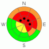
BOTTOM LINE
Danger by aspect and elevation on slopes approaching 35° or steeper.
(click HERE for tomorrow's danger rating)
|

Danger Rose Tutorial
|
At and above treeline in the wind zone a Level 4 (HIGH) avalanche danger exists. Deep, dangerous, unsurvivable human triggered avalanches are very likely, especially on steep wind drifted slopes facing the north half of the compass. Within this terrain, pockets of Level 5 (EXTREME) danger will be found. Historically large, human triggered tree snapping avalanches are certain on steep, wind loaded slopes.
A Level 3 (CONSIDERABLE) avalanche danger exists on northerly facing terrain at lower elevations and human triggered avalanches are likely on any steep snow covered slope.
Slopes facing the south half of the compass at mid and low elevations offer Level 1 (LOW) avalanche danger. |
|
|
CURRENT CONDITIONS |

|
Snow developed overnight with 2"-4" reported early this morning. Southerly winds are cranking in the 30's with gusts in the 50's along the ridges. Temperatures are balmy, in the low to mid 30's. Trailbreaking is an inverted wallowfest. |
|
|
RECENT ACTIVITY |

|
Lots of booming collapses, widespread cracking, and of course many human triggered avalanches have been reported across the range. Click here for a report of a monster slide we triggered yesterday near Mill Hollow.
Ted and Joe were along Mirror Lake Highway and saw very fragile snow there too. Click here for their observation.
Click here for recent observations. |
|
|
THREAT #1 |

|
| WHERE |
PROBABILITY |
SIZE |
TREND |
|
|
|
|
| |
|
|
Over the next
24 hours.
|
|
|
This video pretty much sums up what's going on with our snowpack. It’s no mystery…. avalanche conditions have become dangerous. Our historically weak snowpack is no match for the recent round of dense, heavy, Spring-like snow and nuking winds. Yesterday we continued to experience widespread collapsing and booming whoomphs, witnessed avalanches in unusual terrain and on slopes you’d normally go to ride on when the avalanche danger is sketchy, and of course, got to see deep, dangerous avalanches breaking to weak snow near the ground. It sounds like a complicated picture with lots of moving parts, but it’s pretty straight forward. Any steep slope that had old pre-existing snow prior to the recent storm should be considered suspect and avoided. Avalanches triggered today will be deep, dangerous, and unsurvivable. It doesn’t mean you can’t go riding. Remember- you can have a blast carving in the meadows with no steep slopes above or adjacent to where you’re riding. |
|
|
MOUNTAIN WEATHER |

|
Heavy, wet snow should fall throughout the day with 6" expected. Temperatures will be mild with highs reaching into the mid 30's. West and southwest winds will nuke in the 50's and 60's along the ridges, before a cold front arrives late this afternoon and winds switch to the northwest and mellow out. An additional 6" of snow is expected overnight. Temperatures dive into the teens by Sunday morning. |
|
|
GENERAL ANNOUNCEMENTS |
The information in this advisory expires 24 hours after the date and time posted, but will be updated by 7:00 AM Sunday, January 22nd.
If you’re getting out and about and trigger an avalanche or see anything interesting please drop me an email at
craig@utahavalanchecenter.org
or call 801-231-2170 |
|
|
This information does not apply to developed ski areas or highways where avalanche control is normally done. This advisory is from the U.S.D.A. Forest Service, which is solely responsible for its content. This advisory describes general avalanche conditions and local variations always occur. |
|
This advisory provided by the USDA Forest Service, in partnership with:
The Friends of the Utah Avalanche Center, Utah Division of State Parks and Recreation, Utah Division of Emergency Management, Salt Lake County, Salt Lake Unified Fire Authority and the friends of the La Sal Avalanche Center. See our Sponsors Page for a complete list. |
