AVALANCHE WARNING »
Dangerous avalanche conditions are occuring or are imminent.
Backcountry travel in avalanche terrain is not recommended.
|
 |
Notice: An Avalanche Warning remains in effect for the Western Uinta Mountains. Strong winds, coupled with dense, heavy snow has created a HIGH avalanche danger and human triggered avalanches are very likely. Backcountry travel is not recommended. |
|
|
SPECIAL ANNOUNCEMENT |
|
|
|
BOTTOM LINE
Danger by aspect and elevation on slopes approaching 35° or steeper.
(click HERE for tomorrow's danger rating)
|
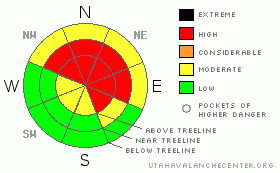
Danger Rose Tutorial
|
At and above treeline in the wind zone a Level 4 (HIGH) avalanche danger exists. Deep, dangerous and possibly unsurvivable human triggered avalanches are very likely, especially on steep wind drifted slopes facing the north half of the compass.
A Level 2 (MODERATE) avalanche danger exists at lower elevations and human triggered avalanches are possible on any steep wind drifted slope.
Slopes facing the south half of the compass at mid and low elevations offer Level 1 (LOW) avalanche danger. |
|
|
CURRENT CONDITIONS |

|
Skies are cloudy, temperatures in the upper 20’s and low 30’s and just 6” of very dense heavy snow fell throughout the region as the first wave of the big storm gets underway. South and southwest winds nuked all day Wednesday, blowing in the 50’s and 60’s, but have mellowed to 20-30 mph early this morning. |
|
|
RECENT ACTIVITY |

|
No new avalanche activity to report, but this video pretty much sums it up.
Click here for recent observations. |
|
|
THREAT #1 |

|
| WHERE |
PROBABILITY |
SIZE |
TREND |
|
|
|
|
| |
|
|
Over the next
24 hours.
|
|
|
Winds cranked all day yesterday forming a dense, cohesive, strong feeling slab which rests on a historically weak snowpack. Deep, dangerous, and possibly unsurvivable human triggered avalanches breaking to the ground are likely. Today you need to continue staying off of and out from under any steep wind drifted slope. It’s getting tricky out there and avalanches can be triggered from a distance and from low angle terrain.
These are dangerously unmanageable avalanche conditions. No, you’re not going to trigger slides on every steep slope you ride today and that’s just the problem. It’ll be easy to get lured out onto slopes before you find the right combination of strong snow overlaying weak snow, you’ll collapse the slope, and you’re off to the races.
It doesn’t mean you can’t go riding. It does mean you’re gonna have to exercise some patience. Remember- you can have a blast carving low angle meadows with no steep slopes above or adjacent to where you’re riding. |
|
|
MOUNTAIN WEATHER |

|
Snow, heavy at times, will continue through Friday. West and southwest winds are going to be a nuisance, blowing in the 20’s and 30’s with gusts in the 40’s along the ridges. Temperatures remain quite mild with highs in the low to mid 30’s. Overnight lows dip into the 20’s. A brief break in the weather is expected Friday night before another wet storm system moves through the area for Saturday. |
|
|
GENERAL ANNOUNCEMENTS |
The information in this advisory expires 24 hours after the date and time posted, but will be updated by 7:00 AM Friday, January 20th.
If you’re getting out and about and trigger an avalanche or see anything interesting please drop me an email at
craig@utahavalanchecenter.org
or call 801-231-2170 |
|
|
This information does not apply to developed ski areas or highways where avalanche control is normally done. This advisory is from the U.S.D.A. Forest Service, which is solely responsible for its content. This advisory describes general avalanche conditions and local variations always occur. |
|
This advisory provided by the USDA Forest Service, in partnership with:
The Friends of the Utah Avalanche Center, Utah Division of State Parks and Recreation, Utah Division of Emergency Management, Salt Lake County, Salt Lake Unified Fire Authority and the friends of the La Sal Avalanche Center. See our Sponsors Page for a complete list. |
