AVALANCHE WARNING »
Dangerous avalanche conditions are occuring or are imminent.
Backcountry travel in avalanche terrain is not recommended.
|
 |
Notice: An Avalanche Warning is in effect for the Western Uinta Mountains. Strong winds have increased the avalanche danger to HIGH and human triggered avalanches are very likely. As the storm unfolds during the overnight hours Wednesday and on Thursday natural avalanches will become likely. Backcountry travel is not recommended. |
|
|
SPECIAL ANNOUNCEMENT |
|
|
|
BOTTOM LINE
Danger by aspect and elevation on slopes approaching 35° or steeper.
(click HERE for tomorrow's danger rating)
|
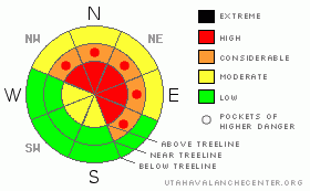
Danger Rose Tutorial
|
Above treeline in the wind zone a Level 4 (HIGH) avalanche danger exists. Deep, dangerous human triggered avalanches are very likely, especially on steep wind drifted slopes facing the north half of the compass.
At treeline a Level 3 (CONSIDERABLE) avalanche danger will be found on steep wind drifted slopes and human triggered avalanches are likely.
Slopes facing the south half of the compass at mid and low elevations offer Level 1 (LOW) avalanche danger. |
|
|
CURRENT CONDITIONS |

|
Clouds are streaming into the region as the leading edge of a strong westerly flow develops over the region. West and southwest winds are blowing 30-50 mph along the ridges and temperatures are in the upper teens and low 20’s. |
|
|
RECENT ACTIVITY |

|
Trent and I triggered a 3’ deep hard slab while walking along a low angle ridgeline near Wolf Creek Pass. Click here to view video of the slide.
Ted was over on the North Slope and found sensitive conditions too. Click here to view his trip report.
Click here for recent observations. |
|
|
THREAT #1 |

|
| WHERE |
PROBABILITY |
SIZE |
TREND |
|
|
|
|
| |
|
|
Over the next
24 hours.
|
|
|
Trent's awesome video tells it all. Avalanche conditions are rapidly changing as strong wind drifted snow overloads our usually weak snowpack. As the storm develops, deep dangerous, human triggered avalanches breaking to weak snow near the ground will become more likely. Today you need to stay off of and out from under any steep wind drifted slope. It’s getting tricky out there and avalanches can be triggered from a distance and from low angle terrain.
These are dangerously unmanageable avalanche conditions. No, you’re not going to trigger slides on every steep slope you ride today and that’s just the problem. It’ll be easy to get lured out onto slopes before you find the right combination of strong snow overlaying weak snow, you’ll collapse the slope, and you’re off to the races.
It doesn’t mean you can’t go riding. It does mean you’re gonna have to exercise some patience. Remember- you can have a blast carving low angle meadows with no steep slopes above or adjacent to where you’re riding. |
|
|
MOUNTAIN WEATHER |

|
Clouds thicken and moisture increases with snowfall expected to begin by early afternoon. West winds will crank along the ridges, blowing in the 30’s and 40’s, gusting to 70 mph along the high peaks. Temperatures climb into the mid to upper 20’s and don’t vary much overnight. It looks like the storm gets going overnight and we should see 6”-8” by Thursday morning. Snow continues through the day into Friday before a brief break late in the day. The active wet pattern resumes over the weekend. |
|
|
GENERAL ANNOUNCEMENTS |
The information in this advisory expires 24 hours after the date and time posted, but will be updated by 7:00 AM Thursday, January 19th.
If you’re getting out and about and trigger an avalanche or see anything interesting please drop me an email at
craig@utahavalanchecenter.org
or call 801-231-2170 |
|
|
This information does not apply to developed ski areas or highways where avalanche control is normally done. This advisory is from the U.S.D.A. Forest Service, which is solely responsible for its content. This advisory describes general avalanche conditions and local variations always occur. |
|
This advisory provided by the USDA Forest Service, in partnership with:
The Friends of the Utah Avalanche Center, Utah Division of State Parks and Recreation, Utah Division of Emergency Management, Salt Lake County, Salt Lake Unified Fire Authority and the friends of the La Sal Avalanche Center. See our Sponsors Page for a complete list. |
