SPECIAL ANNOUNCEMENT |
 |
Many thanks to Weller Recreation and Summit County Search and Rescue for hosting this weeks avalanche awareness presentation in Kamas. In addition, I want to thank the Weller's, BRP, and Ski-Doo for their continued support of the Avalanche Center helping to provide a loaner sled each year. Click here to see our new ride. |
|
|
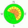
BOTTOM LINE
Danger by aspect and elevation on slopes approaching 35° or steeper.
(click HERE for tomorrow's danger rating)
|

Danger Rose Tutorial
|
At and above treeline a Level 3 (CONSIDERABLE) avalanche danger exists. Avalanches breaking within the new wind drifted snow are likely. In addition, dangerous and unmanageable avalanches that break to weak snow near the ground are also likely, especially on steep slopes facing the north half of the compass.
A LEVEL 2 (MODERATE) danger exists at mid elevations and human triggered avalanches are possible, particularly on steep wind drifted slopes.
Wind sheltered mid and low elevation slopes, along with terrain facing the south half of the compass offer Level 1 (LOW) avalanche danger. |
|
|
CURRENT CONDITIONS |

|
A quick moving cold front is just entering northern Utah and snow should start to fall in the next couple of hours. South and southwest winds continue to crank at 40 mph with gusts in the low 70’s along the high ridges. Temperatures are in the low to mid 20’s and riding conditions remain less than ideal. |
|
|
RECENT ACTIVITY |

|
No new avalanche activity to report. Click here for recent observations. |
|
|
THREAT #1 |

|
| WHERE |
PROBABILITY |
SIZE |
TREND |
|
|
|
|
| |
|
|
Over the next
24 hours.
|
|
|
New snow and gusty winds will rapidly create stiff slabs sensitive to the weight of a rider. Expect to find fresh drifts forming lower down slope than we usually see. I would avoid any steep wind drifted slope, especially if it’s fat looking, rounded, or feels hollow. Once triggered, even a shallow avalanche could break into deeper buried weak layers as it descends the slope, creating a much deeper, scarier avalanche than then you might have bargained for. |
|
|
THREAT #2 |

|
| WHERE |
PROBABILITY |
SIZE |
TREND |

|
|
|
|
| |
|
|
Over the next
24 hours.
|
|
|
Unmanageable avalanche conditions lurk closer to the ground where the strength and structure of our snowpack is a complete junk show. Each time the weak pack has experienced a sudden load this winter, we’ve seen both natural and human triggered avalanches breaking to the ground. The past two days worth of wind have put the avalanche danger into another arena. It's getting tricky out there. The snow will feel strong and solid underneath our machine, but we need to remember what we’re riding on and it’s a house of cards just waiting for someone to come along and kick the legs out.
These are dangerously unmanageable avalanche conditions. No, you’re not going to trigger slides on every steep slope you ride today and that’s just the problem. It’ll be easy to get lured out onto slopes before you find the right combination of strong snow overlaying weak snow, you’ll collapse the slope, and you’re off to the races. Triggering an avalanche today will, at the very least, result in a body beating ride through rocks and stumps. |
|
|
MOUNTAIN WEATHER |

|
A good shot of snow should move into the region early this morning, but it’s a short-lived storm with only 2”-4” of snow expected. Winds start to back off after the front arrives, they switch to the northwest and decrease this afternoon. Temperatures crash into negative territory overnight and only climb into the low 20’s on Tuesday as brief high pressure makes an appearance. Winds ramp back up late Tuesday as a series of moist storms in a westerly flow start to roll through the region. It looks like we’re in for a stormy, windy pattern that should last through the end of the week. |
|
|
GENERAL ANNOUNCEMENTS |
The information in this advisory expires 24 hours after the date and time posted, but will be updated by 7:00 AM Wednesday, January 18th.
If you’re getting out and about and trigger an avalanche or see anything interesting please drop me an email at
craig@utahavalanchecenter.org
or call 801-231-2170 |
|
|
This information does not apply to developed ski areas or highways where avalanche control is normally done. This advisory is from the U.S.D.A. Forest Service, which is solely responsible for its content. This advisory describes general avalanche conditions and local variations always occur. |
|
This advisory provided by the USDA Forest Service, in partnership with:
The Friends of the Utah Avalanche Center, Utah Division of State Parks and Recreation, Utah Division of Emergency Management, Salt Lake County, Salt Lake Unified Fire Authority and the friends of the La Sal Avalanche Center. See our Sponsors Page for a complete list. |
