SPECIAL ANNOUNCEMENT |
 |
Many thanks to Weller Recreation and Summit County Search and Rescue for hosting this weeks avalanche awareness presentation in Kamas. In addition, I want to thank the Weller's and Ski-Doo for their continued support of the Avalanche Center helping to provide a loaner sled each year. |
|
|
BOTTOM LINE
Danger by aspect and elevation on slopes approaching 35° or steeper.
(click HERE for tomorrow's danger rating)
|
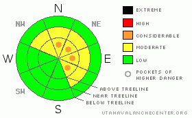
Danger Rose Tutorial
|
At and above treeline pockets of Level 3 (CONSIDERABLE) avalanche danger exist. Unmanageable avalanches breaking to weak snow near the ground are likely, especially on steep slopes facing the north half of the compass.
A LEVEL 2 (MODERATE) danger exists at mid elevations and human triggered avalanches are possible, particularly on steep wind drifted slopes.
Mid and low elevation slopes facing the south half of the compass offer Level 1 (LOW) avalanche danger. |
|
|
CURRENT CONDITIONS |

|
Skies are clear and temperatures in the low to mid 20’s. Westerly winds are blowing 15-25 mph at most ridge top locations with a few gusts in the 30’s along the highest peaks. Riding conditions are less than ideal, but it’ll be a beautiful day in the mountains none-the-less. |
|
|
RECENT ACTIVITY |

|
No new avalanche activity to report. Click here for recent observations. |
|
|
THREAT #1 |

|
| WHERE |
PROBABILITY |
SIZE |
TREND |
|
|
|
|
| |
|
|
Over the next
24 hours.
|
|
|
Weak sugary snow near the ground continues to plague the region this winter and it isn’t going away anytime soon. Of course we’re used to trophy size depth hoar, pouring through the fingers of our gloves like rock salt, but this is truly ridiculous. As a matter of fact, our current snowpack setup will only get trickier over time, especially once it starts storming again. Here’s the deal. On shady slopes at mid and low elevations it’s a complete wallowfest and you’re basically riding on the ground. As you get into wind loaded terrain at and above treeline you’ll find stronger feeling snow, but that rests on top of all this garbage… bad combination. While you’d have to really go hunting for an avalanche today, if you’re getting into steep, upper elevation terrain facing the north half of the compass, you’ll be right in the bull’s-eye. Triggering an avalanche today will, at the very least, result in a body beating ride through rocks and stumps. With all the marginal riding out there right now it’s not worth getting injured. |
|
|
MOUNTAIN WEATHER |

|
Sunny skies and temperatures warming into the low 40’s are on tap for today. High pressure starts to weaken and shift east this afternoon ahead of a cold storm slated to impact the region late Sunday night. Southwest winds increase tonight through Sunday as the cold front approaches. This is a quick hitting system with storm totals in the 3”-6” range. Snow showers taper off Monday afternoon and then a warming westerly flow develops Monday night through Tuesday stretching through the end of the week. Looks like we should see snow Wednesday through Friday, but totals are a bit vague right now. We should have a better idea for Sunday’s update. |
|
|
GENERAL ANNOUNCEMENTS |
The information in this advisory expires 24 hours after the date and time posted, but will be updated by 7:00 AM Sunday, January 15th.
If you’re getting out and about and trigger an avalanche or see anything interesting please drop me an email at
craig@utahavalanchecenter.org
or call 801-231-2170 |
|
|
This information does not apply to developed ski areas or highways where avalanche control is normally done. This advisory is from the U.S.D.A. Forest Service, which is solely responsible for its content. This advisory describes general avalanche conditions and local variations always occur. |
|
This advisory provided by the USDA Forest Service, in partnership with:
The Friends of the Utah Avalanche Center, Utah Division of State Parks and Recreation, Utah Division of Emergency Management, Salt Lake County, Salt Lake Unified Fire Authority and the friends of the La Sal Avalanche Center. See our Sponsors Page for a complete list. |
