SPECIAL ANNOUNCEMENT |
 |
Deceptively dangerous avalanche conditions exist in the western Uinta Mountains. |
|
|
BOTTOM LINE
Danger by aspect and elevation on slopes approaching 35° or steeper.
(click HERE for tomorrow's danger rating)
|
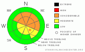
Danger Rose Tutorial
|
At and above treeline a Level 3 (CONSIDERABLE) avalanche danger exists and human triggered avalanches breaking to weak snow near the ground are likely, especially on steep slopes facing the north half of the compass.
A LEVEL 2 (MODERATE) danger exists for manageable wind slabs breaking within the new storm snow, particularly on steep wind drifted slopes.
Mid and low elevation slopes facing the south half of the compass offer Level 1 (LOW) avalanche danger. |
|
|
CURRENT CONDITIONS |

|
The North Slope picked up the bulk of yesterday’s storm and much of the terrain received 6”-8” of very light density fluff. Nearly every other snow site from Mirror Lake to Daniels is reporting just about 4”. North and northeast winds picked up for a few hours late last night, gusting into the upper 30’s, before switching more northerly and backing off into the 15-25 mph range. Under clear skies temperatures are in the low to mid single digits. |
|
|
RECENT ACTIVITY |

|
Saturday was quiet on the eastern front, but it’s been a busy week with several sled triggered slides breaking to weak snow near the ground. Click here for more details. |
|
|
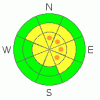
THREAT #1 |

|
| WHERE |
PROBABILITY |
SIZE |
TREND |
|
|
|
|
| |
|
|
Over the next
24 hours.
|
|
|
In the wake of yesterday’s storm winds picked up and formed sensitive, yet shallow drifts along the leeward side of upper elevation ridges. Today’s manageable soft slabs will predictably break at or below your sled, skis, or board. But that doesn’t tell the whole tale. |
|
|
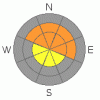
THREAT #2 |

|
| WHERE |
PROBABILITY |
SIZE |
TREND |
|
|
|
|
| |
|
|
Over the next
24 hours.
|
|
|
The unmanageable chapters of the bigger story revolve around the weak snow near the ground and the strong New Years slab that rests on top of this fragile house of cards. Usually we think of sketchy avalanche conditions when we’re breaking trail in deep snow and busting through wind drifts, not when there’s just a few inches of light density fluff sitting on a hard, solid feeling base. Today’s sunny skies and intoxicating light powder will give us a false sense of stable snow, luring us onto steep slopes thinking they’re good to go. And that’s just the problem. We need to think about not only the snow we’re riding in, but also the snow we’re riding on… and it’s a complete junk show. Yep, these are exactly the kind of days when most avalanche accidents and close calls occur.
Remember-cracking (check out this cool video), collapsing, and recent avalanche activity are huge clues to unstable snow. If you’re seeing these red flags, be flexible with your objectives for the day. Above all…. think about the consequences if you do trigger a slide and get dragged through rocks and stumps barely hidden under our shallow snowpack. It doesn’t mean you can’t ride today. You can still have a blast today carving on low angle meadows and slopes that face the south half of the compass and never even have to deal with any avalanche issues. |
|
|
MOUNTAIN WEATHER |

|
High pressure builds over the region today, giving us clear skies with daytime highs warming into the low to mid 20’s. Overnight lows dip into the low teens and single digits. Northerly winds will be brisk along the ridges, gusting into the 30’s and low 40’s. The ridge settles in over the region on Monday and we should see a jump in temperatures early in the week. A splitting storm grazes the region late Tuesday and we might see some light snow showers for Wednesday. After that quiet weather is slated for the next 7-10 days. |
|
|
GENERAL ANNOUNCEMENTS |
The information in this advisory expires 24 hours after the date and time posted, but will be updated by 7:00 AM Wednesday, January 11th.
If you’re getting out and about and trigger an avalanche or see anything interesting please drop me an email at craig@utahavalanchecenter.org or call 801-231-2170
Also, now is a great time to schedule one of our free avalanche awareness presentations for your group or club. Email or call me and we’ll get you booked before things get too crazy. |
|
|
This information does not apply to developed ski areas or highways where avalanche control is normally done. This advisory is from the U.S.D.A. Forest Service, which is solely responsible for its content. This advisory describes general avalanche conditions and local variations always occur. |
|
This advisory provided by the USDA Forest Service, in partnership with:
The Friends of the Utah Avalanche Center, Utah Division of State Parks and Recreation, Utah Division of Emergency Management, Salt Lake County, Salt Lake Unified Fire Authority and the friends of the La Sal Avalanche Center. See our Sponsors Page for a complete list. |
