AVALANCHE WARNING »
Dangerous avalanche conditions are occuring or are imminent.
Backcountry travel in avalanche terrain is not recommended.
|
 |
Notice: An Avalanche Warning has been issued for the mountains of Northern and Central Utah. Heavy snowfall on an extremely weak snowpack has created High avalanche danger. Large dangerous avalanches can be triggered on steep slopes and from a distance. Backcountry travel is not recommended. |
|
|
SPECIAL ANNOUNCEMENT |
|
|
|
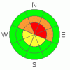
BOTTOM LINE
Danger by aspect and elevation on slopes approaching 35° or steeper.
(click HERE for tomorrow's danger rating)
|
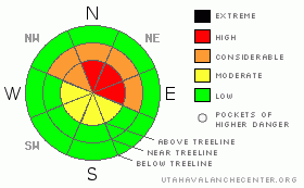
Danger Rose Tutorial
|
At and above treeline dangerous avalanche conditions exist. In the wind zone a Level 4 (HIGH) avalanche danger will be found today and human triggered avalanches breaking to weak snow near the ground are very likely.
At treeline and on any steep, mid elevation slope, especially those facing the north half of the compass, a Level 3 (CONSIDERABLE) avalanche danger exists and human triggered avalanches are likely.
Mid and low elevation slopes facing the south half of the compass offer Level 1 (LOW) avalanche danger. |
|
|
CURRENT CONDITIONS |

|
Finally, a storm to talk about. A Pacific system is just starting to slide through the region and light snow developed around 3:00 this morning. So far totals are light, just an inch or so, but we should see a nice blast of snow in the next couple of hours which will greatly improve the riding and turning conditions. Winds are still southerly, blowing 10-20 mph along the ridges and temperatures are in the low to mid 20’s. |
|
|
RECENT ACTIVITY |

|
Ted and Joe were out and about yesterday and took a look at a small sled triggered pocket in the Whitney Basin. Click here for details.
Tuesday we spotted a slide on Yamaha Hill that occurred late Monday afternoon. 1’-4’ deep and 300’ wide, the sled triggered avalanche was initiated low on the slope, breaking into weak sugary snow near the ground.Click to view images before and after the slide was triggered.
Click here for recent observations from around the range. |
|
|
THREAT #1 |

|
| WHERE |
PROBABILITY |
SIZE |
TREND |
|
|
|
|
| |
|
|
Over the next
24 hours.
|
|
|
New snow and wind will form sensitive, yet manageable avalanche conditions along the leeward side of upper elevation ridges. The unmanageable avalanches we need to focus on are the slides breaking into weak snow near the ground. In much or our mid and upper elevation leeward terrain a solid, bomber feeling wind slab formed by the New Years storm rests on top of a very fragile, sugary base. Today we’ll need to think not only about the snow we’re riding in, but also the snow we’re riding on. On steep slopes where strong snow overlies weak snow, we’re dealing with an entirely different and unmanageable avalanche dragon. Once initiated, avalanches can break into weak snow near the ground, producing a large, dangerous, and possibly unsurvivable slide. Today I would avoid steep mid and upper elevation terrain, especially slopes facing Northwest through Northeast.
Remember-cracking (check out this cool video), collapsing, and recent avalanche activity are huge clues to unstable snow. If you’re seeing these huge red flags, be flexible with your objectives for the day. Above all…. think about the consequences if you do trigger a slide and get dragged through rocks and stumps barely hidden under our shallow snowpack. It doesn’t mean you can’t ride today. You can still have a blast today carving on low angle meadows and slopes that face the south half of the compass and never even have to deal with any avalanche issues. |
|
|
MOUNTAIN WEATHER |

|
A quick shot of snow is developing and we should see 5”-10” stack up pretty rapidly once the core of the storm arrives a little later this morning. West and northwesterly winds should bump up for a few hours this morning as well, and gust in the 30’s and 40’s along the high ridges, before backing off by about lunch time. Temperatures should be dropping into the upper teens and low 20’s as the front passes by. Overnight lows will be in the single digits. Partly cloudy skies are expected for Sunday as high pressure builds, with rapidly warming temperatures on tap tomorrow afternoon and Monday. |
|
|
GENERAL ANNOUNCEMENTS |
The information in this advisory expires 24 hours after the date and time posted, but will be updated by 7:00 AM Sunday, January 8th.
If you’re getting out and about and trigger an avalanche or see anything interesting please drop me an email at craig@utahavalanchecenter.org or call 801-231-2170
Also, now is a great time to schedule one of our free avalanche awareness presentations for your group or club. Email or call me and we’ll get you booked before things get too crazy. |
|
|
This information does not apply to developed ski areas or highways where avalanche control is normally done. This advisory is from the U.S.D.A. Forest Service, which is solely responsible for its content. This advisory describes general avalanche conditions and local variations always occur. |
|
This advisory provided by the USDA Forest Service, in partnership with:
The Friends of the Utah Avalanche Center, Utah Division of State Parks and Recreation, Utah Division of Emergency Management, Salt Lake County, Salt Lake Unified Fire Authority and the friends of the La Sal Avalanche Center. See our Sponsors Page for a complete list. |
