SPECIAL ANNOUNCEMENT |
 |
A Special Avalanche Advisory continues for the mountains of Northern and Central Utah. Dangerous avalanche conditions exist. Large avalanches can easily be triggered by people on steep, wind drifted slopes and from a distance. Backcountry travel in steep avalanche terrain is not recommended. |
|
|
BOTTOM LINE
Danger by aspect and elevation on slopes approaching 35° or steeper.
(click HERE for tomorrow's danger rating)
|
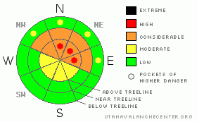
Danger Rose Tutorial
|
At and above treeline dangerous avalanche conditions exist. In the wind zone pockets of Level 4 (HIGH) avalanche danger will be found today and human triggered avalanches breaking to weak snow near the ground are likely.
At treeline and on any steep, mid elevation slope, especially those facing the north half of the compass, a Level 3 (CONSIDERABLE) avalanche danger exists.
Mid and low elevation slopes facing the south half of the compass offer Level 1 (LOW) avalanche danger. |
|
|
CURRENT CONDITIONS |

|
Happy New Year! In the wake of yesterday’s storm, skies are clear, west and northwest winds have relaxed to 15-25 mph, and temperatures are in the upper teens and low 20’s. It’s hard to say exactly how much snow fell out of the sky, but reports of 4” seem to be pretty accurate. Riding and turning conditions have hardly improved and our snowpack remains miserably thin and weak. |
|
|
RECENT ACTIVITY |

|
Collapsing, loud booming whoomphs, and avalanches triggered from a distance were the norm yesterday. Click here for Ted’s great report from Elizabeth Peak where two slides were reported Friday. Both slides occurred on east facing slopes and both broke to the dirt. Fortunately no one was caught.
Click here for recent observations from around the range. |
|
|
THREAT #1 |

|
| WHERE |
PROBABILITY |
SIZE |
TREND |

|
|
|
|
| |
|
|
Over the next
24 hours.
|
|
|
Avalanche conditions remain tricky and dangerous today. As a matter of fact, they’re downright spooky. Our fragile snowpack is about the weakest I’ve ever seen and now we’ve added a dense, cohesive wind slab on top of this mess. This isn’t like our ordinary winters where you give it a day or two, things settle out and then it’s good to go. Persistent weaknesses like we’re dealing with take a long time to heal, remaining suspect for days and sometimes even weeks after a storm. (Click here to view a video explaining the sketchy setup). These are exactly the type of conditions that trick most experienced riders and exactly the type of conditions when most avalanche accidents occur. Whoomphing, collapsing, shooting cracks, and avalanches are your biggest clues to unstable snow. Take a minute and look around and make informed decisions. If you’re seeing these huge red flags, be flexible with your objectives for the day. Above all…. think about the consequences if you do trigger a slide and get dragged through rocks and stumps barely hidden under our shallow snowpack. It doesn’t mean you can’t ride today. It does mean you’re gonna have to tone it down, exercise patience, and avoid being on or connected to steep slopes, especially those with recent deposits of wind drifted snow. |
|
|
MOUNTAIN WEATHER |

|
Well, you probably already figured this one out…. high pressure is building for the week and we should see clear skies and warming temperatures. Winds will be variable and blowing 10-20 mph along the ridges. High temperatures climb into the mid and upper 30’s with overnight lows in the teens. The next best shot of snow looks to be next weekend. |
|
|
GENERAL ANNOUNCEMENTS |
The information in this advisory expires 24 hours after the date and time posted, but will be updated by 7:00 AM Wednesday, January 4th.
If you’re getting out and about and trigger an avalanche or see anything interesting please drop me an email at craig@utahavalanchecenter.org or call 801-231-2170
Also, now is a great time to schedule one of our free avalanche awareness presentations for your group or club. Email or call me and we’ll get you booked before things get too crazy. |
|
|
This information does not apply to developed ski areas or highways where avalanche control is normally done. This advisory is from the U.S.D.A. Forest Service, which is solely responsible for its content. This advisory describes general avalanche conditions and local variations always occur. |
|
This advisory provided by the USDA Forest Service, in partnership with:
The Friends of the Utah Avalanche Center, Utah Division of State Parks and Recreation, Utah Division of Emergency Management, Salt Lake County, Salt Lake Unified Fire Authority and the friends of the La Sal Avalanche Center. See our Sponsors Page for a complete list. |
