SPECIAL ANNOUNCEMENT |
 |
Thanks to Ted Scroggin, our Uinta weather station network is up and running. Click here for winds, temperatures, and snowfall.... or lack there of.
Plowing on the Mirror Lake Highway is done for the season, Wolf Creek Pass is driveable with a few slick spots.
|
|
|
BOTTOM LINE
Danger by aspect and elevation on slopes approaching 35° or steeper.
(click HERE for tomorrow's danger rating)
|
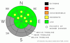
Danger Rose Tutorial
|
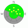
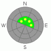
At and above treeline, pockets of Level 2 (Moderate) avalanche danger exist and today we’re dealing with two distinctly different avalanche problems. Human triggered loose snow avalanches are possible, especially on sustained steep slopes facing the north half of the compass. At upper elevations in the wind zone, human triggered avalanches are possible especially on steep slopes with both old and recent deposits of wind drifted snow. While more the exception than the rule, avalanches can break into deeper buried weak layers creating a much larger slide than you might have bargained for.
Out of the wind and at lower elevations the avalanche danger is generally a Level 1 (Low) danger. |
|
|
CURRENT CONDITIONS |

|
A westerly flow over the region is ushering in clouds and warm temperatures in the mid to upper 20’s. West and southwest winds have been blowing all night in the 20’s and 30’s, but bumped up into the mid 40’s along the high ridges early this morning. Riding and turning conditions are pretty grim, though among the bottomless facets and wind worked snow you can still find swaths of soft settled snow in wind sheltered terrain. |
|
|
RECENT ACTIVITY |

|
Trent and I stomped around Wolf Creek Pass yesterday and found a mixed bag of snow conditions. Click here for observations from the area.
Click here for recent observations from around the range. |
|
|
THREAT #1 |

|
| WHERE |
PROBABILITY |
SIZE |
TREND |
|
|
|
|
| |
|
|
Over the next
24 hours.
|
|
|
The overall lack of snow this winter has made our snowpack insanely weak. In a large majority of our terrain snow depths only average 12”-18” and the snow is so loose and sugary, you’re literally riding on the ground…. what a way to run a winter! Yesterday, we were able to trigger long running facet sluffs on slopes with a sustained pitch of about 37 degrees in steepness. While not terribly dangerous, these loose snow slides can knock you off your feet and slam you into a group of trees. Once winter decides to make an appearance avalanche conditions will get dangerous in a hurry. |
|
|
THREAT #2 |

|
| WHERE |
PROBABILITY |
SIZE |
TREND |
|
|
|
|
| |
|
|
Over the next
24 hours.
|
|
|
We found isolated slabs at upper elevations that were reactive to our snowpit tests, though you’d really have to go out of your way to trigger one of these. However, if you’re getting into steep upper elevation terrain take a minute or two and tweak small test slopes similar in aspect, elevation, and slope angle and see how they’re reacting before getting after it. Given all the obstacles you’d have to deal with, triggering even a small slide would result in a body beating ride. |
|
|
MOUNTAIN WEATHER |

|
Today we can expect mostly cloudy skies with a stray snow flurry or two. Westerly winds will average 25 mph with a few gusts in the 40’s along the high ridges. Temperatures climb into the mid 30’s before diving into the 20’s overnight. Look for similar weather on Thursday, then partly cloudy skies and warmer temperatures for Friday. There’s a remote possibility for some light snow Friday night into Saturday, but dry conditions follow for the weekend and there are no big storms in sight. |
|
|
GENERAL ANNOUNCEMENTS |
The information in this advisory expires 24 hours after the date and time posted, but will be updated by 7:00 AM Saturday, December 31st.
If you’re getting out and about and trigger an avalanche or see anything interesting please drop me an email at craig@utahavalanchecenter.org or call 801-231-2170
Also, now is a great time to schedule one of our free avalanche awareness presentations for your group or club. Email or call me and we’ll get you booked before things get too crazy. |
|
|
This information does not apply to developed ski areas or highways where avalanche control is normally done. This advisory is from the U.S.D.A. Forest Service, which is solely responsible for its content. This advisory describes general avalanche conditions and local variations always occur. |
|
This advisory provided by the USDA Forest Service, in partnership with:
The Friends of the Utah Avalanche Center, Utah Division of State Parks and Recreation, Utah Division of Emergency Management, Salt Lake County, Salt Lake Unified Fire Authority and the friends of the La Sal Avalanche Center. See our Sponsors Page for a complete list. |
