SPECIAL ANNOUNCEMENT |
 |
Thanks to Ted Scroggin, our Uinta weather station network is up and running. Click here for winds, temperatures, and snowfall.... or lack there of.
Plowing on the Mirror Lake Highway is done for the season, maintenance on Wolf Creek Pass continues. In either case, be aware the Uinta snowpack is much weaker than you might find in neighboring mountains.
|
|
|
BOTTOM LINE
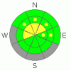
Danger by aspect and elevation on slopes approaching 35° or steeper.
(click HERE for tomorrow's danger rating)
|
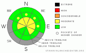
Danger Rose Tutorial
|
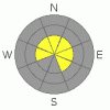
In the wind zone at and above treeline, a Level 2 (Moderate) avalanche danger exists. Human triggered avalanches are possible, especially on steep slopes with recent deposits of wind drifted snow. In addition, avalanches can break into deeper buried weak layers, creating a much larger slide than you might have bargained for.
Out of the wind and at lower elevations the avalanche danger is generally a Level 1 (Low) danger. |
|
|
CURRENT CONDITIONS |

|
Merry Christmas! High pressure over the region is giving us clear skies and temperatures in the low to mid 20’s. North and northeast winds bumped up into the 20’s and 30’s overnight, but backed off early this morning and are in the teens and low 20’s along the ridges. Among the rocks and obstacles barely camouflaged by the thin snowpack, you’ll find patches of soft settled powder. |
|
|
RECENT ACTIVITY |

|
Ted and Joe were out and about Friday in the Whitney Basin and spotted a few shallow soft slabs that ran during the storm. Click here for their observations.
Click here for recent observations from around the range. |
|
|
THREAT #1 |

|
| WHERE |
PROBABILITY |
SIZE |
TREND |
|
|
|
|
| |
|
|
Over the next
24 hours.
|
|
|
Wind drifts are going to be today’s most obvious and easily avoidable avalanche concern. Formed along the leeward side of upper elevation ridges and around terrain features like chutes and gullies, the slabs will appear fat and rounded. Due to an unusual easterly component to our recent winds, look for atypical drifting patterns, especially on west facing slopes. |
|
|
THREAT #2 |

|
| WHERE |
PROBABILITY |
SIZE |
TREND |
|
|
|
|
| |
|
|
Over the next
24 hours.
|
|
|
While no avalanches broke into weak snow near the ground during the recent storm, it doesn’t mean our problem child has magically vanished. If anything it’ll continue to get trickier with each successive storm. The fact is… our snowpack is miserably thin and weak and the basic structure remains suspect.. Sure, you’d really have to go out of your way to trigger a slide that breaks to the ground. However, if you’re getting into steeper terrain the next few days think of the consequences of triggering even a small slide. A season ending injury may be the least of your concerns. |
|
|
MOUNTAIN WEATHER |

|
Today we can expect sunny skies with temperatures warming into the upper 30’s. Winds will remain light and variable, but should increase somewhat tonight as a weak system grazes the area. The ridge breaks down early this week allowing a series of impulses to finally work their way into the northern half of the region. The next best chance of snow will be Wednesday. |
|
|
GENERAL ANNOUNCEMENTS |
The information in this advisory expires 24 hours after the date and time posted, but will be updated by 7:00 AM Wednesday, December 28th.
If you’re getting out and about and trigger an avalanche or see anything interesting please drop me an email at craig@utahavalanchecenter.org or call 801-231-2170
Also, now is a great time to schedule one of our free avalanche awareness presentations for your group or club. Email or call me and we’ll get you booked before things get too crazy. |
|
|
This information does not apply to developed ski areas or highways where avalanche control is normally done. This advisory is from the U.S.D.A. Forest Service, which is solely responsible for its content. This advisory describes general avalanche conditions and local variations always occur. |
|
This advisory provided by the USDA Forest Service, in partnership with:
The Friends of the Utah Avalanche Center, Utah Division of State Parks and Recreation, Utah Division of Emergency Management, Salt Lake County, Salt Lake Unified Fire Authority and the friends of the La Sal Avalanche Center. See our Sponsors Page for a complete list. |
