SPECIAL ANNOUNCEMENT |
 |
Plowing on the Mirror Lake Highway is done for the season, maintenance on Wolf Creek Pass continues. In either case, be aware the Uinta snowpack is much weaker than you might find in neighboring mountains to the east.
|
|
|
BOTTOM LINE
Danger by aspect and elevation on slopes approaching 35° or steeper.
(click HERE for tomorrow's danger rating)
|
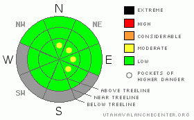
Danger Rose Tutorial
|
In the wind zone at and above treeline, pockets of Level 2 (Moderate) avalanche danger exist in steep, leeward, upper elevation terrain. Human triggered avalanches are possible, especially on slopes with recent deposits of wind drifted snow.
Out of the wind and at lower elevations the avalanche danger is generally a Level 1 (Low) danger. |
|
|
CURRENT CONDITIONS |

|
High pressure continues to dominate our weather pattern. Above the valley muck, clear skies, relatively warm temperatures, and light winds are what you’ll find. Currently, temperatures are in the mid teens at the trailheads and low to mid 20’s at 10,000’…. same as it is in Salt Lake. Northeasterly winds are light at most locations, but along the highest peaks they’re blowing 10-20 mph. A few minor systems this week gave us a couple inches of snow, but it was little to help our meager snowpack which only totals 12”-20” in depth. It’s thin and rocky out there and with no big storms on the horizon, riding options are becoming more limited. |
|
|
RECENT ACTIVITY |

|
In late breaking news…. Ted took a look at an avalanche triggered by a group of sledders in the Millcreek area on Dec. 8th. Unfortunately this slide was just recently reported to us. While it’s kind of old news, it is a sign of bigger things to come once winter kicks in. Click here to view Ted’s report.
Click here for recent observations from around the range. |
|
|
THREAT #1 |

|
| WHERE |
PROBABILITY |
SIZE |
TREND |
|
|
|
|
| |
|
|
Over the next
24 hours.
|
|
|
Our snowpack is very weak and fragile and all it takes is a little new snow and wind to get things interesting. While only a few inches of light density snow fell this week, there were some gusty upper elevation winds that created shallow drifts along the leeward side of the high ridges. You really have to go out of your way to trigger one of these today, but none-the-less, continue to look for and avoid any fat, rounded pillow of wind drifted snow. In addition, be aware of the consequences once a slab does crack out underneath you. Triggering even a small slide will result in a body bruising ride through rocks, stumps, and downed timber barely hidden under our thin snowpack. |
|
|
MOUNTAIN WEATHER |

|
Not much is changing in the weather department. High pressure remains in control of our weather for the foreseeable future. Clear skies are on tap for today and tomorrow with highs reaching into the mid and upper 30’s. Overnight lows dip into the teens. Winds should remain relatively calm and variable, blowing 10-20 mph along the ridges. A weak system on Monday cools temperatures by about ten degrees before the ridge rebounds for mid week. Our next best chance of snow will be on Thursday, but even this storm looks like it will dive well south of the region. |
|
|
GENERAL ANNOUNCEMENTS |
The information in this advisory expires 24 hours after the date and time posted, but will be updated by 7:00 AM Sunday, December 18th.
If you’re getting out and about and trigger an avalanche or see anything interesting please drop me an email at craig@utahavalanchecenter.org or call 801-231-2170
Also, now is a great time to schedule one of our free avalanche awareness presentations for your group or club. Email or call me and we’ll get you booked before things get too crazy. |
|
|
This information does not apply to developed ski areas or highways where avalanche control is normally done. This advisory is from the U.S.D.A. Forest Service, which is solely responsible for its content. This advisory describes general avalanche conditions and local variations always occur. |
|
This advisory provided by the USDA Forest Service, in partnership with:
The Friends of the Utah Avalanche Center, Utah Division of State Parks and Recreation, Utah Division of Emergency Management, Salt Lake County, Salt Lake Unified Fire Authority and the friends of the La Sal Avalanche Center. See our Sponsors Page for a complete list. |
