SPECIAL ANNOUNCEMENT |
 |
Many thanks to all who attended last night’s fundraiser at The Edge. While I couldn’t personally make it due to a prior commitment, I do know Matt Potratz story of survival is truly inspiring and I want to thank him for taking time out of his busy life to help support the UAC and keep fellow riders safe.
Plowing on the Mirror Lake Highway is done for the season, maintenance on Wolf Creek Pass continues. In either case, be aware the Uinta snowpack is much weaker than you might find in neighboring mountains to the east.
|
|
|
BOTTOM LINE
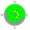
Danger by aspect and elevation on slopes approaching 35° or steeper.
(click HERE for tomorrow's danger rating)
|
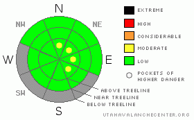
Danger Rose Tutorial
|
In the wind zone at and above treeline, pockets of Level 2 (Moderate) avalanche danger exist in steep, leeward, upper elevation terrain. Human triggered avalanches are possible, especially on slopes with recent deposits of wind drifted snow.
Out of the wind and at lower elevations the avalanche danger is generally a Level 1 (Low) danger. |
|
|
CURRENT CONDITIONS |

|
Skies are partly cloudy, temperatures are in the upper teens and low 20’s, and just an inch or two of very light density snow fell in the past 24 hours. At most locations, west and northwest winds are in the 5-15 mph range, but bumped into the 20’s and low 30’s along the high ridges early this morning. Riding and turning conditions are slightly improved, but in general our snowpack is very shallow and travel is limited to low angle meadows and rock free roads. |
|
|
RECENT ACTIVITY |

|
No new avalanche activity to report.
Click here for recent observations from around the range. |
|
|
THREAT #1 |

|
| WHERE |
PROBABILITY |
SIZE |
TREND |
|
|
|
|
| |
|
|
Over the next
24 hours.
|
|
|
With a spike in the winds and snow available for transport, avalanche conditions have changed, and today you’ll be able to trigger shallow soft slabs along the leeward side of upper elevation ridges. Don’t let the meager storm totals fool you. Even though only a few inches of light fluffy snow fell, the old snow surface is very weak and today’s wind drifts will be sensitive to the additional weight of a rider. Look for and avoid fresh drifts along the leeward side of ridges and also in upper elevation chutes and gullies. Triggering even a small slide will result in a body bruising ride through rocks, stumps, and downed timber barely hidden under our thin snowpack. |
|
|
MOUNTAIN WEATHER |

|
High pressure is building over the region, giving us partly cloudy skies and cool temperatures. West and northwest winds will be brisk, gusting into the 30’s and low 40’s along the high peaks. Temperatures don’t vary much from where we’re at this morning and overnight lows dip into the low teens. Increasing clouds are on tap for Thursday and then another storm system dives south of the region late in the day through Friday. Little if any snow is anticipated. Looking down the pike… there are no big weather pattern changes in store. |
|
|
GENERAL ANNOUNCEMENTS |
The information in this advisory expires 24 hours after the date and time posted, but will be updated by 7:00 AM Saturday, December 17th.
If you’re getting out and about and trigger an avalanche or see anything interesting please drop me an email at craig@utahavalanchecenter.org or call 801-231-2170
Also, now is a great time to schedule one of our free avalanche awareness presentations for your group or club. Email or call me and we’ll get you booked before things get too crazy. |
|
|
This information does not apply to developed ski areas or highways where avalanche control is normally done. This advisory is from the U.S.D.A. Forest Service, which is solely responsible for its content. This advisory describes general avalanche conditions and local variations always occur. |
|
This advisory provided by the USDA Forest Service, in partnership with:
The Friends of the Utah Avalanche Center, Utah Division of State Parks and Recreation, Utah Division of Emergency Management, Salt Lake County, Salt Lake Unified Fire Authority and the friends of the La Sal Avalanche Center. See our Sponsors Page for a complete list. |
