SPECIAL ANNOUNCEMENT |
 |
A huge thanks to Rick Lindsey for generously donating his time and more importantly his XInsurance winged chariot. Rick helped get us to the Windy Peak weather station in style to perform some much needed repairs after the big wind storm two weeks ago. Click here to see Craig’s other new ride.
Plowing on the Mirror Lake Highway is done for the season, maintenance on Wolf Creek Pass continues. In either case, be aware the Uinta snowpack is much weaker than you might find in neighboring mountains to the east.
The Edge Motorsports & UCrew are hosting Matt Potratz as a fundraiser for the Utah Avalanche Center: Tues Dec 13, 7:00 pm @ the Edge, 14301 S Minuteman Dr in Draper. Check out a great movie, support the UAC, and talk riding. There is a ton of donated gear for raffle and auction. Click here for more details.
|
|
|
BOTTOM LINE
Danger by aspect and elevation on slopes approaching 35° or steeper.
(click HERE for tomorrow's danger rating)
|
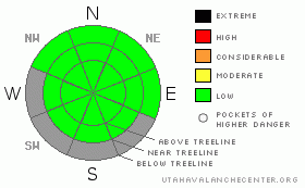
Danger Rose Tutorial
|
Level 1 (Low) avalanche danger exists in most of the terrain throughout the western Uinta’s. |
|
|
CURRENT CONDITIONS |

|
A southwesterly flow is developing over the region as a storm system dives to the southern half of the state. West and southwest winds are blowing 15-25 mph along the ridges and temperatures are inverted, in the low to mid 20’s at the higher elevations and in the low teens at the trailheads. Lack of a consistent storm track has taken its toll on our snowpack. Rock free road rides and grassy, low angle meadows are the only options. |
|
|
RECENT ACTIVITY |

|
No new avalanche activity to report.
Click here for recent observations from around the range. |
|
|
THREAT #1 |

|
| WHERE |
PROBABILITY |
SIZE |
TREND |

|
|
|
|
| |
|
|
Over the next
24 hours.
|
|
|
Our shallow snowpack continues to weaken and in many areas it has lost all supportability…. now we’re riding on the ground. For the moment the avalanche danger is generally low and the biggest danger is slamming into a buried obstacle barely hidden under this façade of snow. Remember- Low danger doesn't mean No danger and even a small avalanche will take you for a nasty ride through rocks and stumps barely hidden under the thin snowpack. |
|
|
MOUNTAIN WEATHER |

|
Most of today’s storm energy dives well to the south of the region and the only result we’ll see is an increase in high clouds throughout the day. Southwest winds blow in the 10-20 mph range with a few gusts in the 30’s along the high peaks. Temperatures climb into the mid 30’s before diving into the teens overnight. High pressure builds for early in the week and the next shot at accumulating snow looks to come late Thursday into Friday. At this time confidence is low that this will be a big snow producer. |
|
|
GENERAL ANNOUNCEMENTS |
The information in this advisory expires 24 hours after the date and time posted, but will be updated by 7:00 AM Wednesday, December 14th.
If you’re getting out and about and trigger an avalanche or see anything interesting please drop me an email at craig@utahavalanchecenter.org or call 801-231-2170
Also, now is a great time to schedule one of our free avalanche awareness presentations for your group or club. Email or call me and we’ll get you booked before things get too crazy. |
|
|
This information does not apply to developed ski areas or highways where avalanche control is normally done. This advisory is from the U.S.D.A. Forest Service, which is solely responsible for its content. This advisory describes general avalanche conditions and local variations always occur. |
|
This advisory provided by the USDA Forest Service, in partnership with:
The Friends of the Utah Avalanche Center, Utah Division of State Parks and Recreation, Utah Division of Emergency Management, Salt Lake County, Salt Lake Unified Fire Authority and the friends of the La Sal Avalanche Center. See our Sponsors Page for a complete list. |
