SPECIAL ANNOUNCEMENT |
 |
Huge thanks to Tri-City Performance and Polaris for continuing their amazing support of the Utah Avalanche Center... you guys... and gals, rock! Click here to see Craig's new ride.
Plowing on the Mirror Lake Highway is done for the season and it's going to be a mess today. Maintenance on Wolf Creek Pass continues. In either case, be aware the Uinta snowpack is much weaker than you might find in neighboring mountains to the east. |
|
|
BOTTOM LINE
Danger by aspect and elevation on slopes approaching 35° or steeper.
(click HERE for tomorrow's danger rating)
|

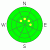
Danger Rose Tutorial
|
Level 1 (Low) avalanche danger exists in most of the terrain throughout the western Uinta’s. However, in the wind zone above treeline, you’ll find pockets of Level 2 (Moderate) avalanche danger on steep wind drifted slopes and human triggered avalanches are possible. |
|
|
CURRENT CONDITIONS |

|
High pressure firmly entrenched over the region is producing stagnant conditions at most valley locations, but up in the mountains the air is warm and skies are clear. Currently, temperatures are in the mid teens at the trailheads and in the low to mid 20’s at 10,000’. Northerly winds are blowing 15-25 mph along the high ridges. While it’s a great day to get out of the inversion, riding and turning conditions remain pretty grim.
|
|
|
RECENT ACTIVITY |

|
A few shallow wind drifts were intentionally triggered on safe test slopes in high elevation, leeward terrain. Click here for Ted's trip report from Bald Mountain Pass yesterday.
Click here for recent observations from around the range. |
|
|
THREAT #1 |

|
| WHERE |
PROBABILITY |
SIZE |
TREND |
|
|
|
|
| |
|
|
Over the next
24 hours.
|
|
|
There may still be a sensitive wind slab or two lurking in high elevation leeward terrain, but given the overall lack of snow coverage, it’s getting more difficult to get into trouble. However, if you’re venturing into upper elevation terrain today you’ll want to avoid any steep slope with recent deposits of wind drifted snow. Remember- even a small avalanche will take you for a nasty ride through rocks and stumps barely hidden under the thin snowpack. |
|
|
THREAT #2 |

|
| WHERE |
PROBABILITY |
SIZE |
TREND |

|
|
|
|
| |
|
|
Over the next
24 hours.
|
|
|
Cold clear weather has taken its toll on our shallow snowpack and it continues to grow weaker overtime. This is bad news because once it does start storming avalanche conditions will get quite tricky. In the mean time though, we’re in a holding pattern and you’d really have to go out of your way to trigger a slide that breaks to old snow near the ground. |
|
|
MOUNTAIN WEATHER |

|
Sunny skies, warm temperatures, and light winds are on tap for today. Highs reach into the low to mid 30’s and northwesterly winds blow 10-20 mph along the ridges. A weak disturbance brushes the region on Thursday producing a flurry or two, before high pressure builds for the latter half of the week. There are no big storms in sight. |
|
|
GENERAL ANNOUNCEMENTS |
The information in this advisory expires 24 hours after the date and time posted, but will be updated by 7:00 AM Saturday, December 10th.
If you’re getting out and about and trigger an avalanche or see anything interesting please drop me an email at craig@utahavalanchecenter.org or call 801-231-2170
Also, now is a great time to schedule one of our free avalanche awareness presentations for your group or club. Email or call me and we’ll get you booked before things get too crazy. |
|
|
This information does not apply to developed ski areas or highways where avalanche control is normally done. This advisory is from the U.S.D.A. Forest Service, which is solely responsible for its content. This advisory describes general avalanche conditions and local variations always occur. |
|
This advisory provided by the USDA Forest Service, in partnership with:
The Friends of the Utah Avalanche Center, Utah Division of State Parks and Recreation, Utah Division of Emergency Management, Salt Lake County, Salt Lake Unified Fire Authority and the friends of the La Sal Avalanche Center. See our Sponsors Page for a complete list. |
