SPECIAL ANNOUNCEMENT |
 |
Huge thanks to Tri-City Performance and Polaris for continuing their amazing support of the Utah Avalanche Center... you guys... and gals, rock! Click here to see Craig's new ride.
Plowing on the Mirror Lake Highway is done for the season and it's going to be a mess today. Maintenance on Wolf Creek Pass continues. In either case, be aware the Uinta snowpack is much weaker than you might find in neighboring mountains to the east. |
|
|
BOTTOM LINE
Danger by aspect and elevation on slopes approaching 35° or steeper.
(click HERE for tomorrow's danger rating)
|
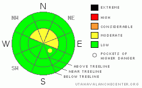
Danger Rose Tutorial
|
At and above treeline a Level 2 (Moderate) avalanche danger exists and human triggered avalanches are possible on steep wind drifted slopes. While more the exception than the rule, avalanches breaking into old snow are still possible, particularly on steep upper elevation northwest, north, northeast facing slopes.
A Level 1 (Low) avalanche danger will be found at lower elevations out of the wind, on southerly facing terrain, and on slopes that had no snow prior to early November storms. |
|
|
CURRENT CONDITIONS |

|
A cold system dropping out of the north is producing light snow and cold temperatures. Currently, it’s in the single digits and low teens with northwest winds blowing 20-30 mph along the high ridges. Not much has improved on the riding front, but you can squeak out a road ride or a few turns in a rock free meadow. Click here to view Teds trip report from Whitney Basin on Friday. |
|
|
RECENT ACTIVITY |

|
No new avalanches to report.
Click here for recent observations from around the range. |
|
|
THREAT #1 |

|
| WHERE |
PROBABILITY |
SIZE |
TREND |
|
|
|
|
| |
|
|
Over the next
24 hours.
|
|
|
The drifts from Thursday’s hurricane force wind event have relaxed, but today there’s a whole new round of fresh wind slabs. Manageable in size and easy to detect, today’s slabs are found on the leeward side of upper elevation ridges. While it’s challenging just getting into terrain where you could trigger a slide, the body beating consequences remain every bit as severe. |
|
|
THREAT #2 |

|
| WHERE |
PROBABILITY |
SIZE |
TREND |

|
|
|
|
| |
|
|
Over the next
24 hours.
|
|
|
Not much has changed with our deeper snowpack issues, but you’d really have to go out of your way to trigger an avalanche that breaks into old snow near the ground. Of course, that doesn’t mean our problems have magically healed and gone away. It does mean we have an unusually shallow snowpack for this time of year and shallow snowpacks are dangerous snowpacks. Once the winter switch is thrown into the “on” position it’s going to get very tricky. In the mean time… steep, rocky, upper elevation terrain, facing the north half of the compass are likely suspects where you could initiate a slide that fractures deeper than you might expect. |
|
|
MOUNTAIN WEATHER |

|
Snow develops after sunrise and a few quick hitting bursts should stack up 4”-6” by the end of the day. Northerly winds gust into the 30’s and 40’s along the ridges, making for a cold day with highs only reaching into the upper teens and overnight lows crashing to -10 degrees. Skies clear overnight as high pressure starts to rebound through the upcoming week. A slow warming trend with mostly sunny skies is on tap for the next few days. The future storm track looks bleak with no big changes in sight. |
|
|
GENERAL ANNOUNCEMENTS |
The information in this advisory expires 24 hours after the date and time posted, but will be updated by 7:00 AM Wednesday, December 7th.
If you’re getting out and about and trigger an avalanche or see anything interesting please drop me an email at craig@utahavalanchecenter.org or call 801-231-2170
Also, now is a great time to schedule one of our free avalanche awareness presentations for your group or club. Email or call me and we’ll get you booked before things get too crazy. |
|
|
This information does not apply to developed ski areas or highways where avalanche control is normally done. This advisory is from the U.S.D.A. Forest Service, which is solely responsible for its content. This advisory describes general avalanche conditions and local variations always occur. |
|
This advisory provided by the USDA Forest Service, in partnership with:
The Friends of the Utah Avalanche Center, Utah Division of State Parks and Recreation, Utah Division of Emergency Management, Salt Lake County, Salt Lake Unified Fire Authority and the friends of the La Sal Avalanche Center. See our Sponsors Page for a complete list. |
