SPECIAL ANNOUNCEMENT |
 |
Plowing on the Mirror Lake Highway is done for the season and it's a mess near Bald Mountain Pass. Maintenance on Wolf Creek Pass continues. In either case, be aware the Uinta snowpack is much weaker than you might find in the central Wasatch.
|
|
|
BOTTOM LINE
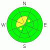
Danger by aspect and elevation on slopes approaching 35° or steeper.
(click HERE for tomorrow's danger rating)
|

Danger Rose Tutorial
|
At and above treeline a Level 2 (Moderate) avalanche danger exists and human triggered avalanches are possible on steep wind drifted slopes. Due to the odd easterly wind direction, expect to find drifting in unusual locations. While more the exception than the rule, avalanches breaking into old snow are still possible, particularly on steep upper elevation northwest, north, northeast facing slopes.
A Level 1 (Low) avalanche danger will be found at lower elevations out of the wind, on southerly facing terrain, and on slopes that had no snow prior to early November storms. |
|
|
CURRENT CONDITIONS |

|
A weak disturbance dropping into northern Utah is producing a few clouds this morning and a stray snow shower or two. A whopping inch of new snow has fallen in the past 24 hours and temperatures are in the single digits and low to mid teens. North and northeast winds are blowing 10-20 mph along the ridges. Riding or turning options remain limited to grassy meadows or rock free roads. Click here to view Teds trip report from Whitney Basin yesterday. |
|
|
RECENT ACTIVITY |

|
No new avalanches to report.
Click here for recent observations from around the range. |
|
|
THREAT #1 |

|
| WHERE |
PROBABILITY |
SIZE |
TREND |
|
|
|
|
| |
|
|
Over the next
24 hours.
|
|
|
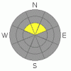
The western Uinta’s didn’t escape the wrath of Thursday’s ridiculous wind event adding insult to injury, sculpting our upper elevation terrain into a windswept mess. Now, a cohesive slab rests on weak, sugary snow and slopes are collapsing with the additional weight of a rider. While it’s challenging just getting into terrain where you could trigger a slide, the consequences remain every bit as severe. In addition, because of the easterly component to the winds, drifts formed in unusual locations and on slopes with a westerly aspect. In any case, today you’ll want to look for and avoid steep, upper elevation terrain, especially slopes with recent deposits of wind drifted snow. |
|
|
THREAT #2 |

|
| WHERE |
PROBABILITY |
SIZE |
TREND |
|
|
|
|
| |
|
|
Over the next
24 hours.
|
|
|
You’d really have to go out of your way to trigger an avalanche that breaks into old snow near the ground, but that doesn’t mean our problems have magically healed and gone away. It does mean we have an unusually shallow snowpack for this time of year and shallow snowpacks are dangerous snowpacks. Once the winter switch is thrown into the “on” position it’s going to get very tricky. In the mean time… steep, rocky, upper elevation terrain, facing the north half of the compass are likely suspects where you could initiate a slide that fractures deeper than you might expect. |
|
|
MOUNTAIN WEATHER |

|
A weak storm system grazes the region this morning with a few flurries expected, then clearing skies by about lunch time. North and northeast winds blow 10-20 mph. along the ridges which will make for a chilly day with highs only reaching into the mid teens. Overnight lows dive into the single digits as another cold, yet dry system bumps through the area for Sunday. Cold, dry, high pressure builds for the upcoming week. There are no big storms on the horizon. |
|
|
GENERAL ANNOUNCEMENTS |
The information in this advisory expires 24 hours after the date and time posted, but will be updated by 7:00 AM Sunday, December 3rd.
If you’re getting out and about and trigger an avalanche or see anything interesting please drop me an email at craig@utahavalanchecenter.org or call 801-231-2170
Also, now is a great time to schedule one of our free avalanche awareness presentations for your group or club. Email or call me and we’ll get you booked before things get too crazy. |
|
|
This information does not apply to developed ski areas or highways where avalanche control is normally done. This advisory is from the U.S.D.A. Forest Service, which is solely responsible for its content. This advisory describes general avalanche conditions and local variations always occur. |
|
This advisory provided by the USDA Forest Service, in partnership with:
The Friends of the Utah Avalanche Center, Utah Division of State Parks and Recreation, Utah Division of Emergency Management, Salt Lake County, Salt Lake Unified Fire Authority and the friends of the La Sal Avalanche Center. See our Sponsors Page for a complete list. |
