SPECIAL ANNOUNCEMENT |
 |
Plowing on the Mirror Lake Highway is done for the season, but maintenance on Wolf Creek Pass continues. In either case, be aware the Uinta snowpack is notoriously sketchy and much weaker than you might find in the central Wasatch.
Our Uinta weather station network up and running and you can click here for winds, temperatures, and snow depths from around the range. |
|
|
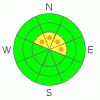
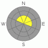
BOTTOM LINE
Danger by aspect and elevation on slopes approaching 35° or steeper.
(click HERE for tomorrow's danger rating)
|

Danger Rose Tutorial
|
While not widespread, in the wind zone at the highest elevations you’ll find pockets of Level 3 (Considerable) avalanche danger and human triggered avalanches are likely on steep, wind drifted slopes.
At treeline a Level 2 (Moderate) avalanche danger exists and human triggered avalanches are possible on steep wind drifted slopes, especially those facing the north half of the compass. While more the exception than the rule, avalanches breaking into old snow are still possible, particularly on steep upper elevation northwest, north, northeast, and east facing slopes.
A Level 1 (Low) avalanche danger will be found at lower elevations out of the wind, on southerly facing terrain, and on slopes that had no snow prior to early November storms. |
|
|
CURRENT CONDITIONS |

|
Skies are clear, winds are northwesterly at 10-20 mph, and a temperature inversion is building. Currently at 10,000 it’s in the upper 20’s, down at the trailheads temperatures are in the upper teens and low 20’s. Friday’s wind event jacked most upper elevation terrain, sculpting the snow into a moonscape texture. There are, however, a few soft patches of snow to be found in wind sheltered terrain, but with only 18”-24” of total snow depth, riding and turning options remain quite limited. |
|
|
RECENT ACTIVITY |

|
No new avalanches to report.
Click here for recent observations from around the range. |
|
|
THREAT #1 |

|
| WHERE |
PROBABILITY |
SIZE |
TREND |
|
|
|
|
| |
|
|
Over the next
24 hours.
|
|
|
Stiff, stubborn, hard wind drifts still linger along the leeward side of upper elevation ridges and around terrain features like chutes and gullies. Today's slabs feel solid under our sled, board, or skis giving us a false sense of stable snow. Problem is, they are resting on top of weak snow. With all the obstacles barely hidden under our thin snowpack, triggering even a small avalanche will ruin your day and quite possibly your season in a hurry. Avoiding steep, leeward terrain, particularly slopes with recent deposits of wind drifted snow continues to be the safe ticket item. While more the exception than the rule, there is an isolated possibility that once triggered, a small avalanche could break into weaker snow near the ground. |
|
|
THREAT #2 |

|
| WHERE |
PROBABILITY |
SIZE |
TREND |
|
|
|
|
| |
|
|
Over the next
24 hours.
|
|
|
The snowpack isn’t getting any stronger. As a matter of fact, the old October snow near the ground continues to grow weak and sugary overtime and now there’s a slab resting on top of this inherently dangerous snow structure. (Click here to see what this looks like). Avalanches triggered today can fracture wider and deeper than you might expect, breaking on weak snow near the ground. The good news is… you’d really have to go out of your way to trigger an avalanche that breaks into old snow. There's really not that much snow on the eastern front and many slopes still have anchors poking through the snow. The bad news is… if you do trigger a slide it’ll result in a nasty ride through the same anchors that are barely covered over by our thin snowpack. |
|
|
MOUNTAIN WEATHER |

|
High pressure over the region today produces warm temperatures with occasional high clouds drifting through. A weak storm system slides by the area Monday afternoon, bringing cooler temperatures, but little to no snow is expected with this front. Though details are still uncertain, colder and potentially wetter weather is possible sometime in the latter half of the upcoming week. Right now, a cold front late Wednesday looks most likely. I should have more details for Wednesday’s update. |
|
|
GENERAL ANNOUNCEMENTS |
The information in this advisory expires 24 hours after the date and time posted, but will be updated by 7:00 AM Wednesday, November 30th.
If you’re getting out and about and trigger an avalanche or see anything interesting please drop me an email at craig@utahavalanchecenter.org or call 801-231-2170
Also, now is a great time to schedule one of our free avalanche awareness presentations for your group or club. Email or call me and we’ll get you booked before things get too crazy. |
|
|
This information does not apply to developed ski areas or highways where avalanche control is normally done. This advisory is from the U.S.D.A. Forest Service, which is solely responsible for its content. This advisory describes general avalanche conditions and local variations always occur. |
|
This advisory provided by the USDA Forest Service, in partnership with:
The Friends of the Utah Avalanche Center, Utah Division of State Parks and Recreation, Utah Division of Emergency Management, Salt Lake County, Salt Lake Unified Fire Authority and the friends of the La Sal Avalanche Center. See our Sponsors Page for a complete list. |
