SPECIAL ANNOUNCEMENT |
 |
Plowing on the Mirror Lake Highway is done for the season, but maintenance on Wolf Creek Pass continues. In either case, be aware the Uinta snowpack is notoriously sketchy and much weaker than you might find in the central Wasatch.
Yesterday we were able to get our Uinta weather station network up and running and you can click here for winds, temperatures, and snow depths from around the range. Big thanks to Ted and Trent for braving the burly conditions on Windy Peak and making the necessary repairs… you guys rock! |
|
|
BOTTOM LINE
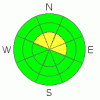
Danger by aspect and elevation on slopes approaching 35° or steeper.
(click HERE for tomorrow's danger rating)
|
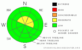
Danger Rose Tutorial
|
At and above treeline a Level 2 (Moderate) avalanche danger exists and human triggered avalanches are possible on steep wind drifted slopes, especially those facing the north half of the compass. While more the exception than the rule, avalanches breaking into old snow are still possible, particularly on steep upper elevation northwest, north, northeast, and east facing slopes.
A Level 1 (Low) avalanche danger will be found at lower elevations out of the wind, on southerly facing terrain, and on slopes that had no snow prior to early November storms. |
|
|
CURRENT CONDITIONS |

|
High, thin clouds drifted into the region overnight, keeping temperatures quite mild. Currently, it’s in the upper 20’s in the high terrain and low 30’s near the trailheads. South and southwest winds increased around 2:00 this morning and they’re blowing 30-35 mph along the high ridges. With total snow depths only averaging 18”-24” riding and turning are limited to upper elevation, rock free roads and meadows. |
|
|
RECENT ACTIVITY |

|
We spotted a shallow soft slab or two, but these are confined to the highest elevation, leeward facing slopes.
Click here for recent observations from around the range. |
|
|
THREAT #1 |

|
| WHERE |
PROBABILITY |
SIZE |
TREND |
|
|
|
|
| |
|
|
Over the next
24 hours.
|
|
|
Winds picked up over night, whipping up a fresh batch of shallow soft slabs along the leeward side of upper elevation ridgelines. Easy to detect by their rounded, pillow-like appearance, today’s slabs are manageable in size. While more the exception than the rule there is an isolated possibility that once triggered, a small avalanche could break into weaker snow near the ground. |
|
|
THREAT #2 |

|
| WHERE |
PROBABILITY |
SIZE |
TREND |

|
|
|
|
| |
|
|
Over the next
24 hours.
|
|
|
Speaking of weak snow, yesterday while stomping around in upper Weber Canyon we found the snowpack reactive to our additional weight and experienced several loud whoomphing collapses and shooting cracks. The culprit weak layer is old October snow which has grown weak and sugary overtime. The good news is… you’d really have to go out of your way to trigger an avalanche that breaks into old snow. Many slopes still have anchors poking through the snow and there’s not much of a slab resting on top of the suspect weakness. The bad news is… if you do trigger a slide it’ll result in a nasty ride through the same anchors that are barely covered over by our thin snowpack. Slamming into rocks, stumps and downed timber will definitely ruin your day, quickly resulting in a season ending injury. Click here to see what we're dealing with. |
|
|
MOUNTAIN WEATHER |

|
A ridge of high pressure is building and it’ll be a beautiful day in the mountains. One bump in the road is the south and southwest winds which will blow in the 30’s and 40’s along the high ridges. High temperatures reach into the upper 30’s at 8,000’ and near freezing at 10,000’. Overnight lows dip into the mid 20’s. A splitting system moves through the state on Thursday with very little impact other than clouds and somewhat cooler temperatures. A second system slides by on Friday producing a couple inches of snow. Warm high pressure then builds for the weekend. Other than some cooling temperatures and a flurry or two early next week, there are no big storms in sight. |
|
|
GENERAL ANNOUNCEMENTS |
The information in this advisory expires 24 hours after the date and time posted, but will be updated by 7:00 AM Thursday, November 24th with a holiday advisory.
If you’re getting out and about and trigger an avalanche or see anything interesting please drop me an email at craig@utahavalanchecenter.org or call 801-231-2170
Also, now is a great time to schedule one of our free avalanche awareness presentations for your group or club. Email or call me and we’ll get you booked before things get too crazy. |
|
|
This information does not apply to developed ski areas or highways where avalanche control is normally done. This advisory is from the U.S.D.A. Forest Service, which is solely responsible for its content. This advisory describes general avalanche conditions and local variations always occur. |
|
This advisory provided by the USDA Forest Service, in partnership with:
The Friends of the Utah Avalanche Center, Utah Division of State Parks and Recreation, Utah Division of Emergency Management, Salt Lake County, Salt Lake Unified Fire Authority and the friends of the La Sal Avalanche Center. See our Sponsors Page for a complete list. |
