SPECIAL ANNOUNCEMENT |
 |
Mirror Lake Highway is currently open, but plowing is limited. The Uinta snowpack is notoriously sketchy and much weaker than you might find in the central Wasatch.
Cinepointe 6 in Ogden is donating a night at their theater to host a benefit event for the Utah Avalanche Center. We will be showing two movies: Schooled by Deviant Sledworks and 509 Volume 6. Click here for more details.
|
|
|
BOTTOM LINE
Danger by aspect and elevation on slopes approaching 35° or steeper.
(click HERE for tomorrow's danger rating)
|
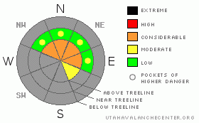
Danger Rose Tutorial
|
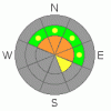
In the wind zone a Level 3 (Considerable) avalanche danger exists on steep, upper elevation slopes facing the north half of the compass. Human triggered avalanches are probable, particularly on slopes with recent deposits of wind drifted snow and those that had pre-existing October snow prior to last weekends storm.
A Level 1 (Low) avalanche danger will be found out of the wind, on southerly facing terrain, and on slopes that had no snow prior to this weekend’s storm. |
|
|
CURRENT CONDITIONS |

|
Skies cleared overnight allowing temperatures to bottom out in the low teens. West and northwest winds are averaging 15-25 mph at the upper elevations, gusting into the 30’s and 40’s along the highest ridges. No new snow has fallen since the big weekend storm and total snow depths average about 2’ at the upper elevations. Riding and turning options are quite limited, but there is enough upper elevation snow to take the sled for a road ride or crank out a few turns on low angle, rock free slopes. |
|
|
RECENT ACTIVITY |

|
Upper elevation terrain in the wind zone experienced a natural avalanche cycle over the weekend with slides averaging a couple feet deep and running on weak, sugary October snow near the ground.
Click here for recent observations from around the region. |
|
|
THREAT #1 |

|
| WHERE |
PROBABILITY |
SIZE |
TREND |
|
|
|
|
| |
|
|
Over the next
24 hours.
|
|
|
While the snowpack adjusts to the big weekend storm, reports of widespread collapsing and booming “whoomphs” continue to stream in. Of course this is a huge sign that all is not well with our snowpack and the basic structure of the pack- strong snow on top of weak snow- is inherently dangerous. I suspect conditions won’t be as tender as they were over the weekend and that may lure you into steeper terrain or well out onto the slope before it fails. Avalanches triggered today will break wider than you might expect, especially on steep, upper elevation, wind loaded slopes. Triggering a slide today can result in a nasty, season ending ride as you slam through rocks and stumps barely covered by our thin snowpack. Best way to play it safe is to head to lower elevation terrain that was void of snow prior to this weekend’s big storm. |
|
|
MOUNTAIN WEATHER |

|
Weak high pressure is building and we should see mostly sunny skies and warming temperatures. Highs today reach into the low to mid 30’s with overnight lows dipping into the teens. Northwesterly winds will be a nuisance, gusting into the 40’s and 50’s at the upper elevations. Winds switch around to the southwest and ramp up significantly Thursday night and especially Friday as the next system approaches the region. This too looks like a good snow producer and we should see a couple feet of snow by Sunday morning. |
|
|
GENERAL ANNOUNCEMENTS |
The information in this advisory expires 24 hours after the date and time posted, but will be updated by 7:00 AM Saturday, November 19th.
If you’re getting out and about and trigger an avalanche or see anything interesting please drop me an email at craig@utahavalanchecenter.org or call 801-231-2170
Also, now is a great time to schedule one of our free avalanche awareness presentations for your group or club. Email or call me and we’ll get you booked before things get too crazy. |
|
|
This information does not apply to developed ski areas or highways where avalanche control is normally done. This advisory is from the U.S.D.A. Forest Service, which is solely responsible for its content. This advisory describes general avalanche conditions and local variations always occur. |
|
This advisory provided by the USDA Forest Service, in partnership with:
The Friends of the Utah Avalanche Center, Utah Division of State Parks and Recreation, Utah Division of Emergency Management, Salt Lake County, Salt Lake Unified Fire Authority and the friends of the La Sal Avalanche Center. See our Sponsors Page for a complete list. |
