SPECIAL ANNOUNCEMENT |
 |
Mirror Lake Highway is currently open, but limited plowing could mean the road is a complete mess. Whatever the case, don't let this easy access to the western Uintas lull you into a false sense of security just because you can see your car from a nearby ridge or mountain top. The Uinta snowpack is notoriously sketchy and much weaker than you might find in the central Wasatch. If you're getting into steep terrain, be prepared for your own self rescue- that means wear and know how to use an avalanche beacon, shovel and probe. Above all… think about the consequences of triggering an avalanche. |
|
|
BOTTOM LINE
Danger by aspect and elevation on slopes approaching 35° or steeper.
(click HERE for tomorrow's danger rating)
|
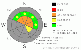
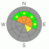
Danger Rose Tutorial
|
In the wind zone a Level 3 (Considerable) avalanche danger exists on steep, upper elevation slopes facing the north half of the compass. Human triggered avalanches are probable, particularly on slopes with recent deposits of wind drifted snow.
A Level 1 (Low) avalanche danger will be found out of the wind, on southerly facing terrain, and on slopes that had no snow prior to this weekend’s storm. |
|
|
CURRENT CONDITIONS |

|
Yesterday’s storm system was good to the eastern front, laying down about a foot of medium density new snow at the upper elevations. In addition to the new snow, winds have been the big headline story. On Saturday they gusted into the 60’s and 70’s before becoming more reasonable early this morning, backing off into the 30’s and 40’s. Currently, light snow is falling and temperatures are in the mid to upper 20’s.
The mountains are white from far… but far from white. Riding and turning conditions are thin and limited to all but the highest north facing slopes. Grassy meadows and rock free roads are your best bet for early season turns or for a quick spin on the new sled. Click here to check out Ted's great observation from the Whitney area on Wednesday. |
|
|
RECENT ACTIVITY |

|
No new avalanches to report.
Click here for recent observations from around the region. |
|
|
THREAT #1 |

|
| WHERE |
PROBABILITY |
SIZE |
TREND |
|
|
|
|
| |
|
|
Over the next
24 hours.
|
|
|
Wind is the great equalizer in the western Uintas and this storm system didn’t disappoint. South, southwest, and now westerly winds have been cranking for the past 24 hours, forming stiff, dense slabs which will be sensitive to the additional weight of a rider today. The good news is, the danger is easy to predict and limited to upper elevation, northerly facing slopes which have pre-existing snow left over from the early October storms. The bad news is, there’s weak snow on top of some slick melt-freeze crusts and even a small avalanche is going to pack a healthy punch. Avalanches triggered today will break wider than you might expect, especially on steep, upper elevation, wind loaded slopes. Triggering a slide today can result in a nasty, season ending ride as you slam through rocks and stumps barely covered by our thin snowpack. Best way to play it safe is to head to lower elevation terrain that were void of snow prior to this weekend’s big storm. |
|
|
MOUNTAIN WEATHER |

|
Another good shot of snow is materializing this morning with an additional 4”-8” expected. Westerly winds will continue to blow 30-40 mph with gusts in the 50’s and 60’s along the high ridges. High temperatures will be in the mid 20’s with overnight lows in the mid teens. A cool and moist Northwest flow prevails across the mountains into mid week. The next chance of light snow fall will be with a cold front Monday night and Tuesday. |
|
|
GENERAL ANNOUNCEMENTS |
The information in this advisory expires 24 hours after the date and time posted, but will be updated by 7:00 AM Wednesday, November 16th.
If you’re getting out and about and trigger an avalanche or see anything interesting please drop me an email at craig@utahavalanchecenter.org or call 801-231-2170
Also, now is a great time to schedule one of our free avalanche awareness presentations for your group or club. Email or call me and we’ll get you booked before things get too crazy. |
|
|
This information does not apply to developed ski areas or highways where avalanche control is normally done. This advisory is from the U.S.D.A. Forest Service, which is solely responsible for its content. This advisory describes general avalanche conditions and local variations always occur. |
|
This advisory provided by the USDA Forest Service, in partnership with:
The Friends of the Utah Avalanche Center, Utah Division of State Parks and Recreation, Utah Division of Emergency Management, Salt Lake County, Salt Lake Unified Fire Authority and the friends of the La Sal Avalanche Center. See our Sponsors Page for a complete list. |
