SPECIAL ANNOUNCEMENT |
 |
April showers… bring spring powder! With a big storm on tap, we’ll open the avalanche center doors and continue issuing advisories through the weekend. |
|
|
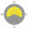
BOTTOM LINE
Danger by aspect and elevation on slopes approaching 35° or steeper.
(click HERE for tomorrow's danger rating)
|

Danger Rose Tutorial
|
At and above treeline the avalanche danger is a Level 2 (MODERATE) and human triggered avalanches are possible on steep wind drifted slopes. As you gain elevation the avalanche danger increases. In the wind zone, along the leeward side of high elevation ridges, pockets of Level 3 (CONSIDERABLE) danger exist and human triggered avalanches are probable.
In upper elevation, steep, rocky terrain facing the north half of the compass, pockets of Level 3 (CONSIDERABLE) danger exist. Avalanches breaking to the January raincrust will be deep and dangerous.
The danger for wet avalanches on steep, mid and low elevation sun exposed slopes will increase from Level 1 (LOW) this morning to Level 2 (MODERATE) with daytime heating. Human triggered avalanches will be possible, especially during the heat of the day. With heating, cornices may become more tender, so be sure to steer clear of these huge overhanging boxcars. |
|
|
CURRENT CONDITIONS |

|
Man, what a great shot of snow for the eastern front. The cold Pacific storm that’s been homesteading over the region the past few days is pulling up its tent stakes and moving east…. it will be missed. Storm totals are well over 2’ and in most upper elevation terrain, especially around the North Slope, hovering right around 30”. West and southwest winds have been blowing in the 20’s and 30’s all night, though in the past couple hours bumped up into the 30’s and 40’s along the high ridges. Skies are mostly cloudy and temperatures are in the low to mid teens. Riding conditions are epically deep! |
|
|
RECENT ACTIVITY |

|
Shallow soft slabs within the new storm snow have been reported on steep wind drifted slopes. Click here for a great observation Ted captured near Gold Hill on Friday.
Click here for recent observations from around the range. |
|
|
THREAT #1 |

|
| WHERE |
PROBABILITY |
SIZE |
TREND |

|
|
|
|
| |
|
|
Over the next
24 hours.
|
|
|
Yesterday’s new snow was pretty tender along the ridges and shallow soft slabs were easy to initiate and got running farther than you might expect. However, it never ceases to amaze me how just a little bit of strong springtime sun filtering through high clouds can rapidly stabilize new snow instabilities. With a bump in winds overnight and plenty of light density snow available to whip into fresh drifts, I’d expect today’s wind slabs will be quite sensitive to the weight of a rider. While most of today’s wind drifts are manageable in size, carefully evaluate each slope on an individual basis, especially when you’re getting into steep wind drifted terrain or riding from one drainage to another. Along the leeward side of upper elevation ridges, avalanches triggered within the new snow can break wider and deeper than you might expect and will pack a punch once they get moving. Slope cuts on small test slopes and road cuts are a great way to gather information and see what kind of avalanche dragon you’re dealing with. |
|
|
THREAT #2 |

|
| WHERE |
PROBABILITY |
SIZE |
TREND |
|
|
|
|
| |
|
|
Over the next
24 hours.
|
|
|
We’ve added just over two inches of water to our snowpack in the past few days and each time significant storms have rolled through the region we’ve seen avalanches break below the January raincrust. Today and tomorrow the snowpack will get a taste of strong springtime sun and all the light powder will start consolidating and become strong and cohesive. We might not feel that much of a change when we’re riding, but the snowpack will definitely know. As the pack begins to transition towards stronger snow it may reactivate some of the weak layers now buried deeply in our snowpack. If we’re in the right place at the wrong time the avalanche we trigger will be deep and dangerous, breaking below the January raincrust. While isolated to steep, rocky, upper elevation terrain facing the north half of the compass, if you're getting into terrain that has these characteristics, carefully analyze the slope, your escape routes, and think of the consequences of triggering a slide. |
|
|
THREAT #3 |

|
| WHERE |
PROBABILITY |
SIZE |
TREND |

|
|
|
|
| |
|
|
Over the next
24 hours.
|
|
|
At lower elevations, warmer temperatures and brief glimpses of strong spring sunshine rapidly change the new snow into damp, manky, mashed potatoes. If the sun comes out for any length of time or if we experience a rapid warm up, the avalanche danger will increase accordingly. When you’re seeing roller balls cascading down the slope it means the snow is starting to heat up and it’s time to move to a cooler aspect. In addition, you may be able to trigger small wet avalanches when side-hilling on steep, lower elevation slopes. You’ll definitely want to avoid terrain traps like gullies and creek bottoms where the heavy, wet, bone snapping debris will pile up deeply. |
|
|
MOUNTAIN WEATHER |

|
A moist and unstable northwest flow keeps a few snow showers lingering throughout the morning hours. Westerly winds will gust into the 40’s and 50’s along the high ridges before backing off later today. High temperatures reach into the mid 20’s, dipping into the teens overnight. Partly cloudy skies and a warming trend develop for Monday. Snow is likely again Tuesday as a weak cold front crosses northern Utah. Another system brings more snow Wednesday into Thursday. |
|
|
GENERAL ANNOUNCEMENTS |
The information in this advisory expires 24 hours after the date and time posted, but will be updated by 7:00 AM Saturday, Apr.16th, 2011.
If you’re getting out and about and trigger an avalanche or see anything interesting please let us know here. Or drop Craig an email : craig@utahavalanchecenter.org or call 801-231-2170
The western Uinta advisory program is going full tilt and forecasts will be issued by 7:00 AM on Wednesday, Saturday, Sunday and all holidays. |
|
|
This information does not apply to developed ski areas or highways where avalanche control is normally done. This advisory is from the U.S.D.A. Forest Service, which is solely responsible for its content. This advisory describes general avalanche conditions and local variations always occur. |
|
This advisory provided by the USDA Forest Service, in partnership with:
The Friends of the Utah Avalanche Center, Utah Division of State Parks and Recreation, Utah Division of Emergency Management, Salt Lake County, Salt Lake Unified Fire Authority and the friends of the La Sal Avalanche Center. See our Sponsors Page for a complete list. |
