SPECIAL ANNOUNCEMENT |
 |
Sunday April 3rd will be the last of our regularly scheduled advisories for the season. |
|
|
BOTTOM LINE
Danger by aspect and elevation on slopes approaching 35° or steeper.
(click HERE for tomorrow's danger rating)
|
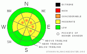
Danger Rose Tutorial
|
At and above treeline fresh wind drifts will be sensitive to the weight of a rider and a Level 2 (MODERATE) avalanche danger exists. If you’re traveling along the high ridges in the wind zone, you’ll find pockets of Level 3 (CONSIDERABLE) avalanche danger. Human triggered avalanches are probable on steep wind drifted slopes in terrain facing the north half of the compass. Also, be sure to give the monster cornices a wide berth.
Our deep slab issue hasn't gone away and in general a Level 2 (MODERATE) avalanche danger associated with this persistent problem child exists. While not widespread, the danger is most pronounced on steep, rocky, upper elevation slopes where you can still trigger an avalanche that breaks to the January raincrust. While the chances of triggering a deep slab avalanche are isolated, the consequences are very severe.
A Level 1 (LOW) avalanche danger exists out of the wind and on low elevation, low angle slopes. |
|
|
CURRENT CONDITIONS |

|
A blanket of clouds moved over the region late yesterday as the trailing end of a weak system brushes by northern Utah. Temperatures are mild, in the low to mid 20’s. West-southwest picked up late yesterday and have been blowing all night in the 20-30 mph range. In the last hour or two they bumped up and are gusting to 40 mph. Yesterday’s strong sunshine crusted many sunny slopes, especially at lower elevations, but excellent riding and turning conditions will still be found on sheltered, shady, mid and upper elevation slopes. |
|
|
RECENT ACTIVITY |

|
Monday’s quick hitting storm produced pockety avalanches on steep, leeward facing slopes at upper elevations. Averaging a foot deep and running within the new storm snow, most were manageable in size.
Click here for recent observations from around the range. |
|
|
THREAT #1 |

|
| WHERE |
PROBABILITY |
SIZE |
TREND |
|
|
|
|
| |
|
|
Over the next
24 hours.
|
|
|
Yesterday, Ted and I stomped around the Super Bowl and found the warm spring-like temperatures rapidly stabilizing Monday’s storm snow. However, winds picked up late in the day and a whole new batch of wind slabs were rapidly forming. Mostly confined to upper elevation, leeward terrain, today’s drifts are easy to detect by their pillow-like rounded appearance and easy to avoid. While mostly manageable in size to begin with, once triggered, there’s a remote possibility a wind slab could break into weaker layers of snow, especially in steep, rocky terrain. Of course this series of events would create a large and unmanageable avalanche. With all the great riding to be had in wind sheltered terrain, this situation can be easily avoided and you’ll still have a blast. |
|
|
THREAT #2 |

|
| WHERE |
PROBABILITY |
SIZE |
TREND |
|
|
|
|
| |
|
|
Over the next
24 hours.
|
|
|
Coverage in the western Uinta’s is amazing right now and the pack feels solid and bomber underneath our sled or feet, allowing us to get anywhere. As a matter of fact, spring is the time of year we normally start getting into steep, radical terrain we’ve scoped out all season. It’s been over a week since our last big slide broke into snow near the January raincrust and that's good news. While recent snowpack trends and stability tests suggest most slopes are good to go, there’s still an outside chance you can trigger a deep, scary, and possibly unsurvivable slide, especially when all the right elements come together. Steep, rocky, upper elevation terrain facing the north half of the compass should still be considered suspect until otherwise proven innocent. |
|
|
THREAT #3 |

|
| WHERE |
PROBABILITY |
SIZE |
TREND |
|
|
|
|
| |
|
|
Over the next
12 hours.
|
|
|
Cornices are huge, undercut, and unpredictably breaking much further back than you might expect. In addition, you can trigger a deep, dangerous slide as the added weight of a huge block of snow trundles down the slope. You’ll definitely want to give these monsters the respect they deserve and avoid messing around or near them. |
|
|
MOUNTAIN WEATHER |

|
A moist, northwest flow brings periods of light snow and wind today through tonight. Accumulations are expected to be just a couple inches. West and northwest winds will be a nuisance, blowing 20-30 mph with gusts in the 50’s and 60’s along the high ridges. Temperatures climb into the low to mid 30’s with overnight lows dipping into the mid 20’s. High pressure aloft builds across the region for the remainder of the week, and we should see a significant warming trend. The next Pacific cold front is expected Saturday night. |
|
|
GENERAL ANNOUNCEMENTS |
The information in this advisory expires 24 hours after the date and time posted, but will be updated by 7:00 AM Saturday, Apr.2nd, 2011.
If you’re getting out and about and trigger an avalanche or see anything interesting please let us know here. Or drop Craig an email : craig@utahavalanchecenter.org or call 801-231-2170
The western Uinta advisory program is going full tilt and forecasts will be issued by 7:00 AM on Wednesday, Saturday, Sunday and all holidays. |
|
|
This information does not apply to developed ski areas or highways where avalanche control is normally done. This advisory is from the U.S.D.A. Forest Service, which is solely responsible for its content. This advisory describes general avalanche conditions and local variations always occur. |
|
This advisory provided by the USDA Forest Service, in partnership with:
The Friends of the Utah Avalanche Center, Utah Division of State Parks and Recreation, Utah Division of Emergency Management, Salt Lake County, Salt Lake Unified Fire Authority and the friends of the La Sal Avalanche Center. See our Sponsors Page for a complete list. |
