SPECIAL ANNOUNCEMENT |
 |
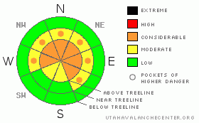
A Special Avalanche Advisory has been issued for the mountains of northern Utah including the western Uinta Mountains. Recent storms have created complex and tricky avalanche conditions. A Level 3 (CONSIDERABLE) avalanche danger exists on steep, upper elevation, wind drifted slopes, and dangerous human triggered avalanches are probable. |
|
|
BOTTOM LINE
Danger by aspect and elevation on slopes approaching 35° or steeper.
(click HERE for tomorrow's danger rating)
|

Danger Rose Tutorial
|
At and above treeline fresh wind drifts will be sensitive to the weight of a rider. You’ll find a Level 3 (CONSIDERABLE) avalanche danger on steep wind drifted slopes, especially along the high ridges and human triggered avalanches are probable in terrain facing the north half of the compass. Also, be sure to give the monster cornices a wide berth.
Our deep slab issue hasn't gone away and in general a Level 2 (MODERATE) avalanche danger associated with this persistent problem child exists. While not widespread, pockets of Level 3 (CONSIDERABLE) avalanche danger exist, especially in steep, rocky terrain, where you can still trigger an avalanche that breaks to the January raincrust. While the chances of triggering a deep slab avalanche are isolated, the consequences are very severe.
A Level 1 (LOW) avalanche danger exists out of the wind, on low elevation, low angle slopes. |
|
|
CURRENT CONDITIONS |

|
Yet another in a series of storms is right on our doorstep this morning. Skies are mostly cloudy, west and southwest winds are blowing 20-40 mph along the high ridges, and temperatures are in the upper teens and low 20’s. Yesterday’s quick hitting storm delivered 6” of new snow across the range, providing excellent riding and turning conditions. |
|
|
RECENT ACTIVITY |

|
Saturday's large avalanche on Horseshoe Mountain in San Pete County resulted in the tragic loss of a young mans life. Our prayers and thoughts go out to the friends and family of Garrett Smith. You can click here for snowpack details surrounding the accident.
No new avalanche activity to report from yesterday. Click here for recent observations. |
|
|
THREAT #1 |

|
| WHERE |
PROBABILITY |
SIZE |
TREND |

|
|
|
|
| |
|
|
Over the next
24 hours.
|
|
|
Winds have once again been a big player on the eastern front and there's plenty of snow available for transport as a result of the recent parade of storms. This morning you’ll find a whole new batch of fresh wind drifts along the leeward side of upper elevation ridges and around terrain features like chutes and gullies. The fresh drifts will predictably break at or below our sled, skis, or board, but with more snow and wind on tap, I expect the drifts to become more widespread and more reactive to the weight of a rider as the day wares on. There’s plenty of new snow for the wind to whip into sensitive slabs, so be sure to re-evaluate your terrain choices, particularly during periods of heavy snowfall. |
|
|
THREAT #2 |

|
| WHERE |
PROBABILITY |
SIZE |
TREND |

|
|
|
|
| |
|
|
Over the next
24 hours.
|
|
|
Each time the wind blows or we receive a substantial amount of snow or water, the range experiences at least one large natural slide that breaks below the January rain crust. After last week’s raging winds a huge avalanche on the hanging snowfield just below Haystack Peak broke very deeply, creating a large and destructive slide. Of course no one would be riding in this type of terrain, but with the solid, “go anywhere” snowpack we have right now, we can get into steep, rocky terrain that has similar snowpack characteristics. While the chances of triggering an avalanche that breaks deep and wide are isolated, the consequences will be devastating and quite possibly unsurvivable. Remember- when in doubt of the snowpack tone your slope angles down and match the terrain with the consequences of triggering a slide. |
|
|
THREAT #3 |

|
| WHERE |
PROBABILITY |
SIZE |
TREND |

|
|
|
|
| |
|
|
Over the next
12 hours.
|
|
|
Cornices are huge, undercut, and unpredictably breaking much further back than you might expect. In addition, you can trigger a deep, dangerous slide as the added weight of a huge block of snow trundles down the slope. You’ll definitely want to give these monsters the respect they deserve and avoid messing around or near them. |
|
|
MOUNTAIN WEATHER |

|
It looks like our next storm system is just crossing the lake and should be reaching the western Uinta’s in the next couple of hours. Today we can anticipate a period of heavy snow with 8”-10” stacking up by late afternoon. In addition, westerly winds in the 20-40 mph range with gusts near 50 mph along the ridges are expected. High temperatures hover in the mid 20’s, before crashing into the low teens overnight under clearing skies. A weak system is on tap for late Tuesday and then high pressure builds for the latter half of the week. |
|
|
GENERAL ANNOUNCEMENTS |
The information in this advisory expires 24 hours after the date and time posted, but will be updated by 7:00 AM Wednesday, Mar. 30th, 2011.
If you’re getting out and about and trigger an avalanche or see anything interesting please let us know here. Or drop Craig an email : craig@utahavalanchecenter.org or call 801-231-2170
The western Uinta advisory program is going full tilt and forecasts will be issued by 7:00 AM on Wednesday, Saturday, Sunday and all holidays. |
|
|
This information does not apply to developed ski areas or highways where avalanche control is normally done. This advisory is from the U.S.D.A. Forest Service, which is solely responsible for its content. This advisory describes general avalanche conditions and local variations always occur. |
|
This advisory provided by the USDA Forest Service, in partnership with:
The Friends of the Utah Avalanche Center, Utah Division of State Parks and Recreation, Utah Division of Emergency Management, Salt Lake County, Salt Lake Unified Fire Authority and the friends of the La Sal Avalanche Center. See our Sponsors Page for a complete list. |

