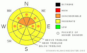
BOTTOM LINE
Danger by aspect and elevation on slopes approaching 35° or steeper.
(click HERE for tomorrow's danger rating)
|
Danger Rose Tutorial
|
Big winds & light snow have made for fresh windslabs sensitive to the weight of a rider, making for a Level 3 (Considerable) avalanche hazard on mid & high elevation slopes facing W, NW, N, NE & E.
A Level 2 (Moderate) avalanche hazard exists on mid & upper elevation slopes facing W, NW, N, NE & E due to the threat of a deep slab avalanche. While the chances of triggering it are low, if you do, you're looking at a large, destructive & potentially un-survivable avalanche.
A warm night in the mountains left slopes below 9000' without a refreeze. So long as the clouds shield us from the sun, a Level 2 (Moderate) avalanche hazard exists due to wet avalanche danger at mid & low elevations, be especially heads up in terrain traps like gulleys & creek bottoms. |
|
|
CURRENT CONDITIONS |

|
Excellent turning & riding conditions can be found in wind protected areas. Staying out of the wind is key as it's currently hammering the high peaks at a sustained 45 mph, gusting to 60 mph out of the S-SE. Equally interesting are this morning’s temperatures. Anything below 9000' didn't freeze last night. |
|
|
RECENT ACTIVITY |

|
Ted & I found a few wind slab avalanches on northerly facing slopes formed by the combination of big SW winds & a foot of light density snow delivered on Thursday morning. Click here for details. |
|
|
THREAT #1 |

|
| WHERE |
PROBABILITY |
SIZE |
TREND |
|
|
|
|
| |
|
|
Over the next
24 hours.
|
|
|
There's plenty of snow available for the creation of wind slabs thanks to the foot we received early Thursday. Winds are currently cranking out of the south and are expected to stay that way for the duration of the day. Fresh wind slabs sensitive to the weight of a rider will be most prominent up in the wind zone at and above treeline. Snow that suddenly feels stiff under your machine, shooting cracks, fat pillow like formations; these things are all indicative of wind slab & instability. If you're seeing these things then you're probably in the wrong place. Head to somewhere protected from the wind for the best riding & turning today. |
|
|
THREAT #2 |

|
| WHERE |
PROBABILITY |
SIZE |
TREND |
|
|
|
|
| |
|
|
Over the next
6 hours.
|
|
|
It was a very warm night in the mountains. The snowpack relies on temperatures below 32° for strength, and last night temps stayed above freezing below 9000'. Today we're looking at mostly cloudy skies & a return to cold temps this afternoon, so, I don't expect things to come unglued. But, you will find a lot of wet snow at low & mid elevations this morning. This could pose a hazard in terrain traps like gulleys and creek bottoms where wet avalanches are possible, and once moving will entrain enough snow to cause harm. |
|
|
THREAT #3 |

|
| WHERE |
PROBABILITY |
SIZE |
TREND |
|
|
|
|
| |
|
|
Over the next
24 hours.
|
|
|
Ted I spent all of yesterday gathering information on the buried surface hoar, now 55" below the snow surface. We dug in a number of different locations, conducted a wide variety of tests, and were unable to get the surface hoar to react. We concluded that this layer is unreactive for the time being. But events like this one in our neighbors to the west remind us that you can never take your eye off of surface hoar.
We're now into the classic high consequence, low probability scenario that keeps forecasters up at night. While the chances of triggering an avalanche failing in the surface hoar are currently low, if you do it will likely be a large destructive & potentially un-survivable event.
When the stability is in question, the answer can always be found in terrain. Sticking to the lower angle more protected mid elevation slopes will minimize your exposure to this hazard. Those poking around in the big bowls should remember that the potential to pull out the big one still exists. |
|
|
MOUNTAIN WEATHER |

|
Cloudy skies and gusty winds are expected this morning as a fast moving cold front approaches the region. We will start to see some light precipitation around lunch time, but where it goes from there is anybody's guess. Light snow showers are likely to persist, but with the right timing of a few different events, we could see snow totals jump towards 6". But don't count on it, storm totals of an inch are equally likely. Storms look to be lined up nicely for the coming week, we should pick up a few inches here and there through the middle of the work week. Looks like we may be in store for a significant system late next week, but forecasting weather that far out is more fiction that fact. |
|
|
GENERAL ANNOUNCEMENTS |
The information in this advisory expires 24 hours after the date and time posted, but will be updated by 7:00 AM Sunday, Mar. 20th, 2011.
If you’re getting out and about and trigger an avalanche or see anything interesting please let us know here. Or drop Craig an email : craig@utahavalanchecenter.org or call 801-231-2170
The western Uinta advisory program is going full tilt and forecasts will be issued by 7:00 AM on Wednesday, Saturday, Sunday and all holidays. |
|
|
This information does not apply to developed ski areas or highways where avalanche control is normally done. This advisory is from the U.S.D.A. Forest Service, which is solely responsible for its content. This advisory describes general avalanche conditions and local variations always occur. |
|
This advisory provided by the USDA Forest Service, in partnership with:
The Friends of the Utah Avalanche Center, Utah Division of State Parks and Recreation, Utah Division of Emergency Management, Salt Lake County, Salt Lake Unified Fire Authority and the friends of the La Sal Avalanche Center. See our Sponsors Page for a complete list. |
