Uintas Avalanche Advisory

Forecaster: Craig Gordon

BOTTOM LINE

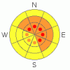
Danger by aspect and elevation on slopes approaching 35° or steeper.
(click HERE for tomorrow's danger rating)


Danger Rose Tutorial

At upper elevations especially in steep wind drifted terrain at and above treeline a Level 3 (CONSIDERABLE) avalanche danger exists and human triggered avalanches are likely. Be aware that within this elevation band you’ll encounter pockets of Level 4 (HIGH) avalanche danger particularly along the high ridges in the wind zone.

The less predictable avalanche dragon is the slabs which can break deeply into the buried surface hoar layer, producing a large and very dangerous avalanche. A Level 3 (CONSIDERABLE) avalanche danger exists at mid and upper elevations, particularly on slopes facing West, Northwest, North, Northeast, and East. Human triggered avalanches are likely in this type of terrain.

At mid elevations that received less wind and snow, a Level 2 (MODERATE) avalanche danger exists and human triggered avalanches are possible on steep leeward slopes.

Out of the wind in mid and low elevation terrain a Level 1 (LOW) avalanche danger exists.


CURRENT CONDITIONS

Last night’s storm system rolled through the region with a vengeance, depositing about a foot of new snow throughout the range. South, southeast, and southwest winds cranked all day and into the evening, blowing in the 40’s and 50’s, gusting into the 70’s near high peaks. They’ve mellowed out somewhat, switched to the west and northwest and are currently blowing 20-30 mph. Temperatures are in the low to mid teens, with single digits reported along the high ridges.


RECENT ACTIVITY

No observations from yesterday, but we heard about a Size 2 natural on a steep NE facing slope in upper Chalk Creek on Monday. Likely the result of yesterdays sustained southerly winds and warm temps.


THREAT #1

WHERE PROBABILITY SIZE TREND
      Over the next 24 hours.

Strong winds blew the dense snow into cohesive slabs that will be reactive to the weight of a rider today. You’ll find the majority of these fresh drifts on the leeward side of mid and upper elevation ridgelines on slopes facing the north half of the compass. In addition, due to the strength of the wind, drifts formed a little further downslope than we normally expect to see. Easy to detect by their rounded, humpback whale-like appearance, today you’ll want to avoid any steep, upper elevation, wind drifted slope. Avalanches triggered within the new storm snow can break into weaker layers, now buried deep in the snowpack, resulting in a large, unmanageable, and dangerous slide. Out of wind affected terrain not only will you decrease your odds of triggering a slide you’ll find deep, spongy powder. … sounds like a good tradeoff to me!


THREAT #2

WHERE PROBABILITY SIZE TREND
      Over the next 48 hours.

Now here's where conditions become less predictable-

We've been talking at length about the now buried January surface hoar, which sits under the infamous MLK rain crust. It's a strange combination, one that we're not used to dealing with. The fact of the matter is that it's surprising very experienced riders. Why?

Well, part of it is that the snow feels so good under our machines. It's stiff and supportable and now has a fresh powder topping. Sounds like great riding conditions, but that doesn't tell the whole story. Remember- we’ve got to not only think about the snow we’re riding in, but also the snow we’re riding on. That supportable snow is actually a stiff and very well connected three foot deep (and growing) slab. Unfortunately, the patent is still pending on our “Avalanche Detection Goggles” and there are weak points in the slab that we just can't see unless we dig into the snow and investigate the layering. Problem is, as soon as we ride over one of those weak points, the slab pulls out and we're off on a ride that may very well be unsurvivable.

It's misleading because you can ride a number of slopes without incident and then Wham, the next one avalanches. That's the challenging characteristic of what we’re dealing with right now and the terrain doesn’t need to be big and gnarly either. As a matter of fact, a number of recent avalanches have been triggered on very low angle slopes. One recurring theme with the human triggered avalanches has been mid slope breakovers, just a few degrees steeper than the rest of the slope. We don’t feel it, but the avalanche is all over it.

Every significant storm has sparked a natural avalanche cycle with the surface hoar as the guilty layer. The last round of avalanches averaged 3' in depth. We just added another foot of snow with nuking winds, which should be more than enough weight to initiate a natural avalanche cycle, but this time the depths will be pushing 5'…. Yikes!

So, what can we do as riders to have fun, but still get home in one piece at the end of the day? When our buddies are riding, we can stay well out of the avalanche runouts, watching our partners safely from a distance. Be aware of what's above you, as the current situation promotes remote triggering, meaning you can trigger avalanches far above you from great distances. Be heads up! We can use the terrain to our advantage too, but right now we've got to tone down our terrain choices. We can safely ride very low angle slopes at mid and lower elevations. We can work ridgelines to get up high, but we've got to be careful not to get sucked into the open faces where the avalanche danger is deceptively elevated. I know this kind of riding isn't nearly as thrilling as ripping up steep tree shots and open bowls, but right now, the more aggressive riding is a pure roll of the dice, and there's a reason that the house wins more often than not.


MOUNTAIN WEATHER

Snow showers rapidly end this morning and we should see partly cloudy skies with temperatures warming into the mid and upper 20’s. Winds become light and northwesterly, blowing less than 25 mph along the ridges. Under clear skies, overnight lows dip into the single digits. After a break tomorrow and tomorrow night, several weak disturbances may bring light snow to the region this upcoming weekend.


GENERAL ANNOUNCEMENTS

The information in this advisory expires 24 hours after the date and time posted, but will be updated by 7:00 AM Saturday, Mar. 19th, 2011.

If you’re getting out and about and trigger an avalanche or see anything interesting please let us know here. Or drop Craig an email : craig@utahavalanchecenter.org or call 801-231-2170

The western Uinta advisory program is going full tilt and forecasts will be issued by 7:00 AM on Wednesday, Saturday, Sunday and all holidays.


This information does not apply to developed ski areas or highways where avalanche control is normally done.  This advisory is from the U.S.D.A. Forest Service, which is solely responsible for its content. This advisory describes general avalanche conditions and local variations always occur.


This advisory provided by the USDA Forest Service, in partnership with:

The Friends of the Utah Avalanche Center, Utah Division of State Parks and Recreation, Utah Division of Emergency Management, Salt Lake County, Salt Lake Unified Fire Authority and the friends of the La Sal Avalanche Center. See our Sponsors Page for a complete list.