Uintas Avalanche Advisory

Forecaster: Grant Helgeson

BOTTOM LINE

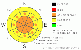
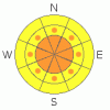
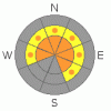
Danger by aspect and elevation on slopes approaching 35° or steeper.
(click HERE for tomorrow's danger rating)


Danger Rose Tutorial

The most serious issue is the deep slab. Today, the deep slab hazard is (Level 2) Moderate. Tomorrow fresh snow will push the deep slab hazard up to (Level 3) Considerable. There may even be an hour or two early Thursday morning where the overall hazard is (Level 4) High.

Watch for wind slabs on the north half of the compass today as winds continue to blast out of the south. On Thursday, watch for fresh sensitive wind slabs on slopes that face the south half of the compass as northerly winds fueled by new snow create wind slabs both at upper & mid elevations making for a Level 3 (Considerable) wind slab avalanche hazard.


CURRENT CONDITIONS

Big southerly winds are raging across the high peaks keeping temperatures warm and clocking in at 40 mph, gusting to 60 mph.

The old snow surface is getting a bit tired. There's a thin melt freeze crust on nearly all aspects and elevations from the recent warm temperatures and strong Spring sun. Needless to say, we're in need of a refresh, and that's just what we're expecting this evening in the form of a robust cold front currently streaming into the region.


RECENT ACTIVITY

We heard about a Size 2 natural on a steep NE facing slope in upper Chalk Creek yesterday. Likely the result of yesterdays sustained southerly winds and warm temps.


THREAT #1

WHERE PROBABILITY SIZE TREND
      Over the next 24 hours.

There are two components of wind slab hazard to deal with over the next 48 hours.

The first can be found today on slopes facing the north half of the compass. Southerly Winds are at the threshold speed to pick up snow and move it around, creating wind slabs on slopes that face NW, N & NE. The wind will continue to build these slabs throughout the day Wednesday.

The second component comes into play this evening with the arrival of the cold front. It should begin to snow in earnest around dinner time, and winds will shift to the north. This evening’s winds will have new snow to work with, so, be heads up for fresh sensitive wind slabs on slopes facing the south half of the compass on Thursday. These will exist not only up high, but down into the trees as well.


THREAT #2

WHERE PROBABILITY SIZE TREND
      Over the next 48 hours.

Here's where things get weird.

We've been talking at length about the now buried January surface hoar, which sits under the infamous MLK rain crust. It's a strange combination, one that we're not used to dealing with. The fact of the matter is that it's surprising very experienced riders. Why?

Well, part of it is that the snow feels so good under our machines. It's stiff & supportable with a bit of creamy topping. Sounds like great sledding conditions, but, that doesn't tell the whole story. That supportable snow is actually a stiff & very well connected three foot deep (& growing) slab. There are weak points in the slab that we just can't see, and as soon as we ride over one of those weak points, the slab pulls out and we're off on a ride that may very well be unsurvivable.

It's misleading because you can ride a number of slopes without incident and then Wham, the next one avalanches. That's the nature of the current hazard. The slopes don't need to be big & knarly either, a number of the recent avalanches have been triggered on very low angle slopes. One recurring theme with the human triggered avalanches has been mid slope break overs/ roll overs/ convex rollers. Basically, places where the terrain rolls away.

Every significant storm has sparked a natural avalanche cycle with the surface hoar as the guilty layer. The last round of avalanches averaged 3' in depth. We're about to add another 1.5' to it, which should be more than enough snow to start a natural avalanche cycle, but this time the depths will be pushing 5'. Yikes.

So, what can we do as riders to have fun, but still get home in one piece at the end of the day? When our buddies are riding, we can stay well out of the avalanche runouts, watching our partners safely from a distance. Be aware of what's above you, as the current situation promotes remote triggering, meaning you can trigger avalanches far above you from great distances. Be heads up! We can use the terrain to our advantage too. Right now, we've got to tone down our terrain selection. We can safely ride very low angle slopes at mid & lower elevations. We can work ridgelines to get up high, but we've got to be careful that we don't get sucked into the open faces where the avalanche hazard is considerable. This kind of riding isn't nearly as thrilling as ripping up steep tree shots and open bowls, but right now, the more aggressive riding is a pure roll of the dice, and there's a reason that the house wins more often than not.


MOUNTAIN WEATHER

Pre-frontal winds are currently raging across the high peaks coming out of the south. These warm winds will keep today's temperatures very mild, hovering just below the freezing point. This will continue until around supper time when the winds shift to the north and it begins snowing, heavy at times. Temps will cool down to the lower twenties overnight as snowfall continues into Thursday morning. We get a break Friday to (safely) feast on fresh powder, and then we move back into the storm cycle for the weekend. Check back Saturday for more details.


GENERAL ANNOUNCEMENTS

The information in this advisory expires 24 hours after the date and time posted, but will be updated by 7:00 AM Saturday, Mar. 19th, 2011.

If you’re getting out and about and trigger an avalanche or see anything interesting please let us know here. Or drop Craig an email : craig@utahavalanchecenter.org or call 801-231-2170

The western Uinta advisory program is going full tilt and forecasts will be issued by 7:00 AM on Wednesday, Saturday, Sunday and all holidays.


This information does not apply to developed ski areas or highways where avalanche control is normally done.  This advisory is from the U.S.D.A. Forest Service, which is solely responsible for its content. This advisory describes general avalanche conditions and local variations always occur.


This advisory provided by the USDA Forest Service, in partnership with:

The Friends of the Utah Avalanche Center, Utah Division of State Parks and Recreation, Utah Division of Emergency Management, Salt Lake County, Salt Lake Unified Fire Authority and the friends of the La Sal Avalanche Center. See our Sponsors Page for a complete list.