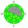
BOTTOM LINE
Danger by aspect and elevation on slopes approaching 35° or steeper.
(click HERE for tomorrow's danger rating)
|

Danger Rose Tutorial
|
A Level 3 (CONSIDERABLE) avalanche danger exists at mid and upper elevations, particularly on slopes facing West, Northwest, North, Northeast, and East. Deep, dangerous, and possibly unsurvivable human triggered avalanches breaking into the widespread and persistent layer of buried surface hoar are likely. These are very unusual avalanche conditions for us and we’re seeing avalanches triggered on relatively low angle slopes, breaking in thick stands of trees, islands of safety, and in terrain where we don’t normally see avalanche activity!
As the day heats up, especially if the sun comes out for any length of time, the danger of wet avalanches will rapidly increase from a Level 1 (LOW) to Level 2 (MODERATE), especially during the heat of the day. Human triggered avalanches will be possible on steep slopes, particularly at lower elevations.
If you’re traveling along the high ridges in the wind zone above treeline, expect to find a Level 2 (MODERATE) avalanche danger. Human triggered avalanches are possible, particularly on steep wind drifted slopes in terrain facing the north half of the compass. |
|
|
CURRENT CONDITIONS |

|
A westerly over the region ushered in clouds overnight, keeping temperatures quite mild. Currently it’s 30 degrees at all but the highest elevations which got down to the mid 20’s overnight. Southwest winds remained busy through the night and are blowing 25-35 mph along the high ridges. It’s a mixed bag out there today though away from the more popular riding areas you should still be able to find soft settled powder on wind sheltered north facing slopes. |
|
|
RECENT ACTIVITY |

|
It's been a busy week-
Wednesday a very knowledgeable and experienced sledder triggered a hard slab 3' deep and 200' wide, while stuck in a tight spot near the top of the slope. The slide carried the rider through a group of trees where he was partially buried, but quickly dug out by his partners. He did, however, sustain some leg injuries and we wish him a speedy recovery. Click here for an accident and snowpack summary.
Also, it’s been an active week in Weber Canyon with two large human triggered slides in the past few days. The first occurred late Saturday on a 33 degree Northwest facing slope at about 9,200’. Averaging 3’ deep and 150’ wide, this remotely triggered slide broke on facets and decomposing surface hoar below the raincrust. Click here for more details.
Tuesday, a local backcountry skier remotely triggered a hard slab from about 75’ away on a Northwest facing slope at 10,000’ near Slader Ridge. 2’-3’ deep and several hundred feet wide, the slide occurred when the second skier was eight turns downslope. Thanks for the great write up JG... click here for more details and here for a snowpack summary..
Huge thanks to all those who continue to submit all the very informative observations. The information is GREATLY appreciated! |
|
|
THREAT #1 |

|
| WHERE |
PROBABILITY |
SIZE |
TREND |

|
|
|
|
| |
|
|
Over the next
24 hours.
|
|
|
My colleagues and I spent most of the week catching up looking at a number of different human triggered slides throughout the range. All of the avalanches are breaking below the January rain-crust, failing on buried surface hoar and are certainly big enough to kill a person. These aren’t steep, radical slopes. These are slopes we wouldn’t think twice about riding… terrain in the 31-33 degree range. The structural setup of our snowpack is tricky to say the least. A dense, cohesive slab, now 3’-4’ deep, sits on a rain-crust that is connected across the slope and to the ridgelines, and all of this rests on weak snow underneath. Unlike our usual snowpack which is shallow, weak, and punchy this is the type of snowpack that feels bomber and supportable under our skis, board, or sled. With the “go anywhere” strength of the pack we’re getting into steep avalanche prone terrain and in most cases getting away with it….and that’s how the avalanche dragon lures you deeper into its den. This perfect storm of layers is particularly sketchy because it gives a false sense of stability, but if you’re not digging into the snowpack carefully analyzing what you’re riding on, you’re just rolling the dice and there’s a reason Vegas is making lots of money. It doesn’t mean you can’t go out and have fun day. It does mean you’ll need to tone it down, ride defensively and only have one person on the slope at a time. Watch your partner from a safe distance and above all, think about the consequences of triggering an avalanche and match your terrain choices accordingly. Remember- avalanches can be triggered from a distance even on relatively low angle terrain so be aware of steep slopes above and those connected to the terrain you’re riding in. |
|
|
THREAT #2 |

|
| WHERE |
PROBABILITY |
SIZE |
TREND |
|
|
|
|
| |
|
|
Over the next
24 hours.
|
|
|
A marginal refreeze overnight combined with today's warm temperatures will increase the danger of wet avalanches. There may not be much direct sun, but as the day heats up, you’ll want to get off of steep, lower elevation slopes, especially if the snow is becoming damp and gloppy. Also, avoid terrain traps like gullies, creek bottoms, and road cuts where avalanche debris can pile up deeply. |
|
|
THREAT #3 |

|
| WHERE |
PROBABILITY |
SIZE |
TREND |
|
|
|
|
| |
|
|
Over the next
24 hours.
|
|
|
Southerly winds gusted into the 70’s along the ridges on Thursday night, creating stubborn wind drifts along the leeward side of upper elevation ridges and these may still be reactive to the weight of a rider. Once triggered, today’s slabs could break into weaker layers of snow creating a large, unmanageable slide. Continue avoiding steep, wind drifted slopes, especially if they appear fat and rounded or sound hollow like a drum. In addition, cornices are huge and may break further back than you might expect. |
|
|
MOUNTAIN WEATHER |

|
A series of weak disturbances embedded in a westerly flow will bring light snow to the area over the next couple of days. None of the storms looks particularly big. Today we can expect mostly cloudy skies with sun poking through at times this afternoon. Highs reach into the mid 30’s with overnight lows dipping into the low 20’s. West and southwest winds mellowed out through the day, blowing in the 15-25 mph range. A couple inches of snow is possible overnight with a similar day slated for tomorrow. |
|
|
GENERAL ANNOUNCEMENTS |
The information in this advisory expires 24 hours after the date and time posted, but will be updated by 7:00 AM Sunday, Mar. 13th, 2011.
If you’re getting out and about and trigger an avalanche or see anything interesting please let us know here. Or drop Craig an email : craig@utahavalanchecenter.org or call 801-231-2170
The western Uinta advisory program is going full tilt and forecasts will be issued by 7:00 AM on Wednesday, Saturday, Sunday and all holidays. |
|
|
This information does not apply to developed ski areas or highways where avalanche control is normally done. This advisory is from the U.S.D.A. Forest Service, which is solely responsible for its content. This advisory describes general avalanche conditions and local variations always occur. |
|
This advisory provided by the USDA Forest Service, in partnership with:
The Friends of the Utah Avalanche Center, Utah Division of State Parks and Recreation, Utah Division of Emergency Management, Salt Lake County, Salt Lake Unified Fire Authority and the friends of the La Sal Avalanche Center. See our Sponsors Page for a complete list. |
