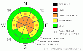
BOTTOM LINE
Danger by aspect and elevation on slopes approaching 35° or steeper.
(click HERE for tomorrow's danger rating)
|
Danger Rose Tutorial
|
If you’re traveling along the high ridges in the wind zone above treeline, expect to find a Level 3 (CONSIDERABLE) avalanche danger. Human triggered avalanches are likely, particularly on steep wind drifted slopes in terrain facing the north half of the compass. At mid elevations, a Level 2 (MODERATE) avalanche danger exists and human triggered avalanches are possible on steep leeward slopes.
In addition, our widespread and persistent layer of surface hoar still exists throughout the range and human triggered avalanches can break into this deeply buried weak layer, creating a large and dangerous avalanche. This problematic weak layer is most prevalent on mid and upper elevation slopes facing West, Northwest, North, Northeast, and East. While not widespread, if you’re getting into terrain with a thinner snowpack, you’ll encounter pockets of Level 3 (CONSIDERABLE) danger.
Out of the wind in mid and low elevation terrain a Level 1 (LOW) avalanche danger exists. |
|
|
CURRENT CONDITIONS |

|
A weak storm system brushing by the region has ushered in clouds and a few light snow showers. West and southwest winds increased around 9:00 last night and have been blowing 25-35 mph, though there were a few hours of gusts to 40 mph. Temperatures are in the low to mid 20’s. Monday’s storm stacked up over a foot of new snow and the coverage on the Eastern Front is about as good as it gets. While many sunny slopes picked up some heat yesterday and will have a slight surface crust, mid and upper elevation, shady slopes will be cold, creamy, and deep. |
|
|
RECENT ACTIVITY |

|
It’s been an active week in Weber Canyon with two large human triggered slides in the past few days. The first occurred late Saturday on a 33 degree Northwest facing slope at about 9,200’. Averaging 3’ deep and 150’ wide, this remotely triggered slide broke on facets and decomposing surface hoar below the raincrust. Click here for more details.
Yesterday, a very knowledgeable and experienced backcountry skier remotely triggered a hard slab from about 75’ away on a Northwest facing slope at 10,000’ near Slader Ridge. 2’-3’ deep and several hundred feet wide, the slide occurred when the second skier was eight turns downslope. Thanks for the great write up JG! Click here for more details.
Huge thanks to all those who continue to submit all the very informative observations. The information is GREATLY appreciated! |
|
|
THREAT #1 |

|
| WHERE |
PROBABILITY |
SIZE |
TREND |
|
|
|
|
| |
|
|
Over the next
24 hours.
|
|
|
With plenty of new snow available for transport, last night’s winds will have formed sensitive slabs along the leeward side of upper elevation ridges. While mostly manageable in size to begin with, today’s fresh drifts could break into weaker snow once triggered and create a larger slide than you might expect. Today, I’d continue avoiding any fat looking, rounded pillow of snow, especially on steep mid and upper elevation slopes facing the north half of the compass. Check out Ted's great obs from Whitney Basin describing the situation. |
|
|
THREAT #2 |

|
| WHERE |
PROBABILITY |
SIZE |
TREND |

|
|
|
|
| |
|
|
Over the next
24 hours.
|
|
|
The bigger, scarier, and less manageable issue in our snowpack centers around the now deeply buried raincrust and the facet/ surface hoar combo which lurks underneath. All the recent large slides we’ve looked at have a common theme- a dense slab, now 3’-4’ deep, sits on a slick bed surface and all of this rests on weak snow underneath. The structural makeup of our snowpack is not only inherently spooky, it’s tricky because you can ride plenty of slopes and not trigger a large dangerous slide, but move over a couple hundred feet and BAM… you’ve got a huge avalanche on your hands. Wow….how do you safely travel around the mountains with conditions like that. If you’re not into geeking out digging lots of snowpits to get a feeling on what kind of avalanche dragon you’re dealing with, then you need to ride defensively. That means only putting one person on the slope at a time and having an escape route planned. Also, avoid thinner looking portions of the snowpack where bushes, rocks, or small trees are poking through, especially if that’s connected to a steeper slope. Finally, think about the consequences of triggering a slide and chose terrain accordingly. |
|
|
MOUNTAIN WEATHER |

|
After a few early morning flurries, high pressure builds into the region today, giving us partly cloudy skies with temperatures warming into the low to mid 30’s. Westerly winds remain reasonable, averaging 15-25 mph with a few gusts in the low 40’s along the highest ridges. Under clearing skies, overnight lows dip into the mid teens. A warm day is on tap for Thursday, before a weak system passes through the region Thursday night, giving us a couple inches of snow. A westerly flow over the area brings a chance for on again, off again, light snow through the weekend. |
|
|
GENERAL ANNOUNCEMENTS |
The information in this advisory expires 24 hours after the date and time posted, but will be updated by 7:00 AM Saturday, Mar. 12th, 2011.
If you’re getting out and about and trigger an avalanche or see anything interesting please let us know here. Or drop Craig an email : craig@utahavalanchecenter.org or call 801-231-2170
The western Uinta advisory program is going full tilt and forecasts will be issued by 7:00 AM on Wednesday, Saturday, Sunday and all holidays. |
|
|
This information does not apply to developed ski areas or highways where avalanche control is normally done. This advisory is from the U.S.D.A. Forest Service, which is solely responsible for its content. This advisory describes general avalanche conditions and local variations always occur. |
|
This advisory provided by the USDA Forest Service, in partnership with:
The Friends of the Utah Avalanche Center, Utah Division of State Parks and Recreation, Utah Division of Emergency Management, Salt Lake County, Salt Lake Unified Fire Authority and the friends of the La Sal Avalanche Center. See our Sponsors Page for a complete list. |
