BOTTOM LINE
Danger by aspect and elevation on slopes approaching 35° or steeper.
(click HERE for tomorrow's danger rating)
|
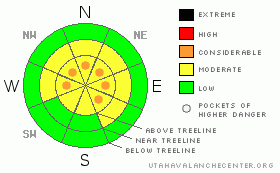
Danger Rose Tutorial
|
At mid and upper elevations, a Level 2 (MODERATE) avalanche danger exists and human triggered avalanches are possible on steep leeward slopes. If you’re traveling along the high ridges in the wind zone above treeline, pockets of Level 3 (CONSIDERABLE) danger exist particularly on steep wind drifted slopes in terrain facing the north half of the compass
In addition, while well behaved at the moment, our widespread and persistent layer of surface hoar still exists throughout the range and human triggered avalanches can break into this deeply buried weak layer, creating a large and dangerous avalanche. This problematic weak layer is most prevalent on upper elevation slopes facing Northwest, North, Northeast, and East. In this type of terrain a Level 2 (MODERATE) avalanche danger exists and human triggered avalanches are possible. If you’re getting into steeper, more radical upper elevation terrain, especially steep rocky slopes with a thinner snowpack, you’ll encounter pockets of Level 3 (CONSIDERABLE) danger.
Out of the wind in mid and low elevation terrain a Level 1 (LOW) avalanche danger exists |
|
|
CURRENT CONDITIONS |

|
Under mostly cloudy skies, temperatures remained quite mild overnight and are currently in the mid to upper 20’s. Southerly winds have been blowing all night 20-30 mph along the high ridges and upper elevation terrain is a bit wind jacked. If you’re looking for soft settled powder, wind sheltered north facing terrain is the ticket. |
|
|
RECENT ACTIVITY |

|
No new avalanches to report, but huge thanks to all those who continue to submit all the very informative observations. The information is GREATLY appreciated! |
|
|
THREAT #1 |

|
| WHERE |
PROBABILITY |
SIZE |
TREND |

|
|
|
|
| |
|
|
Over the next
24 hours.
|
|
|
Fresh wind drifts will be sensitive to the weight of a rider today and these will be found along the leeward side of the high ridges. Gusty winds and additional snow is expected throughout the day and fresh slabs will become more widespread, especially this afternoon as westerly winds increase at the upper elevations. There’s plenty of new snow available for transport, so look for telltale signs of instability like cracking around your sled, skis, or board. In addition, cornices have grown huge and may break back much further than you might expect. Definitely avoid walking out on one to scope out what’s on the other side. Dropping a minivan piece of cornice on a slope below could trigger a larger slide which breaks into deeply buried weak layers. |
|
|
THREAT #2 |

|
| WHERE |
PROBABILITY |
SIZE |
TREND |
|
|
|
|
| |
|
|
Over the next
24 hours.
|
|
|
While the snowpack is gaining strength and the surface hoar seems to be content for the moment, let’s not forget that we’ve still got a persistent buried weak layer lurking in our snowpack. Sure, it’s getting difficult to trigger a large slide that breaks into the buried surface hoar and there are plenty of slopes you can ride and not trigger a deep, scary avalanche. However, if you’re getting into steep, radical terrain where the pack is slightly thinner, especially if there are rocks, trees, or bushes poking through the snow, you may still be able to punch through the raincrust, collapse the slope and trigger a deep avalanche. Check out what Ted and I found by clicking here. |
|
|
MOUNTAIN WEATHER |

|
A moist pacific storm system will bring periods of snow to the region through this evening. Winds will blow out of the west and southwest, 15-30 mph with a few gusts in the 40’s along the high ridges. Temperatures climb into the low to mid 30’s before diving into the teens tonight. We can expect 2”-4” of snow today and then a brief break is expected late tonight through Monday morning, before a colder system brings additional heavy snowfall Monday afternoon through Monday night. Looks like a good shot of snow for us and 12"-18" of new snow by Tuesday morning is a safe bet. Dry and warm conditions are expected for midweek. |
|
|
GENERAL ANNOUNCEMENTS |
The information in this advisory expires 24 hours after the date and time posted, but will be updated by 7:00 AM Wednesday, Mar. 9th, 2011.
If you’re getting out and about and trigger an avalanche or see anything interesting please let us know here. Or drop Craig an email : craig@utahavalanchecenter.org or call 801-231-2170
The western Uinta advisory program is going full tilt and forecasts will be issued by 7:00 AM on Wednesday, Saturday, Sunday and all holidays. |
|
|
This information does not apply to developed ski areas or highways where avalanche control is normally done. This advisory is from the U.S.D.A. Forest Service, which is solely responsible for its content. This advisory describes general avalanche conditions and local variations always occur. |
|
This advisory provided by the USDA Forest Service, in partnership with:
The Friends of the Utah Avalanche Center, Utah Division of State Parks and Recreation, Utah Division of Emergency Management, Salt Lake County, Salt Lake Unified Fire Authority and the friends of the La Sal Avalanche Center. See our Sponsors Page for a complete list. |
