AVALANCHE WARNING »
Dangerous avalanche conditions are occuring or are imminent.
Backcountry travel in avalanche terrain is not recommended.
|
 |
Notice: An Avalanche Warning is in effect for the western Uinta Mountains. Strong winds coupled with new snow have lead to several large, natural avalanches. More wind and snow is expected today and tonight and a Level 4 (HIGH) avalanche danger exists. Human triggered and natural avalanches are likely, especially on steep wind drifted slopes at mid and upper elevations. |
|
|
SPECIAL ANNOUNCEMENT |
 |
Our fourth annual Avy Ride, a fundraiser benefitting avalanche outreach and education specifically for snowmobilers, will be held Saturday Feb. 26th. You can get more details by clicking here. |
|
|
BOTTOM LINE
Danger by aspect and elevation on slopes approaching 35° or steeper.
(click HERE for tomorrow's danger rating)
|
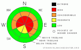
Danger Rose Tutorial
|
At mid and upper elevations especially above treeline, the avalanche danger is Level 4 (HIGH) and dangerous avalanche conditions exist. Both human triggered and natural avalanches are likely, particularly on steep wind drifted slopes in terrain facing the north half of the compass.
In addition, a widespread and persistent layer of surface hoar exists throughout the range and human triggered avalanches can break into this deeply buried weak layer, creating a large and dangerous avalanche. Those without expert snow assessment skills should avoid upper elevation slopes facing Northwest, North, Northeast, and East where a Level 4 (HIGH) avalanche danger exists.
An entirely different avalanche dragon will be found on sunbaked slopes facing the south half of the compass. A Level 2 (MODERATE) avalanche danger exists on these slopes and human triggered new snow along with manageable soft slab avalanches are possible.
A Level 1 (LOW) danger exists on low angle, low elevation terrain, especially those with no steep slopes above or adjacent to where you’re riding. |
|
|
CURRENT CONDITIONS |

|
The storm started marching into the region overnight and 6” of medium density new snow has fallen so far. Winds blew for most of Thursday, averaging 30 mph with gusts in the 50’s, but mellowed out around midnight, backing off into the 20’s and 30’s. Current temperatures are in the mid to upper teens. |
|
|
RECENT ACTIVITY |

|
Two large natural slides, breaking into old snow have been recently reported. One avalanche, 3’-4’ deep and 200’ wide, occurred on a steep, northeast facing slope near Chalk Creek in upper Mill Fork. The other slide occurred in the Superbowl. I don’t have dimensions, but it’s reported to be the largest a few riders have ever seen there.
A very close call last Thursday that involved six sledders & a human triggered avalanche on the North Slope. No injuries were reported although a few sleds had to be towed out after being damaged by the slide. As the weekend progressed we went through a natural avalanche cycle that saw crowns up to 3' in depth.
Big thanks to all those who submitted observations. The information is GREATLY appreciated! |
|
|
THREAT #1 |

|
| WHERE |
PROBABILITY |
SIZE |
TREND |
|
|
|
|
| |
|
|
Over the next
24 hours.
|
|
|
Wind drifts, already several feet deep, will be sensitive to the weight of a rider today. Once triggered, avalanches may break deeper into buried weak layers, creating a large an unmanageable avalanche. Today you’ll need to avoid any steep wind drifted slope, especially in mid and upper elevation terrain facing the north half of the compass. Gather as much information as you can and tweak small test slopes to see how they’re reacting before heading into bigger terrain. Rather than just rolling the dice, use this information to help dictate your terrain choices. Look for clues like shooting cracks, whoomphing sounds, and of course recent avalanches. |
|
|
THREAT #2 |

|
| WHERE |
PROBABILITY |
SIZE |
TREND |
|
|
|
|
| |
|
|
Over the next
24 hours.
|
|
|
Natural avalanches are already starting to break into older snow, failing on the layer of buried surface hoar. Very tricky avalanche conditions exist and today’s slides have the potential to be dangerously large, scary and unsurvivable. If you are getting out on the snow, stick to low angle slopes or meadows, especially those with no steep slopes above or connected to where you’re riding. Also, you’ll need to avoid avalanche runout zones. |
|
|
MOUNTAIN WEATHER |

|
Snow this morning should continue to stack up and we can expect an additional 6” before things taper off later this morning. South and southwest winds remain manageable during the day, but will ramp up this afternoon and blow in the 30’s and 40’s. Temperatures climb into the mid to upper 20’s before diving into the teens tonight. Another similar wave impacts the region again tonight into midday Saturday, before shifting to the east. |
|
|
GENERAL ANNOUNCEMENTS |
The information in this advisory expires 24 hours after the date and time posted, but will be updated by 7:00 AM Saturday, Feb. 26th, 2011.
If you’re getting out and about and trigger an avalanche or see anything interesting please let us know here. Or drop Craig an email : craig@utahavalanchecenter.org or call 801-231-2170
The western Uinta advisory program is going full tilt and forecasts will be issued by 7:00 AM on Wednesday, Saturday, Sunday and all holidays. |
|
|
This information does not apply to developed ski areas or highways where avalanche control is normally done. This advisory is from the U.S.D.A. Forest Service, which is solely responsible for its content. This advisory describes general avalanche conditions and local variations always occur. |
|
This advisory provided by the USDA Forest Service, in partnership with:
The Friends of the Utah Avalanche Center, Utah Division of State Parks and Recreation, Utah Division of Emergency Management, Salt Lake County, Salt Lake Unified Fire Authority and the friends of the La Sal Avalanche Center. See our Sponsors Page for a complete list. |
