AVALANCHE WARNING »
Dangerous avalanche conditions are occuring or are imminent.
Backcountry travel in avalanche terrain is not recommended.
|
 |
Notice: An Avalanche Warning remains in effect for the western Uinta Mountains. Strong winds, coupled with over two feet of new snowfall have created dangerous avalanche conditions. Deep, dangerous, human triggered avalanches are likely, especially on steep wind drifted, upper elevation slopes. |
|
|
SPECIAL ANNOUNCEMENT |
 |
Our fourth annual Avy Ride, a fundraiser benefitting avalanche outreach and education specifically for snowmobilers, will be held Saturday Feb. 26th. You can get more details by clicking here. |
|
|
BOTTOM LINE
Danger by aspect and elevation on slopes approaching 35° or steeper.
(click HERE for tomorrow's danger rating)
|
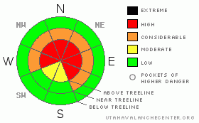
Danger Rose Tutorial
|
A Level 4 (HIGH) avalanche danger exists on all steep, upper elevation wind drifted slopes and human triggered avalanches are likely. You’ll find this condition most prevalent on slopes facing the north half of the compass.
In addition, avalanches can break deeply into the buried surface hoar layer and a Level 3 (CONSIDERABLE) avalanche danger exists at mid and upper elevations on slopes facing Northwest, North, Northeast, and East. Avalanches breaking to the surface hoar layer will be deep, dangerous and possibly unsurvivable.
A Level 1 (LOW) danger exists on low angle, low elevation terrain, especially those with no steep slopes above or adjacent to where you’re riding. |
|
|
CURRENT CONDITIONS |

|
In the wake of yesterday’s storm, skies are mostly cloudy this morning and a few snow showers linger over the region. New snow totals in the past 24 hours are pretty evenly distributed across the range and 16” is the norm, though some favored areas around the North Slope received closer to two feet. West and southwest winds remained active through the night, averaging 25 mph with a gust or two in the 40’s. They’ve backed off slightly and are currently blowing 20-30 mph along the high ridges. Temperatures are in the upper single digits and low teens. The storm snow has settled slightly, making for easier travel and ridiculously deep riding conditions. |
|
|
RECENT ACTIVITY |

|
Visibility was limited yesterday, but from what we could see, at the very minimum, the region experienced a widespread new snow, natural avalanche cycle.
In addition, Ted and Justin rallied to investigate Thursday’s large avalanche near Humpy Peak. One rider was climbing the slope when he triggered the slide that partially buried several other riders waiting at the bottom, damaging sleds and leaving everyone pretty shook up. Fortunately all came out unscathed. Click here for more details regarding this very close call. Ted is a vital part of the UAC team and I want to thank him for all his hard work and great observations!
On Friday, Ted and I found a very large natural avalanche in the Chalk Creek drainage. The slide was only a few hours old and occurred on a heavily wind loaded, north facing slope at about 10,400’. While the crown rapidly filled in, we could see the avalanche broke to the ground on a steep, rocky breakover, taking out the entire season’s snowpack, knocking over small trees and running about 600 vertical feet.
Click here for more snowpack and avalanche observations.
Avalanche observations are always appreciated, and they help to inform others which saves lives. If you trigger an avalanche please let us know about it. Remember, observers may choose to remain anonymous if they wish. |
|
|
THREAT #1 |

|
| WHERE |
PROBABILITY |
SIZE |
TREND |

|
|
|
|
| |
|
|
Over the next
24 hours.
|
|
|
Wind drifted snow along the ridges will remain sensitive to the weight of a rider today. Once triggered, today’s avalanches can break into weaker layers of snow, now buried several feet deep in the snowpack, resulting in a large and dangerous avalanche. Today you’ll need to tone it down, exercise patience and avoid any steep wind drifted slope. That doesn’t mean you can’t have fun. It’s insanely deep and you’ll have a blast carving turns on low angle terrain where it’ll be over- the- hood and over- the- head. |
|
|
THREAT #2 |

|
| WHERE |
PROBABILITY |
SIZE |
TREND |

|
|
|
|
| |
|
|
Over the next
24 hours.
|
|
|
Today will be an intoxicating blend of fresh powder, clearing skies, and a holiday with lots of people crawling all over the mountains. Unfortunately, we’ve also got a sketchy snowpack and nothing has changed with our problem child, the buried and preserved surface hoar. In fact, if anything, all the new storm snow will irritate this notoriously tricky weak layer, making it cranky and reactive. Sure you can ride plenty of steep slopes without a worry, but when all the right components come together, once triggered you’ll be staring down the barrel of a very dangerous avalanche.
Since January 20th there have been close to a dozen human triggered avalanches that we know of, all breaking on the surface hoar layer, resulting in several partial burials, one complete burial and numerous close calls. It’s a trainwreck out there and unless we start changing our riding habits someone is going to get severely injured or worse yet, not come home alive to their family at the end of the day. In conditions like these you gotta ride defensively and you’ll need to be on your “A” game. That means only having one person on the slope at a time and watching your partner from a distance at a safe location. Also, even if you’re on low angle terrain think about steep slopes above and connected to the slopes you’re riding on. Above all, think about the consequences of triggering an avalanche and have an escape route planned. |
|
|
MOUNTAIN WEATHER |

|
Weak high pressure tries to develop over the region today and we should see clearing skies throughout the morning hours into early afternoon. West and southwest winds remain well behaved today, averaging 10-20 mph with a few gusts in the low 30’s along the highest ridges. Temperatures climb into the mid 20’s before dipping into the single digits tonight. A little moisture creeps into the area late tonight and tomorrow, bringing mostly cloudy skies and a slight chance of snow. The computer models are waffling a bit regarding a moist westerly flow for later in the week and we should have a better handle on the upcoming pattern for Wednesday’s midweek update. |
|
|
GENERAL ANNOUNCEMENTS |
The information in this advisory expires 24 hours after the date and time posted, but will be updated by 7:00 AM Wednesday, Feb. 23th, 2011.
If you’re getting out and about and trigger an avalanche or see anything interesting please let us know here. Or drop Craig an email : craig@utahavalanchecenter.org or call 801-231-2170
The western Uinta advisory program is going full tilt and forecasts will be issued by 7:00 AM on Wednesday, Saturday, Sunday and all holidays. |
|
|
This information does not apply to developed ski areas or highways where avalanche control is normally done. This advisory is from the U.S.D.A. Forest Service, which is solely responsible for its content. This advisory describes general avalanche conditions and local variations always occur. |
|
This advisory provided by the USDA Forest Service, in partnership with:
The Friends of the Utah Avalanche Center, Utah Division of State Parks and Recreation, Utah Division of Emergency Management, Salt Lake County, Salt Lake Unified Fire Authority and the friends of the La Sal Avalanche Center. See our Sponsors Page for a complete list. |
