SPECIAL ANNOUNCEMENT |
 |
Our fourth annual Avy Ride, a fundraiser benefitting avalanche outreach and education specifically for snowmobilers, will be held Saturday Feb. 26th. We’re still working some elements out on our website, but you can get more details by clicking here. |
|
|
BOTTOM LINE
Danger by aspect and elevation on slopes approaching 35° or steeper.
(click HERE for tomorrow's danger rating)
|
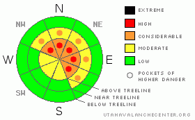
Danger Rose Tutorial
|
A Level 3 (CONSIDERABLE) avalanche danger exists on all steep, wind drifted slopes at and above treeline and human triggered avalanches are likely. In the wind zone along the highest ridges, pockets of Level 4 (HIGH) avalanche danger exist. Along with human triggered slides, natural avalanches are likely.
In addition, avalanches can break deeply into the buried surface hoar layer and a Level 3 (CONSIDERABLE) avalanche danger exists at mid and upper elevations on slopes facing Northwest, North, Northeast, and East. Avalanches breaking to the surface hoar layer will be deep, dangerous and possibly unsurvivable.
A Level 1 (LOW) danger exists on low angle terrain, especially those with no steep slopes above or adjacent to where you’re riding. |
|
|
CURRENT CONDITIONS |

|
Skies are partly cloudy and temperatures are in the upper 20’s and low 30’s. Southeast winds have been blowing relentlessly for days and currently they’re still cranking 40-60 mph along the high ridges. Riding and turning conditions are a mixed bag and much of the upper elevation terrain is severely damaged and wind jacked. Though mid elevation, wind protected slopes still offer good soft settled powder riding conditions. |
|
|
RECENT ACTIVITY |

|
It’s been an active week in the western Uinta’s. Yesterday Ted and I found a very large natural avalanche in the Chalk Creek drainage. The slide was only a few hours old and occurred on a steep, heavily wind loaded, north facing slope at about 10,400’. While the crown rapidly filled in, we could see the avalanche broke to the ground on a steep, rocky breakover, taking out the entire season’s snowpack, knocking over trees and running about 600 vertical feet.
In addition, we’re chasing down leads regarding a very close call that occurred sometime Thursday near Humpy Peak where six sledders were involved in a large slide that partially buried several riders, damaging sleds and leaving the partly quite shaken up. Fortunately all came out unscathed.
Click here for more snowpack and avalanche observations.
Avalanche observations are always appreciated, and they help to inform others which saves lives. If you trigger an avalanche please let us know about it. Remember, observers may choose to remain anonymous if they wish. |
|
|
THREAT #1 |

|
| WHERE |
PROBABILITY |
SIZE |
TREND |
|
|
|
|
| |
|
|
Over the next
24 hours.
|
|
|
The punishing winds continue to form thick slabs that are breaking with the additional weight of a rider. Found not only along the leeward side of ridges, but also much lower down slope and around terrain features like chutes, gullies, and sub-ridges, today’s wind slabs can break wider and deeper than you might expect, creating a very dangerous avalanche. Easy to detect and avoid, steer clear of any recently wind loaded slope, especially if the snow feels or sounds hollow like a drum. |
|
|
THREAT #2 |

|
| WHERE |
PROBABILITY |
SIZE |
TREND |

|
|
|
|
| |
|
|
Over the next
24 hours.
|
|
|
The more insidious avalanche dragon lurking in the snowpack is the buried and preserved surface hoar. Ted and I found it alive, well, and reactive in our snowpits yesterday. This is a weak layer of snow we’re not used to dealing with and avalanche conditions remain deceptively tricky. Sure you can ride plenty of steep slopes without a worry, but when all the right components come together, once triggered you’ll be staring down the barrel of a very dangerous avalanche.
Since January 20th there have been close to a dozen human triggered avalanches that we know of, all breaking on the surface hoar layer, resulting in several partial burials, one complete burial and numerous close calls. It’s a trainwreck out there and unless we start changing our riding habits someone is going to get severely injured or worse yet, not come home alive to their family at the end of the day. In conditions like these you gotta ride defensively and you’ll need to be on your “A” game. That means only having one person on the slope at a time and watching your partner from a distance at a safe location. Also, even if you’re on low angle terrain think about steep slopes above and connected to the slopes you’re riding on. Above all, think about the consequences of triggering an avalanche and have an escape route planned. |
|
|
MOUNTAIN WEATHER |

|
Clouds, wind, and snow are all on tap for today as a storm system to the south slides through the region. We can expect 2”-6” of snow today, with the same amounts slated for tonight and Sunday. Southerly winds will be obnoxious, blowing 15-30 mph with gusts in the 50’s along the high ridges. Temperatures remain mild with highs reaching into the mid 30’s and overnight lows dipping into the mid 20’s. Skies clear out for President’s Day and a good looking storm is taking shape for mid week. |
|
|
GENERAL ANNOUNCEMENTS |
The information in this advisory expires 24 hours after the date and time posted, but will be updated by 7:00 AM Sunday, Feb. 20th, 2011.
If you’re getting out and about and trigger an avalanche or see anything interesting please let us know here. Or drop Craig an email : craig@utahavalanchecenter.org or call 801-231-2170
The western Uinta advisory program is going full tilt and forecasts will be issued by 7:00 AM on Wednesday, Saturday, Sunday and all holidays. |
|
|
This information does not apply to developed ski areas or highways where avalanche control is normally done. This advisory is from the U.S.D.A. Forest Service, which is solely responsible for its content. This advisory describes general avalanche conditions and local variations always occur. |
|
This advisory provided by the USDA Forest Service, in partnership with:
The Friends of the Utah Avalanche Center, Utah Division of State Parks and Recreation, Utah Division of Emergency Management, Salt Lake County, Salt Lake Unified Fire Authority and the friends of the La Sal Avalanche Center. See our Sponsors Page for a complete list. |
