SPECIAL ANNOUNCEMENT |
 |
Our fourth annual Avy Ride, a fundraiser benefitting avalanche outreach and education specifically for snowmobilers, will be held Saturday Feb. 26th. We’re still working some elements out on our website, but you can get more details by clicking here. |
|
|
BOTTOM LINE
Danger by aspect and elevation on slopes approaching 35° or steeper.
(click HERE for tomorrow's danger rating)
|
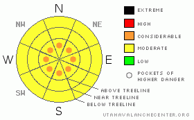
Danger Rose Tutorial
|
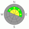
There is currently a Level 2 (Moderate) avalanche hazard associated with unevenly distributed wind slabs at and above treeline.
As we move into Wednesday night the avalanche danger will creep up to Level 3 (Considerable) and stay there for most of the day Thursday as the new snow interacts with the old snow surface.
Then there's our sleeping dragon, the buried surface hoar. Currently there is a Level 2 (Moderate) danger at mid & upper elevations on slopes facing NW, N, NE & E. The chances of triggering a large destructive avalanche failing in the surface hoar will rise as the storm snow accumulates. |
|
|
CURRENT CONDITIONS |

|
Old tracks and wind damaged snow dominate the snow surface. The Uintas are in desperate need of a refresher, and that's just what the range will get this evening. Winter makes its return tonight in the form of a great looking storm that should bring around a foot of snow to the Fx area. Not only that, but it looks like we're back in the good graces of the Jet Stream which should bring us consistent storms for the foreseeable future. Big southerly winds are ripping across the high peaks in advance of the storm at 35 mph gusting to 60 mph. Temperatures are mild across the range hovering just below freezing in most locations. |
|
|
RECENT ACTIVITY |

|
There's been a smattering of recent avalanche activity. Last week there was a large human triggered avalanche in the Chalk Creek area failing on preserved surface hoar. This impressive avalanche weighed in at 2.5 - 4 feet deep and over 600 feet wide.
We got some fairly vague second hand information about an accident on the north slope of the range that apparently occurred Sunday. But, we've been unable to confirm any of the details nor locate the avalanche. Avalanche observations are always appreciated, and they help to inform others which saves lives. If you trigger an avalanche please let us know about it. Remember, observers may choose to remain anonymous if they wish. |
|
|
THREAT #1 |

|
| WHERE |
PROBABILITY |
SIZE |
TREND |

|
|
|
|
| |
|
|
Over the next
48 hours.
|
|
|
We've had some big winds as of late but there really isn't much soft snow available for wind slab formation at the moment. For Wednesday daylight hours this will be a manageable hazard confined to open slopes at & above treeline.
As we move into Thurs/Fri the wind slabs will be of a much different breed. You will need to watch for fresh sensitive wind slabs formed in the new snow. The best strategy will be to ride down low well away from open slopes and avalanche paths. The new snow will be falling on a weak snow surface, and it will need a couple days to settle out. |
|
|
THREAT #2 |

|
| WHERE |
PROBABILITY |
SIZE |
TREND |
|
|
|
|
| |
|
|
Over the next
24
hours.
|
|
|
In the last week we've seen a few avalanches breaking into the surface hoar (SH) which is buried about 3 feet deep on average. There is a rain crust on top of the SH which is keeping it well preserved and helping to keep most of the load off of it. This structure is going to be with us for the long haul at this point. But, that's all academic.
The meat & potatoes of the situation is this: We've got a 3 foot slab on top of a very weak layer. We're lining up for a classic series of Utah storms right now that are going to start stacking on the weight. Will the first storm be enough to start a large avalanche cycle? Probably not. Will it be the second system? I'm not sure. Really, no one is. It might be the 3rd, but at some point, we're going to reach the breaking point, and it's going to be ugly.
These kinds of conditions have been prevalent in British Columbia for the last several seasons. This is a big reason why they have accidents that involve multiple people, because this type of problem isn't obvious when you look at the snow surface. Combine that with the fact that you can go and center punch a dozen slopes without incident, and then wham, you find the weak spot in the snowpack and pull out a very large and destructive avalanche.
So, it's about to get very tricky out there. By staying away from the big slopes, you can avoid a potentially large & destructive avalanche. The great thing about sledding is that you can always track up the meadows and have a great time ripping around on the machine while staying off of & away from the big slopes. But, many will want to head for the bigger terrain which is now a very high risk activity. Be sure that you're fully aware of the consequences before pointing your machine towards the big stuff. |
|
|
THREAT #3 |

|
| WHERE |
PROBABILITY |
SIZE |
TREND |

|
|
|
|
| |
|
|
Over the next
48 hours.
|
|
|
We're expecting about a foot of new snow out of this storm. The new snow will be falling on a rotten ol' snow surface so I expect some active sluffing in the storm snow. The avalanche danger will creep up to Considerable overnight and stay that way for most of the day Thursday. Ride hard, but ride smart. Tweak small test slopes to see how the new snow is bonding and steer clear of terrain traps where even a little bit of sluffing snow can pile up quickly. |
|
|
MOUNTAIN WEATHER |

|
Strong southerly winds will continue to blow today ahead of the frontal passage late this afternoon. Winds will continue to rage as it begins to snow in the early evening. Thunder & lightning are expected at dusk as a cold front pushes its way across the mountains. Lightning strikes will herald the return of winter & we're expecting about a foot of snow out of this storm which will be most intense tonight lingering into Thursday. The mercury sinks down to the single digits Thursday night as the storm comes to a close. We get a bit of a break Friday before another storm system heads our way over the holiday weekend. Check back Saturday morning for an updated Forecast. |
|
|
GENERAL ANNOUNCEMENTS |
The information in this advisory expires 24 hours after the date and time posted, but will be updated by 7:00 AM Saturday, Feb. 19th, 2011.
If you’re getting out and about and trigger an avalanche or see anything interesting please let us know here. Or drop Craig an email : craig@utahavalanchecenter.org or call 801-231-2170
The western Uinta advisory program is going full tilt and forecasts will be issued by 7:00 AM on Wednesday, Saturday, Sunday and all holidays. |
|
|
This information does not apply to developed ski areas or highways where avalanche control is normally done. This advisory is from the U.S.D.A. Forest Service, which is solely responsible for its content. This advisory describes general avalanche conditions and local variations always occur. |
|
This advisory provided by the USDA Forest Service, in partnership with:
The Friends of the Utah Avalanche Center, Utah Division of State Parks and Recreation, Utah Division of Emergency Management, Salt Lake County, Salt Lake Unified Fire Authority and the friends of the La Sal Avalanche Center. See our Sponsors Page for a complete list. |
