SPECIAL ANNOUNCEMENT |
 |
Save the date…. and take a date! Our fourth annual Avy Ride, a fundraiser benefitting avalanche outreach and education specifically for snowmobilers, will be held Saturday Feb. 26th. We’re still working some elements out on our website, but you can get more details by clicking here. |
|
|
BOTTOM LINE
Danger by aspect and elevation on slopes approaching 35° or steeper.
(click HERE for tomorrow's danger rating)
|

Danger Rose Tutorial
|
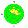
The buried surface hoar hasn't gone away. While the avalanche danger associated with this notoriously tricky layer is a Level 2 (MODERATE), the consequences of triggering an avalanche which fails on the buried surface hoar are severe. These conditions are most prevalent on mid and high elevation slopes facing the north half of the compass.
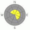
A few fresh wind slabs may be found along the leeward side of upper elevation ridges and these could be sensitive to the weight of a rider. A Level 2 (MODERATE) avalanche danger exists on steep, high elevation, wind drifted slopes.
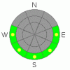
The danger of wet avalanches will increase from Level 1 (LOW) to Level 2 (MODERATE) on steep sunny slopes, especially during the heat of the day. |
|
|
CURRENT CONDITIONS |

|
Strong, west and southwest winds developed overnight along the high ridges, averaging 30 mph with gusts into the low 60’s, as a storm system bumps to the north of the region. Current temperatures are in the upper 20’s and low 30’s across the range and skies are clear. Sunny slopes continue to get baked and are crusted and not quite supportable just yet, but soft settled powder will still be found on mid to upper elevation shady slopes. |
|
|
RECENT ACTIVITY |

|
A large slide was triggered in upper Chalk Creek late Wednesday. The avalanche was 2.5- 4 feet deep and over 600’ wide, breaking below the January rain crust and failing on a layer of perfectly preserved surface hoar. Click here for more details.
Grant and Reid also found similar snowpack conditions in Humpy Creek. Click here to look at that data.
For all Uinta snowpack and avalanche observations click here. |
|
|
THREAT #1 |

|
| WHERE |
PROBABILITY |
SIZE |
TREND |
|
|
|
|
| |
|
|
Over the next
24 hours.
|
|
|
Nothing has changed since yesterday and our problem child, the buried and preserved surface hoar layer remains alive and well. Sure, many steep slopes are getting center punched and ridden without incident. That’s just the problem with a persistent buried weak layer and especially with the snowpack structure we’ve got going on right now. While the surface hoar layer is pretty widespread throughout the range, not every drainage or slope will have the right combination of a slab, a weak layer and a bed surface, so you can ride some steep slopes without triggering avalanches and you’ll be thinking what are the avy guys all sketched out about? However, if you do find a slope where it all comes together, you’ll be able to trigger a scary avalanche that can break on relatively low angle terrain as evidenced by this week’s slide in Chalk Creek. Choosing terrain to match this type of avalanche dragon is difficult, especially if you’re not constantly digging into the snow analyzing the snowpack and its structural characteristics. However, we’ve already done a lot of this work for you and found this tricky condition most prevalent on mid and upper elevation slopes, especially those facing the north half of the compass. If you’re getting into this type of terrain, you gotta ride defensively. That means only having one person on the slope at a time and watching your partner from a distance at a safe location. Also, even if you’re on low angle terrain think about steep slopes above and connected to the slopes you’re riding on. Above all, think about the consequences of triggering an avalanche and have an escape route planned. |
|
|
THREAT #2 |

|
| WHERE |
PROBABILITY |
SIZE |
TREND |
|
|
|
|
| |
|
|
Over the next
24 hours.
|
|
|
Be on the lookout for fresh wind slabs along the leeward side of the highest ridges. While mostly manageable in size and breaking at or below our skis, board or sled, take care one doesn’t take you for an unexpected ride, slamming you into a group of trees or over a cliff. |
|
|
THREAT #3 |

|
| WHERE |
PROBABILITY |
SIZE |
TREND |
|
|
|
|
| |
|
|
Over the next
24 hours.
|
|
|
The sun is high in the sky and steep sun exposed slopes at lower elevations are starting to getting baked. Avoiding wet avalanches is easy. As the snow heats up and gets damp and gloppy, simply get off of steep sunny slopes and avoid terrain traps likes gullies, creek beds, and road cuts where wet avalanche debris can pile up very deeply. |
|
|
MOUNTAIN WEATHER |

|
Clear skies, warm temperatures and obnoxious west-southwest winds are on tap today. Gusting into the 50’s and 60’s along the highest ridges, winds should begin to mellow out by early afternoon. High temperatures reach into the low to mid 40’s with overnight lows dipping into the mid 20’s. High pressure slides east of the region today, allowing a southwest flow to develop, ushering in a series of storms with the first slated to impact the region late Wednesday. At this point it’s tough to say just how potent these systems will be and we’ll have a better handle on strength and timing for Wednesday’s midweek update. |
|
|
GENERAL ANNOUNCEMENTS |
The information in this advisory expires 24 hours after the date and time posted, but will be updated by 7:00 AM Wednesday, Feb. 16th, 2011.
If you’re getting out and about and trigger an avalanche or see anything interesting please let us know here. Or drop Craig an email : craig@utahavalanchecenter.org or call 801-231-2170
The western Uinta advisory program is going full tilt and forecasts will be issued by 7:00 AM on Wednesday, Saturday, Sunday and all holidays. |
|
|
This information does not apply to developed ski areas or highways where avalanche control is normally done. This advisory is from the U.S.D.A. Forest Service, which is solely responsible for its content. This advisory describes general avalanche conditions and local variations always occur. |
|
This advisory provided by the USDA Forest Service, in partnership with:
The Friends of the Utah Avalanche Center, Utah Division of State Parks and Recreation, Utah Division of Emergency Management, Salt Lake County, Salt Lake Unified Fire Authority and the friends of the La Sal Avalanche Center. See our Sponsors Page for a complete list. |
