SPECIAL ANNOUNCEMENT |
 |
Save the date…. and take a date! Our fourth annual Avy Ride, a fundraiser benefitting avalanche outreach and education specifically for snowmobilers, will be held Saturday Feb. 26th. We’re still working some elements out on our website, but you can get more details by clicking here. |
|
|
BOTTOM LINE
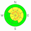
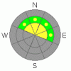
Danger by aspect and elevation on slopes approaching 35° or steeper.
(click HERE for tomorrow's danger rating)
|
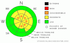
Danger Rose Tutorial
|
Recent winds created slabs which remain sensitive to the additional weight of a rider today. On steep, upper elevation slopes, especially those with an easterly component to their aspect, the avalanche danger is a Level 2 (MODERATE) and human triggered avalanches are possible. In the wind zone along the high ridges, pockets of Level 3 (CONSIDERABLE) avalanche danger exist and human triggered avalanches are likely on steep, wind drifted slopes.
Slopes facing North, Northeast, and East at and above treeline continue to harbor weak surface hoar, now buried several feet below the snow surface. While the chances of triggering an avalanche which breaks into surface hoar is a Level 2 (MODERATE) avalanche danger, the consequences remain serious, particularly as we add more snow and wind to the equation. |
|
|
CURRENT CONDITIONS |

|
A strong northwest flow over the region is ushering in clouds and a few light snow showers. West and northwest winds have mellowed out slightly, blowing 10-20 mph with gusts in the 30’s along the high ridges. Because of yesterday’s raging wind, new snow totals are hard to gauge, but in general it looks like 3” of snow fell in upper elevation terrain around the North Slope with only an inch or two accumulating on the southern half of the range. Temperatures are in the upper teens and low 20’s. Riding and turning conditions are a mixed bag, though you can still find pockets of soft, spongy powder on wind sheltered slopes. |
|
|
RECENT ACTIVITY |

|
It’s been a quiet week on the eastern front with no new avalanche activity to report.
Click here for recent snowpack observations. |
|
|
THREAT #1 |

|
| WHERE |
PROBABILITY |
SIZE |
TREND |
|
|
|
|
| |
|
|
Over the next
24 hours.
|
|
|
Wind slabs were a little more stubborn yesterday than I expected, but I didn’t hang it out in any big terrain to test my theories, especially given the signs of unstable snow like cracking around my sled and skis. I would expect to find similar conditions today and I think you could trigger a decent sized wind slab particularly in terrain above treeline, on slopes with an easterly component to their aspect. While mostly manageable in size to begin with, once triggered, today’s slabs could break into lighter density snow which fell earlier in the week, creating a larger slide than you might’ve bargained for. Today you’ll want to continue avoiding any fat looking rounded pillow of snow, especially if it feels hollow or sounds like a drum. Tweak or stomp on small test slopes and see how they're reacting before getting after the big terrain. |
|
|
THREAT #2 |

|
| WHERE |
PROBABILITY |
SIZE |
TREND |
|
|
|
|
| |
|
|
Over the next
24 hours.
|
|
|
The snowpack’s problem child, the buried and preserved surface hoar, has been relatively well behaved this past week, but we shouldn’t take our eye off this notoriously tricky weak layer. Remember- surface hoar is problematic because each time it’s overloaded with additional snow or wind, it becomes cranky and reactive. While isolated and making up a small portion of our terrain, you can still trigger a slide that breaks several feet deep failing on buried surface hoar. North, Northeast, and East facing terrain, at and above treeline, on slopes approaching 35 degrees in steepness should be considered suspect. |
|
|
MOUNTAIN WEATHER |

|
Today we can expect mostly cloudy skies and increasing west and northwest winds as another wave embedded in the strong northwest flow slides through the region. Winds should be burly by evening with gusts in the 40’s and 50’s along the high ridges. Temperatures peak in the upper 20’s before diving into the teens overnight. Snow develops tonight, though accumulations look spotty and marginal with just about 2”-4” expected. A stronger system moves into the area late Monday and lingers into midday Tuesday. Looks like close to a foot of snow is a good bet before high pressure takes hold for the remainder of the week. |
|
|
GENERAL ANNOUNCEMENTS |
The information in this advisory expires 24 hours after the date and time posted, but will be updated by 7:00 AM Wednesday, Feb. 9th, 2011.
If you’re getting out and about and trigger an avalanche or see anything interesting please let us know here. Or drop Craig an email : craig@utahavalanchecenter.org or call 801-231-2170
The western Uinta advisory program is going full tilt and forecasts will be issued by 7:00 AM on Wednesday, Saturday, Sunday and all holidays. |
|
|
This information does not apply to developed ski areas or highways where avalanche control is normally done. This advisory is from the U.S.D.A. Forest Service, which is solely responsible for its content. This advisory describes general avalanche conditions and local variations always occur. |
|
This advisory provided by the USDA Forest Service, in partnership with:
The Friends of the Utah Avalanche Center, Utah Division of State Parks and Recreation, Utah Division of Emergency Management, Salt Lake County, Salt Lake Unified Fire Authority and the friends of the La Sal Avalanche Center. See our Sponsors Page for a complete list. |
