SPECIAL ANNOUNCEMENT |
 |
Save the date…. and take a date! Our fourth annual Avy Ride, a fundraiser benefitting avalanche outreach and education specifically for snowmobilers, will be held Saturday Feb. 26th. We’re still working some elements out on our website, but you can get more details by clicking here. |
|
|
BOTTOM LINE
Danger by aspect and elevation on slopes approaching 35° or steeper.
(click HERE for tomorrow's danger rating)
|
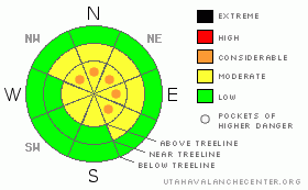
Danger Rose Tutorial
|
Strong winds will continue to create slabs which will be sensitive to the additional weight of a rider today. On steep, upper elevation slopes facing the north half of the compass the avalanche danger is a Level 2 (MODERATE) and human triggered avalanches are possible. In the wind zone along the high ridges, pockets of Level 3 (CONSIDERABLE) avalanche danger exist and human triggered avalanches are likely on steep, wind drifted slopes.
Slopes facing North, Northeast, and East at and above treeline continue to harbor weak surface hoar, now buried several feet below the snow surface. While the chances of triggering an avalanche which breaks into surface hoar is a Level 2 (MODERATE) avalanche danger, the consequences continue to increase, particularly as we add more snow and wind to the equation. |
|
|
CURRENT CONDITIONS |

|
A moist, northwest flow over the region is just starting to kick off snow showers this morning, but accumulations so far are only about an inch or so. Temperatures are mild, in the mid to upper 20’s. The big news is the strong west and southwest winds which developed overnight. In upper elevation terrain winds are blowing 15-30 mph, but along the high ridges they’re cranking, averaging 40 mph, gusting into the 60’s. The past few days winds have been all over the map and much of our terrain is wind jacked and resembles a moonscape, though pockets of soft settled powder can still be found on mid elevation wind sheltered shady slopes. |
|
|
RECENT ACTIVITY |

|
It’s been a quiet week on the eastern front with no new avalanche activity to report.
Click here for recent snowpack observations. |
|
|
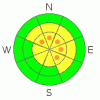
THREAT #1 |

|
| WHERE |
PROBABILITY |
SIZE |
TREND |
|
|
|
|
| |
|
|
Over the next
24 hours.
|
|
|
A series of storms is lining up to impact the region and we’ll see changing avalanche conditions the next few days. The most obvious issue this morning is the fresh wind drifts that are forming along the leeward side of upper elevation ridges. With strong winds on tap, look for drifting further downslope than we usually expect and also for slabs that formed in chutes, gullies, and around sub-ridges. While mostly manageable in size to begin with, once triggered, today’s slabs could break into a whole host of weaker layers, creating a larger slide than you might’ve bargained for. Today you’ll want to avoid any fat looking rounded pillow of snow, especially if it feels hollow or sounds like a drum. In addition, tweak small test slopes and see how they're reacting before getting after the big terrain. |
|
|
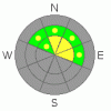
THREAT #2 |

|
| WHERE |
PROBABILITY |
SIZE |
TREND |
|
|
|
|
| |
|
|
Over the next
24 hours.
|
|
|
While this year’s problem child, the buried and preserved surface hoar, has been relatively well behaved this past week, we shouldn’t take our eye of this notoriously tricky weak layer. Remember- surface hoar is problematic because each time it’s overloaded with additional snow or wind, it becomes cranky and reactive. Today you can still trigger a slide that breaks several feet deep failing on the buried surface hoar, especially on North, Northeast and East facing slopes, at and above treeline, in terrain approaching 35 degrees in steepness. |
|
|
MOUNTAIN WEATHER |

|
A weak disturbance keeps snow showers over the area with an additional 2”-4” expected by about sunset. Winds remain a nuisance, blowing out of the west and eventually northwest, at 15-30 mph with gusts in the 50’s and 60’s along the high ridges. They’ll taper off late today as this storm system slides to the southeast. Temperatures remain mild with highs in the mid to upper 20’s and overnight lows in the mid teens. Winds ramp up again overnight and into Sunday as another wave passes over the region late in the day. A well defined cold front with plenty of moisture impacts the area late Monday or Monday night, giving us a good shot of snow which lingers into midweek. More details to follow on tomorrow’s advisory. |
|
|
GENERAL ANNOUNCEMENTS |
The information in this advisory expires 24 hours after the date and time posted, but will be updated by 7:00 AM Sunday, Feb. 6th, 2011.
If you’re getting out and about and trigger an avalanche or see anything interesting please let us know here. Or drop Craig an email : craig@utahavalanchecenter.org or call 801-231-2170
The western Uinta advisory program is going full tilt and forecasts will be issued by 7:00 AM on Wednesday, Saturday, Sunday and all holidays. |
|
|
This information does not apply to developed ski areas or highways where avalanche control is normally done. This advisory is from the U.S.D.A. Forest Service, which is solely responsible for its content. This advisory describes general avalanche conditions and local variations always occur. |
|
This advisory provided by the USDA Forest Service, in partnership with:
The Friends of the Utah Avalanche Center, Utah Division of State Parks and Recreation, Utah Division of Emergency Management, Salt Lake County, Salt Lake Unified Fire Authority and the friends of the La Sal Avalanche Center. See our Sponsors Page for a complete list. |
