BOTTOM LINE
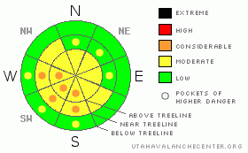
Danger by aspect and elevation on slopes approaching 35° or steeper.
(click HERE for tomorrow's danger rating)
|

Danger Rose Tutorial
|
Unusual winds have created fresh wind slabs above & below treeline on slopes that face S, SW & W. On these slopes there is a mostly Level 2 (Moderate) avalanche danger. On these same slopes there are pockets of Level 3 (Considerable) avalanche danger where fresh wind slabs have been created.
Slopes facing N, NE, & E at and above treeline continue to harbor weak surface hoar a couple feet below the surface. While the chance of triggering an avalanche failing in the old surface hoar is Level 2 (Moderate), the consequences of triggering continue to increase as we add more snow to the equation.
|
|
|
CURRENT CONDITIONS |

|
Brrrrrrr! Temperatures across the region average -15°, with Hayden fork claiming lowest mercury at -27° this morning. Needless to say, the region is under the influence of some frigid Arctic air. We received just 5" of new snow out of Mondays system, which means that you can still see and feel all the old tracks. Winds are strong out of the N-NE; Lofty lake is recording winds at a sustained 57 mph, gusting as high as 70 mph. That makes for a windchill of -61°. Bundle up!
|
|
|
RECENT ACTIVITY |

|
Ted found another avalanche originating in the surface hoar yesterday. Click here for his observations. Thanks so much for braving the brutally cold temperatures long enough to put a great observation together Ted!
|
|
|
THREAT #1 |

|
| WHERE |
PROBABILITY |
SIZE |
TREND |

|
|
|
|
| |
|
|
Over the next
48 hours.
|
|
|
The winds currently have a strong easterly component which is creating some unusual wind loading patterns. You'll need to re-adjust your wind loading mindset today; slopes that face W, SW & S will be harboring fresh wind slabs that will be sensitive to the weight of a rider. Look for visual clues like fat, rounded & pillow like formations that indicate recent wind loading. I expect these slabs to be from 1 - 2' in depth. You will need to watch for them not just up high in the Alpine, but down below treeline even, as yesterday's winds really dug down into our lower elevations. Be sure to tweak small test slopes on the machine before you even think about approaching the big slopes today.
|
|
|
THREAT #2 |

|
| WHERE |
PROBABILITY |
SIZE |
TREND |

|
|
|
|
| |
|
|
Over the next
48 hours.
|
|
|
The surface hoar (SH) dragon certainly hasn't gone away, it's just resting for the time being. Cold temperatures will help to keep it in that state, but the risk of triggering an avalanche originating in the SH is far from zero. This is the ugly low probability of triggering, high consequence if you do scenario. We had 4, possibly even 5 snowmobile triggered avalanches originating in the weak SH layer last week and no doubt, there will be more. This type of avalanche hazard is admittedly very hard to forecast for. There aren't any signs on the surface alerting you to its presence below; you need to dig down and identify it. If that solution doesn't jive with you, then the best thing is to avoid mid & high elevation slopes that face N, NE & E. That may be easier said than done.....
|
|
|
MOUNTAIN WEATHER |

|
It's going to be another brutally cold day in the mountains with a high of 7. Windchill values will be as low as -33. It will be sunny, which means that if you happen to see Craig Gordon, he likely won't be wearing a hat. But, the rest of us really need to bundle up out there & have a plan for warmth in case the sled breaks down. Temperatures begin to moderate overnight & we can expect a much more seasonable high of 26 on Thursday with partly cloudy skies. Thursday night is once again cool with moderate temperatures on Friday. There is a chance of snow Friday evening as a fast moving short wave system brushes by our area. Stay tuned for details.
|
|
|
GENERAL ANNOUNCEMENTS |
The information in this advisory expires 24 hours after the date and time posted, but will be updated by 7:00 AM Saturday, Feb. 5th, 2011.
If you’re getting out and about and trigger an avalanche or see anything interesting please let us know here. Or drop Craig an email : craig@utahavalanchecenter.org or call 801-231-2170
The western Uinta advisory program is going full tilt and forecasts will be issued by 7:00 AM on Wednesday, Saturday, Sunday and all holidays. |
|
|
This information does not apply to developed ski areas or highways where avalanche control is normally done. This advisory is from the U.S.D.A. Forest Service, which is solely responsible for its content. This advisory describes general avalanche conditions and local variations always occur. |
|
This advisory provided by the USDA Forest Service, in partnership with:
The Friends of the Utah Avalanche Center, Utah Division of State Parks and Recreation, Utah Division of Emergency Management, Salt Lake County, Salt Lake Unified Fire Authority and the friends of the La Sal Avalanche Center. See our Sponsors Page for a complete list. |


