Uintas Avalanche Advisory

Forecaster: Grant Helgeson

SPECIAL ANNOUNCEMENT

Along with the rest of the UAC, I offer a big heart felt Thank You to everyone who has sent in photos, observations and avalanche occurrences. This information makes better forecasts & helps to save lives. Thanks again folks! And please keep 'em coming!


BOTTOM LINE

Danger by aspect and elevation on slopes approaching 35° or steeper.
(click HERE for tomorrow's danger rating)


Danger Rose Tutorial

At and above treeline on slopes that face N, NE & E there are pockets of Level 3 (Considerable) avalanche danger. Numerous snowmobile triggered avalanches have occurred in these areas over the past week. All other slopes above treeline have a Level 2 (Moderate) avalanche danger.

At treeline and below there is a Level 2 (Moderate) avalanche danger for wet avalanche activity on slopes that see the most sun, those that face W, SW, S, SE & E.


CURRENT CONDITIONS

Yesterday was a very warm day in the mountains with 9000' temps topping out near 50 F, and 11,000' temps maxing out near freezing. This morning temps are in the upper twenties across the region & winds are light out of the west at 10 mph. Today looks to be another scorcher with temperatures trending the same way they did yesterday.


RECENT ACTIVITY

In the last week there have been 4 snowmobile triggered avalanches reported & many other slides have been observed. The majority of the activity has involved the Jan. 8th surface hoar. This notoriously tricky layer has been failing both mid slope & at the top of the slope, and it some cases has failed in pretty low angle (32 degree) terrain.


THREAT #1

WHERE PROBABILITY SIZE TREND
      Over the next 24 hours.

Where did this nasty layer come from?

It was formed during the string of cold clear nights in early January and is widely distributed across the range. On January 8th we received a small amount of snow that came in without wind and preserved it. At this point, there is 18"- 24" of snow on top of it.

How long will it stay like this?

Unfortunately the surface hoar is super well preserved in our snowpack. It pains me to say it, but, this layer could be with us until it melts in the spring.

What are the consequences of triggering an avalanche in the SH?

Riders are pulling out hard slabs 1.5 - 2 feet in depth. So far, no one has been totally buried or killed, but I suspect this is only because the slab isn't deep enough yet. As we begin to add more load (snow) to the equation, we're looking at a pretty scary situation.

What can I do to avoid triggering a surface hoar avalanche?

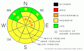
Here's where it gets tricky. First, familiarize yourself with the recent surface hoar (SH) avalanches. Most of the activity has been at and above treeline on slopes that face N, NE & E. With the recent warm temperatures, this is also the place where the best riding will be.

Abstinence is the best policy, by avoiding the above mentioned terrain, you're going to avoid a SH avalanche. If that doesn't sound like fun, then you're going to need to be very diligent about assessing slope stability before jumping onto them. Really, you're going to need to dig down and identify the SH and test it to see how it's behaving. You can also tweak small test slopes to see how they're behaving, but, I wouldn't bet the house on that test alone.

If testing is a bit too complex, then avoid slopes that are N, NE & E facing at and above treeline. Even if you're in the flats or meadows, be sure that there isn't more serious terrain above you.

Last, if you do see or trigger an avalanche, please, let us know. Photos are the best! You can report these events here, or see our contact info in the general announcements.


THREAT #2

WHERE PROBABILITY SIZE TREND
      Over the next 24 hours.

Unseasonably warm temperatures will once again be with us today. I expect some wet activity, mostly in the form of point release wet avalanches on low and mid elevation slopes that see the most sun, those that face W, SW, S, SE & E. Be especially heads up in gulley bottoms & other terrain traps where even a small amount of snow can pile up quickly. Once you start seeing roller balls (or pinwheels, danishes, whatever you want to call 'em) it's time to get off the slopes as there is some potential for larger wet activity in this second day of warm temperatures.


MOUNTAIN WEATHER

Today will once again be a scorcher by January standards with high's reaching into the 40's all the way to 10,000'. Winds will remain light as we head into the evening. Sunday is a different story. A storm system drops into our area Sunday afternoon, bringing 6" - 10" before dissipating Monday mid-day. Monday night brings frigid cold air into the range with overnight low's dropping below zero.


GENERAL ANNOUNCEMENTS

The information in this advisory expires 24 hours after the date and time posted, but will be updated by 7:00 AM Saturday Jan. 30th.

If you’re getting out and about and trigger an avalanche or see anything interesting please drop me an email at craig@utahavalanchecenter.org or call

The western Uinta advisory program is going full tilt and forecasts will be issued by 7:00 AM on Wednesday, Saturday, Sunday and all holidays.


This information does not apply to developed ski areas or highways where avalanche control is normally done.  This advisory is from the U.S.D.A. Forest Service, which is solely responsible for its content. This advisory describes general avalanche conditions and local variations always occur.


This advisory provided by the USDA Forest Service, in partnership with:

The Friends of the Utah Avalanche Center, Utah Division of State Parks and Recreation, Utah Division of Emergency Management, Salt Lake County, Salt Lake Unified Fire Authority and the friends of the La Sal Avalanche Center. See our Sponsors Page for a complete list.