SPECIAL ANNOUNCEMENT |
 |
Grant and I installed the Noblett’s Beacon Basin yesterday and it’s up and running. There’s four buried targets (numbered 1-4 on the control panel) and you can activate the system by simply flipping the switches to the "on" position. Many thanks to my hard working colleague Grant for all his great, high energy efforts helping to keep riders safe…. you rock man!
The Noblett’s Beacon Checker needs some attention and is not working properly. I will repair it later this week and keep y’all updated when it’s good to go. |
|
|
BOTTOM LINE
Danger by aspect and elevation on slopes approaching 35° or steeper.
(click HERE for tomorrow's danger rating)
|

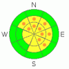
Danger Rose Tutorial
|
At and above treeline, most slopes have a Level 2 (MODERATE) avalanche danger and human triggered avalanches are possible, especially on steep wind drifted slopes that face Northwest through South.
Isolated and difficult to initiate, the possibility of triggering a large, scary slide that breaks into the buried surface hoar still exists, especially in terrain where the rain crust is starting to break down or wasn’t thick and bomber to begin with. While not widespread, pockets of Level 3 (CONSIDERABLE) avalanche danger will be found and human triggered avalanches are likely on slopes with these snowpack characteristics.
All other terrain has a Level 1 (LOW) avalanche danger. |
|
|
CURRENT CONDITIONS |

|
High pressure is building over the region as yesterdays quick hitting storm system slides east. Three inches of evenly distributed snow fell across the range, and temperatures are in the low 20’s. Westerly winds bumped up into the low 30’s for a few hours yesterday morning and then again late last night as they switched to the north. Currently, northerly winds are light, blowing 10-20 mph. Yesterday’s snow helped freshen things up a bit and very good riding and turning conditions will be found in all but the highest terrain where you’ll find some left over wind damage. |
|
|
RECENT ACTIVITY |

|
Ted Scroggin, our main man who keeps this program alive and who always rocks, took a look at a sled triggered slide which occurred on Saturday near Humpy Peak. The avalanche was 18”-24” deep, several hundred feet wide, running 400’ vertically. The weakness is this year’s problem child, a layer of preserved surface hoar. Click here for more details.
Also, we got a great observation of a slide that occurred Sunday near Yamaha Hill that has similar dimensions. Two riders were caught, one partially buried, but fortunately all came out on top and unscathed. Click here for more details. Thanks for the great info and thanks for helping to save other riders lives by sharing your experience and helping us to issue more precise advisories.
Click here for all Uinta snowpack and avalanche observations. |
|
|
THREAT #1 |

|
| WHERE |
PROBABILITY |
SIZE |
TREND |
|
|
|
|
| |
|
|
Over the next
24 hours.
|
|
|
There have been three unintentionally triggered avalanches that we know of in the past week and the layer of buried surface hoar is the culprit in all of them. Notoriously tricky to detect in the snowpack, surface hoar remains guilty until proven otherwise for long periods of time. Avalanches often pull out on the second, third or even fourth person to ride the slope. What’s making this situation particularly challenging is now a stout raincrust overlays this persistent weakness. While it feels bomber and good to go under our sled, skis or board, problem is it’s well connected and not broken up by terrain features like gullies, sub-ridges or trees. Because this crust is high in our snowpack it acts more like a cohesive slab. It supports our weight until we hit a thin spot in the crust, the slope collapses (whoomph) and we’ve triggered an avalanche and we’re off to the races. Wow… there’s a lot going on and that’s a lot to absorb. So that’s how the watch was built… but you wanna know what time it is, right? Well right now our best offense is a good defense. Occasionally you’ve got to stop and see how thick the crust is where you’re riding. If you feel that it’s getting thinner or breaking down in the drainage you’re in, do a little detective work and perhaps change slope aspect or elevation. If you don’t want to do your homework, then ride one at a time, chose terrain that has a runout where avalanche debris will fan out rather than stack up deeply, and above all- think about the consequences of triggering a slide. |
|
|
THREAT #2 |

|
| WHERE |
PROBABILITY |
SIZE |
TREND |
|
|
|
|
| |
|
|
Over the next
24 hours.
|
|
|
Mostly manageable in size and breaking at or below our feet, you’ll encounter fresh wind slabs along the leeward side of upper elevation ridges. Be aware, today’s shallow slabs could trigger a deeper slide as they descend the slope. So make sure you’re partners are watching you from a safe location and no one is below you in the impact zone. |
|
|
MOUNTAIN WEATHER |

|
High pressure builds into the region today through the end of the week, giving us partly cloudy to mostly sunny skies, light northerly winds, and warming temperatures. Highs today reach into the mid to upper 20’s with overnight lows near 15 degrees. Northerly winds average 10-20 mph with a gust or two in the low 30’s along the highest ridges. Not much going on ‘til maybe late in the weekend, but right now the computer models are all over the place on this one. |
|
|
GENERAL ANNOUNCEMENTS |
The information in this advisory expires 24 hours after the date and time posted, but will be updated by 7:00 AM Saturday Jan.29th.
If you’re getting out and about and trigger an avalanche or see anything interesting please drop me an email at craig@utahavalanchecenter.org or call 801-231-2170
The western Uinta advisory program is going full tilt and forecasts will be issued by 7:00 AM on Wednesday, Saturday, Sunday and all holidays. |
|
|
This information does not apply to developed ski areas or highways where avalanche control is normally done. This advisory is from the U.S.D.A. Forest Service, which is solely responsible for its content. This advisory describes general avalanche conditions and local variations always occur. |
|
This advisory provided by the USDA Forest Service, in partnership with:
The Friends of the Utah Avalanche Center, Utah Division of State Parks and Recreation, Utah Division of Emergency Management, Salt Lake County, Salt Lake Unified Fire Authority and the friends of the La Sal Avalanche Center. See our Sponsors Page for a complete list. |
